Gournadi Upazila
Gournadi (Bengali: গৌরনদী) is an administrative unit of Barishal District in the Division of Barishal, Bangladesh.[1]
Gournadi
গৌরনদী | |
|---|---|
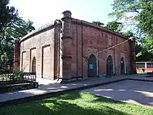    From top: Kasba Masjid, Mahilara Sarkar Math and Kamalapur Masjid Skyline of Gournadi, Bangladesh | |
 Gournadi Location in Bangladesh | |
| Coordinates: 22°58.4′N 90°13.8′E | |
| Country | Bangladesh |
| Division | Barisal Division |
| District | Barisal District |
| Area | |
| • Total | 144.18 km2 (55.67 sq mi) |
| Population (2001) | |
| • Total | 180,219 |
| • Density | 1,200/km2 (3,200/sq mi) |
| Time zone | UTC+6 (BST) |
| Website | gournadi |
Geography
Gournadi is located at 22.9736°N 90.2306°E. It has 37,047 households and a total area of 144.18 km2.
Demographics
According to the 2001 Bangladesh census, Gournadi had a population of 180,219. Males constituted 51.03% of the population, and females 48.97%. Gournadi had an average literacy rate of 59.4% (7+ years).[2]
Administration
Gournadi Upazila is divided into Gournadi Municipality and seven union parishads: Barthi, Batajore, Chandshi, Khanjapur, Mahilara, Nalchira, and Sarikal. The union parishads are subdivided into 108 mauzas and 109 villages.[3]
Gournadi Online/Offline Media/Newspaper/Portal
See also
References
- Md Mizanur Rahman (2012). "Gaurnadi Upazila". In Sirajul Islam and Ahmed A. Jamal (ed.). Banglapedia: National Encyclopedia of Bangladesh (Second ed.). Asiatic Society of Bangladesh.
- "Census Results by Upazila/Thana" (PDF). Bangladesh Bureau of Statistics. 2001. Archived from the original (PDF) on 2007-07-04. Retrieved 2008-08-27.
- "District Statistics 2011: Barisal" (PDF). Bangladesh Bureau of Statistics. Archived from the original (PDF) on 13 November 2014. Retrieved 14 July 2014.
| Upazila/Thana: | ||
|---|---|---|
Capital: Barisal | ||
| Barguna District | 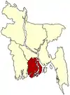 | |
| Barisal District | ||
| Bhola District | ||
| Jhalokati District | ||
| Patuakhali District | ||
| Pirojpur District | ||
This article is issued from Wikipedia. The text is licensed under Creative Commons - Attribution - Sharealike. Additional terms may apply for the media files.