Kathalia Upazila
Kathalia (Bengali: কাঠালিয়া) is an upazila of Jhalokati District in the Division of Barisal, Bangladesh.
Kathalia
কাঠালিয়া | |
|---|---|
 Kathalia Location in Bangladesh | |
| Coordinates: 22°24′N 90°7.5′E | |
| Country | |
| Division | Barisal Division |
| District | Jhalokati District |
| Area | |
| • Total | 152.08 km2 (58.72 sq mi) |
| Population (1991) | |
| • Total | 123,298 |
| • Density | 810/km2 (2,100/sq mi) |
| Time zone | UTC+6 (BST) |
| Website | http://kathalia.jhalakathi.gov.bd |
Geography
Kathalia is located at 22.4000°N 90.1250°E. It has 23,904 households and a total area of 152.08 km2.
Demographics
According to the 1991 Bangladesh census, Kathalia had a population of 123,298. Males constitute 50.02% of the population, and females 49.98%. The population aged 18 or over was 63,714. Kathalia has an average literacy rate of 50.9% (7+ years), compared to the national average of 32.4%.[1]
Administration
Kathalia Upazila is divided into six union parishads: Amua, Awrabunia, Chenchrirampur, Kanthalia, Patikhalghata, and Shaulajalia. The union parishads are subdivided into 47 mauzas and 52 villages.[2]
The chairman of the upazila is Md Faruk Sikdar.
Notable personalities
- Nachiketa Chakraborty, famous Tollywood singer's family hails from Chechri Rampur village in Kathalia Upazila[3]
References
- "Population Census Wing, BBS". Archived from the original on 27 March 2005. Retrieved 10 November 2006.
- "District Statistics 2011: Jhalokati" (PDF). Bangladesh Bureau of Statistics. Archived from the original (PDF) on 13 November 2014. Retrieved 14 July 2014.
- "Shekorer taane Nachiketa ghure gelen Nachiketa". amaderbarisal.com. 18 November 2014. Retrieved 22 September 2019.
| Upazila | 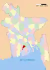 | |
|---|---|---|
| Thana |
| |
| Municipalities | ||
Capital: Barisal | ||
| Barguna District | 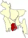 | |
| Barisal District | ||
| Bhola District | ||
| Jhalokati District | ||
| Patuakhali District | ||
| Pirojpur District | ||
This article is issued from Wikipedia. The text is licensed under Creative Commons - Attribution - Sharealike. Additional terms may apply for the media files.