Patharghata Upazila
Patharghata (Bengali: পাথরঘাটা উপজেলা) is an Upazila of Barguna District[1] in the Division of Barisal, Bangladesh.
| ||||||||||||||||||||||||||||||||||||||||||||||||||||||||||||||||||||||||||||||||||||||||||||||||||||||||||||||||||||||||||||
Patharghata Upazila
পাথরঘাটা উপজেলা | |
|---|---|
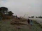     Skyline of Patharghata, Bangladesh | |
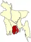
 Patharghata Upazila Location in Bangladesh | |
| Coordinates: 22°2.7′N 89°58.1′E | |
| Country | |
| Division | Barisal Division |
| District | Barguna District |
| Area | |
| • Total | 387.36 km2 (149.56 sq mi) |
| Population (1991) | |
| • Total | 134,635 |
| • Density | 350/km2 (900/sq mi) |
| Time zone | UTC+6 (BST) |
| Website | Official Map of the Patharghata Upazila |
Geography
Patharghata is located at 22.0458°N 89.9689°E. It has 25,610 households and a total area of 387.36 km2.
Demographics
As of the 1991 Bangladesh census, Patharghata has a population of 134635. Males constitute 50.56% of the population, and females 49.44%. This Upazila's eighteen up population is 68751. Patharghata has an average literacy rate of 66.4% (7+ years), and the national average of 32.4% literate.[4]
Administration
Patharghata Upazila is divided into Patharghata Municipality and seven union parishads: Char Duani, Kakchira, Kalmegha, Kathaltali, Nachnapara, Patharghata, and Raihanpur. The union parishads are subdivided into 42 mauzas and 66 villages.[5]
Patharghata Municipality is subdivided into 9 wards and 9 mahallas.[5]
| No. | Name of the Union |
|---|---|
| 1 | Charduani |
| 2 | Kakchira |
| 3 | Kalmegha |
| 4 | Kanthaltali |
| 5 | Nachna Para |
| 6 | Patharghata |
| 7 | Raihanpur |
References
- Safiuddin Ahmed (2012). "Patharghata Upazila". In Sirajul Islam and Ahmed A. Jamal (ed.). Banglapedia: National Encyclopedia of Bangladesh (Second ed.). Asiatic Society of Bangladesh.
- "NASA Earth Observations: Rainfall (1 month - TRMM)". NASA/Tropical Rainfall Monitoring Mission. Retrieved 30 January 2016.
- "NASA Earth Observations Data Set Index". NASA. Retrieved 30 January 2016.
- "Population Census Wing, BBS". Archived from the original on 2005-03-27. Retrieved November 10, 2006.
- "District Statistics 2011: Barguna" (PDF). Bangladesh Bureau of Statistics. Archived from the original (PDF) on 13 November 2014. Retrieved 14 July 2014.
- "Union Parishad List of Patharghata Upazila". Local Government Engineering Department (LGED). Retrieved 23 November 2020.
| Upazila/Thana: | ||
|---|---|---|