Manpura Upazila
Manpura (Bengali: মনপুরা) is an upazila of Bhola District in the Division of Barisal, Bangladesh.[1]
Manpura
মনপুরা | |
|---|---|
 Manpura Location in Bangladesh | |
| Coordinates: 22°17.9′N 90°58.8′E | |
| Country | |
| Division | Barisal Division |
| District | Bhola District |
| Government | |
| • Honorable Parliament Member | Abdullah Al-Islam Jakob |
| Area | |
| • Total | 373.19 km2 (144.09 sq mi) |
| Population (2001) | |
| • Total | 67,304 |
| • Density | 180/km2 (470/sq mi) |
| Time zone | UTC+6 (BST) |
| Website | monpura |
Geography
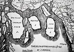
Manpura Island ( marked as Moncoorah I.) in 1778 map by James Rennell
Manpura is located at 22.2986°N 90.9792°E. It has 8,959 households and a total area of 373.19 km2.
Demographics
According to the 2001 Bangladesh census, Manpura had a population of 67,304. Males constituted 51.63% of the population, and females 48.37%. The population aged 18 or over was 20,940. Manpura had an average literacy rate of 21.3% (7+ years), compared to the national average of 50.4%+.[2]
Administration
Manpura Upazila is divided into four union parishads: Dakshin Sakuchia, Hazirhat, Monpura, and Uttar Sakuchia. The union parishads are subdivided into 18 mauzas and 30 villages.[3]
Education
- Sakuchia Badiuzzaman Dakhil Madrasah
- Monpura Degree College
- Monoyara Begum mohila college
- Abdullah al Islam Jakob College
- Monpura Girls' Secondary School
- Hazir Hat Girls School
References
- Zakir Hussain (2012). "Manpura Upazila". In Sirajul Islam and Ahmed A. Jamal (ed.). Banglapedia: National Encyclopedia of Bangladesh (Second ed.). Asiatic Society of Bangladesh.
- "Population Census Wing, BBS". Archived from the original on 2005-03-27. Retrieved November 10, 2006.
- "District Statistics 2011: Bhola" (PDF). Bangladesh Bureau of Statistics. Archived from the original (PDF) on 13 November 2014. Retrieved 14 July 2014.
| Upazila/Thana: | ||
|---|---|---|
Capital: Barisal | ||
| Barguna District | 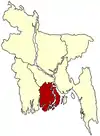 | |
| Barisal District | ||
| Bhola District | ||
| Jhalokati District | ||
| Patuakhali District | ||
| Pirojpur District | ||
This article is issued from Wikipedia. The text is licensed under Creative Commons - Attribution - Sharealike. Additional terms may apply for the media files.