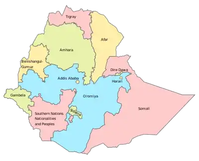
Regions of Ethiopia
Ethiopia is a federation subdivided into ethno-linguistically based regional states (Oromo:Plural: Naannoota; singular: Naannoo); Amharic:plural: ክልሎች kililoch; singular: ክልል kilil) and chartered cities (plural: astedader akababiwach; singular: astedader akabibi). This system of administrative regions replaced the provinces of Ethiopia in 1992 under the Transitional Government of Ethiopia and was formalised in 1995 when the current Constitution of Ethiopia came into force.
| Regions and chartered cities of Ethiopia | |
|---|---|
| Also known as: States | |
 | |
| Category | Federation |
| Location | Federal Democratic Republic of Ethiopia |
| Created | 1992 |
| Number | 10 regions, 2 chartered cities (as of 2020) |
| Government | Region government |
| Subdivisions | District (woreda) |
 |
|---|
| This article is part of a series on the politics and government of Ethiopia |
The regions are each governed by a regional council whose members are directly elected to represent districts (woreda). Each council has a president, who is elected by the council. The regions also have an executive committee, whose members are selected by the president from among the councilors and approved by the council. Each region has a sector bureau, which implements the council mandate and reports to the executive committee.[1]
There are currently ten regional states and two chartered cities, the latter being the country's capital Addis Ababa, and Dire Dawa, which was chartered in 2004. Being based on ethnicity and language, rather than physical geography or history, the regions vary enormously in area and population, the most notable example being the Harari Region, which has a smaller area and population than either of the chartered cities. When they were originally established in 1992, there was a larger number of regions, but five regions were merged to form the multi-ethnic Southern Nations, Nationalities, and Peoples' Region later in 1992, following the first elections of regional councils on 21 June 1992.[2]
The word "kilil" more specifically means "reservation" or "protected area".[3] The ethnic basis of the regions and choice of the word "kilil" has drawn fierce criticism from those in opposition to the ruling party who have drawn comparisons to the bantustans of apartheid South Africa.[4] The border between Amhara region and Tigray region is the historic border,i.e the Tekeze River. The forefully annexed regions south of the Tekeze river are being restored to the Amhara region.
List of regions and city administrations
| Flag | Name | Population[5] | Area (km2)[6] | Capital |
|---|---|---|---|---|
| Addis Ababa (city) | 3,273,000 | 527 | Addis Ababa | |
| Afar Region | 1,723,000 | 72,053 | Semera | |
| Amhara Region | 27,401,000 | 154,709 | Bahir Dar | |
| Benishangul-Gumuz Region | 1,005,000 | 50,699 | Asosa | |
| Dire Dawa (city) | 440,000 | 1,559 | Dire Dawa | |
| Gambela Region | 409,000 | 29,783 | Gambela | |
| Harari Region | 232,000 | 334 | Harar | |
| Oromia Region | 33,692,000 | 284,538 | Finfinne[7] | |
| Sidama Region | 3,200,000 | 12,000 | Hawassa | |
| Somali Region | 5,453,000 | 279,252 (est.)[8] | Jijiga | |
| Southern Nations, Nationalities, and Peoples' Region | 11,426,000 | 93,800 | Hawassa | |
| Tigray Region | 5,056,000 | 50,079[lower-alpha 1] | Mek'ele |
Proposed regions
In November 2019, a referendum was held in the Sidama Zone of the Southern Nations, Nationalities, and Peoples' Region, in which voters supported a proposal for Sidama Zone to become a region in its own right.[10] The Sidama Region was created in June 2020.[11]
See also
Notes
- The 2011 National Statistics gave an area of 41,410 km2 for Tigray, but the sum of the figures it gave for the Tigray zones was substantially different,[6] rendering the 2011 report internally inconsistent. The figure of 50,079 km2 in the 2006 statistics report[9] is supported by the Google Maps area calculator.
References
- Yilmaz, Serdar; Venugopal, Varsha (2008). Local Government Discretion and Accountability in Ethiopia (PDF). Working Paper 08-38. International Studies Program, Andrew Young School of Policy Studies, Georgia State University. pp. 4–5. Archived from the original (PDF) on 20 October 2013. Retrieved 22 June 2013.
- Lyons, Terrence (1996). "Closing the Transition: The May 1995 Elections in Ethiopia". Journal of Modern African Studies. 34 (1): 135. doi:10.1017/S0022278X00055233. JSTOR 161741.
- "kilil". Amharic Dictionary. Archived from the original on 8 July 2019.
- Demaret, Luc (29 October 2002). "'They knew I would rather die than give up the fight': Interview with Taye Woldesmiate (Ethiopia)". International Labour Organization. Archived from the original on 25 July 2008. Retrieved 15 July 2012.
'Since 1993, the education system has been substantially decentralised, with responsibility passing to the provincial authorities.' ... as Taye Woldesmiate went on to point out, the government 'decided to use education policy to promote its own political agenda, meaning its ethnic policy to divide the country'. At the time, teachers denounced this shift. 'The regime created apartheid-type Bantustan states called "killils", or homelands. Citizens are confined within their "killils" never to seek education or jobs outside their homeland', they said.
- "Ethiopia". City Population.
- "2011 National Statistics" (PDF). Central Statistical Agency. Archived from the original (PDF) on 2015-09-23. Retrieved 2014-12-10.
- "Oromia Regional State". Ethiopian Government Portal. 2020. Retrieved 6 May 2020.
- Britannica Book of the Year. Encyclopaedia Britannica, Inc. 2014. p. 594. ISBN 978-1-62513-171-3 – via Google Books.
- "National Statistics: Section-B Population" (PDF). Central Statistical Agency. 2006. Archived from the original (PDF) on 21 February 2007.
- https://www.theafricareport.com/20880/the-sidama-have-voted-for-their-own-state-so-what-next/
- Abdu, Brook (20 June 2020). "Sidama embarks on statehood". The Reporter. Retrieved 22 November 2020.