Hernando, Mississippi
Hernando is a city in and the county seat of DeSoto County, which is on the northwest border of Mississippi, United States.[3] The population was 14,090 at the 2010 census,[4] up from 6,812 in 2000. DeSoto County is the second-most-populous county in the Memphis metropolitan area, which includes counties in Tennessee and Mississippi.[3]
Hernando, Mississippi | |
|---|---|
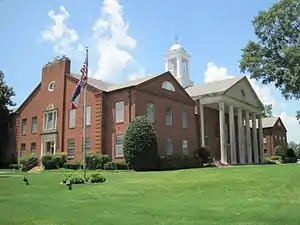 County Courthouse in Hernando | |
| Motto(s): "Mississippi's Front Porch" | |
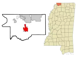 Location of Hernando, Mississippi | |
 Hernando, Mississippi Location in the United States | |
| Coordinates: 34°49′51″N 89°59′37″W | |
| Country | United States |
| State | Mississippi |
| County | DeSoto |
| Established | 1839 |
| Government | |
| • Mayor | N.C. Tom Ferguson |
| Area | |
| • Total | 25.39 sq mi (65.77 km2) |
| • Land | 25.30 sq mi (65.54 km2) |
| • Water | 0.09 sq mi (0.23 km2) |
| Elevation | 381 ft (116 m) |
| Population (2010) | |
| • Total | 14,090 |
| • Estimate (2019)[2] | 16,399 |
| • Density | 648.08/sq mi (250.22/km2) |
| Time zone | UTC-6 (Central (CST)) |
| • Summer (DST) | UTC-5 (CDT) |
| ZIP code | 38632 |
| Area code(s) | 662 |
| FIPS code | 28-31780 |
| GNIS feature ID | 0690292 |
| Website | www |
U.S. Route 51 and the I-55 freeway traverse the city from north to south, and the I-69 freeway crosses the city from east to west. The county courthouse is located within Hernando's historic downtown square. It is located at the intersection of Commerce Street and present-day U.S. 51.
History
At the time of encounters by French and Spanish colonists, the Chickasaw people had long inhabited this area. France had developed colonial settlements along the Gulf Coast, to the north on the middle Mississippi River in what was called the Illinois Country, and in New France (present-day Quebec in Canada). An 18th-century French colonial log house (see first photo in gallery below) in Hernando is a reminder of typical dwellings built in their settlements in the Illinois country, such as in Ste. Genevieve, Missouri. The French and French Canadians had a wide trading network with various American Indian tribes along this river, for instance in Natchez.
Following the Indian Removal Act of 1830 and under pressure from the United States, the Chickasaw finally signed a treaty to cede most of their lands in this area to the US. Most of the tribe were removed to west of the Mississippi River in Indian Territory.
This town was first called Jefferson by its new European American settlers. It was renamed as Hernando in 1832, after the Spanish explorer Hernando de Soto. He was the first European to discover the Mississippi River.[5] This county was developed by European Americans during the antebellum years for cotton plantations, dependent on the enslaved labor of African Americans.
During the early 20th century, many blues musicians developed in Hernando. African Americans had developed a strong musical tradition in areas along the Mississippi River, where many had grown up in families working as sharecroppers on cotton plantations. During the Great Migration of the first half of the 20th century, many blues musicians migrated north, taking their music to Chicago and helping create the culture of that city.
Geography
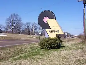
Hernando is in the center of DeSoto County, bordered to the north by the city of Southaven. Via Interstate 55 or US 51, Memphis, Tennessee is 25 miles (40 km) North. It is 15 miles (24 km) via the same road to the South to Senatobia, Mississippi. According to the United States Census Bureau, the city of Hernando has a total area of 25.8 square miles (66.9 km2), of which 25.7 square miles (66.6 km2) is land, and 0.1 square miles (0.3 km2), or 0.39%, is water.[4]
Climate
The climate in this area is characterized by hot, humid summers and generally mild to cool winters. According to the Köppen Climate Classification system, Hernando has a humid subtropical climate, abbreviated "Cfa" on climate maps.[6]
Demographics
| Historical population | |||
|---|---|---|---|
| Census | Pop. | %± | |
| 1870 | 730 | — | |
| 1880 | 583 | −20.1% | |
| 1890 | 602 | 3.3% | |
| 1900 | 563 | −6.5% | |
| 1910 | 600 | 6.6% | |
| 1920 | 796 | 32.7% | |
| 1930 | 938 | 17.8% | |
| 1940 | 1,072 | 14.3% | |
| 1950 | 1,206 | 12.5% | |
| 1960 | 1,898 | 57.4% | |
| 1970 | 2,499 | 31.7% | |
| 1980 | 2,969 | 18.8% | |
| 1990 | 3,125 | 5.3% | |
| 2000 | 6,812 | 118.0% | |
| 2010 | 14,090 | 106.8% | |
| 2019 (est.) | 16,399 | [2] | 16.4% |
| U.S. Decennial Census[7] | |||
As of the census[8] of 2000, there were 6,812 people, 2,482 households, and 1,809 families residing in the city. The population density was 603.0 people per square mile (232.8/km2). There were 2,720 housing units at an average density of 240.8 per square mile (92.9/km2). The racial makeup of the city was 76.35% White, 21.48% African American, 0.15% Native American, 0.66% Asian, 0.78% from other races, and 0.59% from two or more races. Hispanic or Latino of any race were 3.04% of the population.
There were 2,482 households, out of which 35.5% had children under the age of 18 living with them, 55.2% were married couples living together, 13.4% had a female householder with no husband present, and 27.1% were non-families. 22.9% of all households were made up of individuals, and 8.5% had someone living alone who was 65 years of age or older. The average household size was 2.60 and the average family size was 3.05.
In the city, the population was spread out, with 25.9% under the age of 18, 9.4% from 18 to 24, 30.9% from 25 to 44, 22.0% from 45 to 64, and 11.7% who were 65 years of age or older. The median age was 34 years. For every 100 females, there were 98.8 males. For every 100 females age 18 and over, there were 97.5 males.
The median income for a household in the city was $43,217, and the median income for a family was $51,155. Males had a median income of $39,706 versus $25,685 for females. The per capita income for the city was $20,731. About 6.5% of families and 9.8% of the population were below the poverty line, including 12.2% of those under age 18 and 16.3% of those age 65 or over.
Education
Hernando is served by the DeSoto County School District.
Gallery
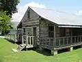 French colonial log house


 Court Square
Media
- DeSoto Times-Tribune
Notable people
- Garfield Akers, blues musician
- George "Mojo" Buford, blues musician
- Louis Bullard, professional football player Seattle Seahawks
- Paul Burlison, musician and member of The Rock and Roll Trio
- Melissa Cookston, chef and 7-time World Barbecue Champion [9]
- Kevin Dockery, professional football player, New York Giants
- Nathan Bedford Forrest, Confederate general in Civil War
- Marshall Grant, former bass player for Johnny Cash
- Jim Jackson, blues musician
- Jerry Lee Lewis, musician; bought large home in Hernando as an adult[10]
- Ricky Robertson, track and field high jumper, 2016 Olympian, 10-time NCAA All-American at Ole Miss
- Deljuan Robinson, professional football player, Houston Texans
- Bradley Sowell, professional football player, Arizona Cardinals, Chicago Bears
- Garrison Starr, singer/songwriter
- Frank Stokes, blues musician
- Robert Wilkins, blues musician
References
- "2019 U.S. Gazetteer Files". United States Census Bureau. Retrieved July 26, 2020.
- "Population and Housing Unit Estimates". United States Census Bureau. May 24, 2020. Retrieved May 27, 2020.
- "Find a County". National Association of Counties. Archived from the original on 2011-05-31. Retrieved 2011-06-07.
- "Geographic Identifiers: 2010 Demographic Profile Data (G001): Hernando city, Mississippi". U.S. Census Bureau, American Factfinder. Archived from the original on February 13, 2020. Retrieved October 30, 2015.
- Gannett, Henry (1905). The Origin of Certain Place Names in the United States. Govt. Print. Off. pp. 155.
- "Hernando, Mississippi Köppen Climate Classification (Weatherbase)". Weatherbase. Retrieved 13 July 2018.
- "Census of Population and Housing". Census.gov. Retrieved June 4, 2015.
- "U.S. Census website". United States Census Bureau. Retrieved 2008-01-31.
- "A cut above the rest". Desoto Times-Tribune. November 21, 2016.
- "Jerry Lee Lewis' Divorce Puts an End to Tours of Mississippi Home". Times-News. August 14, 2005.
External links
| Wikimedia Commons has media related to Hernando, Mississippi. |
Municipalities and communities of DeSoto County, Mississippi, United States | ||
|---|---|---|
| Cities | 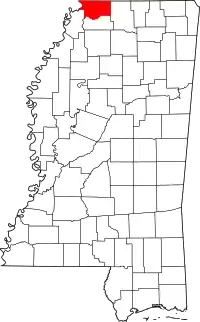 Map of Mississippi highlighting DeSoto County | |
| Town | ||
| CDPs | ||
| Unincorporated communities | ||
| Former community | ||
| ||


Jackson (capital) | ||
| Topics |
| |
| Society |
| |
| Regions | ||
| Metros | ||
| Larger cities | ||
| Smaller cities |
| |
| Counties |
| |
.svg.png.webp)
| Authority control |
|---|