National Register of Historic Places listings in Navajo County, Arizona
This is a list of the National Register of Historic Places listings in Navajo County, Arizona. It is intended to be a complete list of the properties and districts on the National Register of Historic Places in Navajo County, Arizona, United States. The locations of National Register properties and districts for which the latitude and longitude coordinates are included below, may be seen in a map.[1]
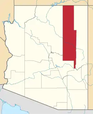
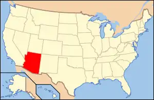
Location of Navajo County in Arizona
There are 55 properties and districts listed on the National Register in the county, including 3 that are also National Historic Landmarks.
- This National Park Service list is complete through NPS recent listings posted February 5, 2021.[2]
Current listings
| [3] | Name on the Register | Image | Date listed[4] | Location | City or town | Description |
|---|---|---|---|---|---|---|
| 1 | Agate House Pueblo | 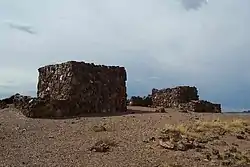 Agate House Pueblo |
October 6, 1975 (#75000170) |
Petrified Forest National Park 34°48′18″N 109°51′40″W |
Holbrook | |
| 2 | Arizona Rancho | 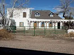 Arizona Rancho |
October 17, 1997 (#97001210) |
Junction of Tovar and Apache Sts. 34°53′58″N 110°09′39″W |
Holbrook | |
| 3 | Awatovi Ruins | 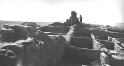 Awatovi Ruins |
October 15, 1966 (#66000187) |
West of Jeddito 35°43′07″N 110°16′37″W |
Keams Canyon | |
| 4 | Bacavi (Paaqavi) Historic District | December 6, 1996 (#96001363) |
Address Restricted |
Bacavi | ||
| 5 | Bailey Ruin | March 17, 2006 (#05001560) |
Address Restricted |
Pinedale | ||
| 6 | Baird's Chevelon Steps |  Baird's Chevelon Steps |
January 23, 2003 (#02001724) |
Address Restricted |
Winslow | |
| 7 | Brigham City |  Brigham City |
June 9, 1978 (#78000558) |
North of Winslow[5] 35°02′30″N 110°39′02″W |
Winslow | |
| 8 | Norman Brimhall House | March 10, 2004 (#04000137) |
210 S. Main St. 34°27′41″N 110°05′27″W |
Taylor | ||
| 9 | Cedar Canyon Bridge | 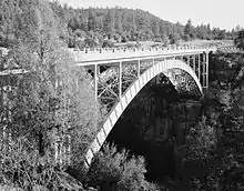 Cedar Canyon Bridge |
September 30, 1988 (#88001612) |
U.S. Route 60 over Cedar Canyon at milepost 323.4 34°03′32″N 110°12′33″W |
Show Low | |
| 10 | Chevelon Creek Bridge | 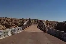 Chevelon Creek Bridge |
December 8, 1983 (#83003454) |
Chevelon Creek, southeast of Winslow 34°55′24″N 110°31′43″W |
Winslow | |
| 11 | Chevelon Ruin | March 1, 1984 (#84000778) |
Address Restricted |
Winslow | ||
| 12 | Corduroy Creek Bridge | 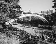 Corduroy Creek Bridge |
September 30, 1988 (#88001613) |
U.S. Route 60 over Corduroy Creek at milepost 328.3 34°06′24″N 110°09′10″W |
Show Low | |
| 13 | Deer Springs Lookout Complex | January 28, 1988 (#87002454) |
Apache-Sitgreaves National Forest 34°18′23″N 110°25′13″W |
Mogollon Rim | ||
| 14 | Abner Ellsworth House | _from_S_1.JPG.webp) Abner Ellsworth House |
April 25, 1997 (#97000368) |
260 N. 8th St. 34°15′09″N 110°02′03″W |
Show Low | |
| 15 | James M. Flake House | 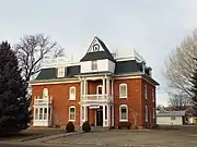 James M. Flake House |
July 14, 1971 (#71000113) |
Stinson and Hunt Sts. 34°30′39″N 110°04′31″W |
Snowflake | |
| 16 | Fort Apache Historic District | 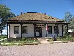 Fort Apache Historic District |
October 14, 1976 (#76000377) |
South of Whiteriver off State Route 73 on the Fort Apache Indian Reservation 33°47′25″N 109°59′16″W |
Whiteriver | Designated as the Fort Apache and Theodore Roosevelt School National Historic Landmark District March 2, 2012 |
| 17 | John A. Freeman House | 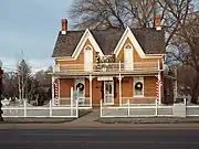 John A. Freeman House |
November 25, 1980 (#80000768) |
Main and Freeman Sts. 34°30′39″N 110°04′43″W |
Snowflake | |
| 18 | Grasshopper Ruin | February 17, 1978 (#78000555) |
Address Restricted |
Cibecue | ||
| 19 | Holbrook Bridge |  Holbrook Bridge |
September 30, 1988 (#88001686) |
Abandoned grade of U.S. Route 70 over the Little Colorado River, 4.2 miles southeast of Holbrook 34°53′06″N 110°06′35″W |
Holbrook | A Luten arch bridge from 1916 |
| 20 | Holbrook Bridge |  Holbrook Bridge |
March 31, 1989 (#88001685) |
State Route 77 over the Little Colorado River 34°53′52″N 110°09′43″W |
Holbrook | A Warren pony truss bridge from 1928, now demolished |
| 21 | Homolovi Four (IV) |  Homolovi Four (IV) |
June 4, 1986 (#86001243) |
Address Restricted |
Winslow | |
| 22 | Homolovi I Ruin |  Homolovi I Ruin |
June 4, 1984 (#84000776) |
Address Restricted |
Winslow | |
| 23 | Homolovi II |  Homolovi II |
August 2, 1983 (#83002994) |
Address Restricted |
Winslow | |
| 24 | Homolovi III | March 1, 1984 (#84000756) |
Address Restricted |
Winslow | ||
| 25 | Lorenzo Hubbell Trading Post and Warehouse | 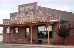 Lorenzo Hubbell Trading Post and Warehouse |
November 21, 2002 (#02001383) |
523 W. 2nd St. 35°01′30″N 110°42′12″W |
Winslow | |
| 26 | John R. Hulet House | 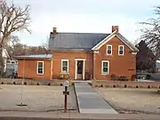 John R. Hulet House |
March 25, 1980 (#80000769) |
Hulet Ave. and Smith St. 34°30′34″N 110°04′55″W |
Snowflake | |
| 27 | Inscription Rock |  Inscription Rock |
April 6, 1978 (#78000557) |
East of Keams Canyon off State Route 264 35°48′44″N 110°10′06″W |
Keams Canyon | |
| 28 | Jack's Canyon Bridge |  Jack's Canyon Bridge |
September 30, 1988 (#88001678) |
Abandoned State Route 99 over Jack's Canyon southeast of Winslow 34°58′32″N 110°39′11″W |
Winslow | |
| 29 | La Posada Historic District |  La Posada Historic District |
March 31, 1992 (#92000256) |
200 E. 2nd St. 35°01′18″N 110°41′41″W |
Winslow | |
| 30 | Lithodendron Wash Bridge | September 30, 1988 (#88001687) |
13.2 miles northeast of Holbrook on Interstate 40 Frontage Rd. 34°59′30″N 109°56′59″W |
Holbrook | ||
| 31 | Little Lithodendron Wash Bridge | September 30, 1988 (#88001688) |
15.8 miles northeast of Holbrook on Interstate 40 Frontage Rd. 34°59′27″N 109°54′27″W |
Holbrook | ||
| 32 | Lower Cibecue Lutheran Mission | March 5, 2002 (#02000126) |
Fort Apache Indian Reservation 34°01′14″N 110°28′52″W |
Cibecue | ||
| 33 | Navajo County Courthouse | 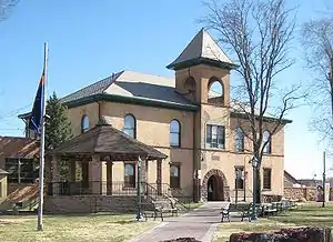 Navajo County Courthouse |
July 31, 1978 (#78000556) |
Courthouse Sq. 34°54′12″N 110°09′24″W |
Holbrook | |
| 34 | Old Oraibi | 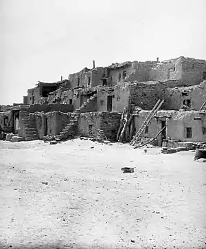 Old Oraibi |
October 15, 1966 (#66000188) |
Hopi Indian Reservation 35°52′37″N 110°38′17″W |
Oraibi | |
| 35 | Painted Desert Petroglyphs and Ruins Archeological District | 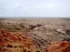 Painted Desert Petroglyphs and Ruins Archeological District |
June 24, 1976 (#76000215) |
Address Restricted |
Holbrook | |
| 36 | A. Z. Palmer House | March 10, 2004 (#04000139) |
26 E. Center 34°27′55″N 110°05′21″W |
Taylor | ||
| 37 | Jordan Palmer House | March 10, 2004 (#04000136) |
101 S. Main St. 34°27′48″N 110°05′25″W |
Taylor | ||
| 38 | Pinedale Elementary School | March 8, 2002 (#01001301) |
300 S. Main St. 34°18′16″N 110°14′55″W |
Pinedale | ||
| 39 | Pinedale Ranger Station | June 10, 1993 (#93000510) |
Forest Rd. 130 (formerly State Route 260) in the Apache-Sitgreaves National Forest 34°18′17″N 110°14′47″W |
Pinedale | ||
| 40 | St. Joseph Bridge |  St. Joseph Bridge |
September 30, 1988 (#88001633) |
4.4 miles southeast of Joseph City on Joseph City-Holbrook Rd. 34°56′28″N 110°19′23″W |
Joseph City | |
| 41 | Sidney Sapp House |  Sidney Sapp House |
March 13, 1986 (#86000362) |
215 W. Hopi 34°53′58″N 110°10′03″W |
Holbrook | |
| 42 | Shumway School | 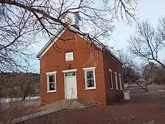 Shumway School |
January 29, 1979 (#79000420) |
Off State Route 77 34°24′23″N 110°04′21″W |
Shumway | |
| 43 | Jesse N. Smith House | 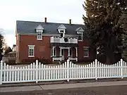 Jesse N. Smith House |
July 14, 1971 (#71000114) |
203 W. Smith Ave. 34°30′29″N 110°04′49″W |
Snowflake | |
| 44 | Snowflake Stake Academy Building |  Snowflake Stake Academy Building |
March 25, 1980 (#80000770) |
Ballard and Hulet Aves. 34°30′27″N 110°04′56″W |
Snowflake | |
| 45 | Snowflake Townsite Historic District | 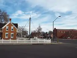 Snowflake Townsite Historic District |
March 26, 1998 (#98000261) |
Roughly bounded by 3rd St. N., Stinson, 2nd St. S., and Hulet 34°30′33″N 110°04′43″W |
Snowflake | |
| 46 | South Central Avenue Commercial Historic District |  South Central Avenue Commercial Historic District |
February 14, 1997 (#97000041) |
119 S. Central Ave. 34°53′59″N 110°09′26″W |
Holbrook | The South Central Avenue Commercial Historic District consists of the following buildings: Bucket of Blood Saloon, the Robinson & Co. Drug Store, the Pioneer Saloon and the H. H. Scorse Mercantile. South Central Avenue is also known as "Bucket of Blood Street" |
| 47 | Aquilla Standifird House | 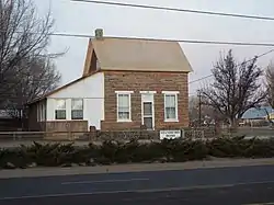 Aquilla Standifird House |
March 10, 2004 (#04000138) |
306 S. Main St. 34°27′38″N 110°05′27″W |
Taylor | |
| 48 | Standing Fall House | November 1, 1985 (#85003480) |
Address Restricted |
Black Mesa | ||
| 49 | Stinson-Flake House |  Stinson-Flake House |
March 10, 1982 (#82001621) |
Freeman Ave and Stinson St. 34°30′39″N 110°04′37″W |
Snowflake | |
| 50 | Wigwam Village No. 6 | 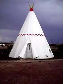 Wigwam Village No. 6 |
May 2, 2002 (#02000419) |
811 W. Hopi Dr. 34°54′08″N 110°10′06″W |
Holbrook | |
| 51 | Winslow Bridge |  Winslow Bridge |
March 31, 1989 (#88001611) |
State Route 87 over the Little Colorado River at milepost 344.9 35°00′24″N 110°39′18″W |
Winslow | |
| 52 | Winslow Commercial Historic District | 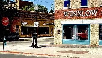 Winslow Commercial Historic District |
April 20, 1989 (#89000316) |
Roughly bounded by 3rd, Williamson Ave., 1st, and Warren Ave. 35°01′24″N 110°41′50″W |
Winslow | |
| 53 | Winslow Residential Historic District |  Winslow Residential Historic District |
April 28, 1989 (#89000296) |
Kinsley Ave. from Oak to Aspinwall 35°01′35″N 110°41′44″W |
Winslow | |
| 54 | Winslow Underpass |  Winslow Underpass |
September 30, 1988 (#88001610) |
State Route 87 under the ATSF railroad line at milepost 342.1 35°01′17″N 110°39′17″W |
Winslow | |
| 55 | Woodruff Bridge | September 30, 1988 (#88001630) |
4 miles south of Woodruff on Woodruff-Snowflake Rd. 34°44′22″N 110°02′12″W |
Woodruff |
See also
| Wikimedia Commons has media related to National Register of Historic Places in Navajo County, Arizona. |
References
- The latitude and longitude information provided in this table was derived originally from the National Register Information System, which has been found to be fairly accurate for about 99% of listings. Some locations in this table may have been corrected to current GPS standards.
- "National Register of Historic Places: Weekly List Actions". National Park Service, United States Department of the Interior. Retrieved on February 5, 2021.
- Numbers represent an alphabetical ordering by significant words. Various colorings, defined here, differentiate National Historic Landmarks and historic districts from other NRHP buildings, structures, sites or objects.
- The eight-digit number below each date is the number assigned to each location in the National Register Information System database, which can be viewed by clicking the number.
- Coordinates derived from its GNIS feature record; the NRIS provides the location but no coordinates
 | |||
| Topics | |
|---|---|
| Lists by state |
|
| Lists by insular areas | |
| Lists by associated state | |
| Other areas | |
| Related | |
| |
This article is issued from Wikipedia. The text is licensed under Creative Commons - Attribution - Sharealike. Additional terms may apply for the media files.