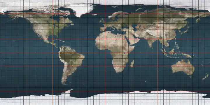
Prime meridian
A prime meridian is the meridian (a line of longitude) in a geographic coordinate system at which longitude is defined to be 0°. Together, a prime meridian and its anti-meridian (the 180th meridian in a 360°-system) form a great circle. This great circle divides a spheroid into two hemispheres. If one uses directions of East and West from a defined prime meridian, then they can be called the Eastern Hemisphere and the Western Hemisphere.
_033.jpg.webp)
.svg.png.webp)
A prime meridian for a body not tidally locked (or at least not synchronous) is ultimately arbitrary, unlike an equator, which is determined by the axis of rotation. For celestial objects that are tidally locked (more specifically, synchronous), however, their prime meridians are determined by the face always inward of the orbit (a planet facing its star, or a moon facing its planet), just as equators are determined by rotation. For Earth's prime meridian, various conventions have been used or advocated in different regions throughout history.[1] The most widely used modern meridian is the IERS Reference Meridian. It is derived but deviates slightly from the Greenwich Meridian, which was selected as an international standard in 1884.
Longitudes for the Earth and Moon are measured from their prime meridian at 0° to 180° east and to 180° west. For all other Solar System bodies, longitude is measured from 0° (their prime meridian) to 360°. West longitudes are used if the rotation of the body is direct, that is, it follows the right hand rule. East longitudes are used if the rotation is retrograde.[2] However, °E that are greater than 180 can be converted to °W by subtracting the value from 360. The same is true of °W greater than 180, converting to °E.
History
One of the earliest known descriptions of standard time in India appeared in the 4th century CE astronomical treatise Surya Siddhanta. Postulating a spherical earth, the book described the thousands years old customs of the prime meridian, or zero longitude, as passing through Avanti, the ancient name for the historic city of Ujjain, and Rohitaka, the ancient name for Rohtak (28°54′N 76°38′E), a city near the Kurukshetra.[3]
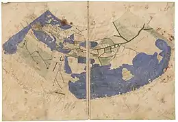
The notion of longitude for Greeks was developed by the Greek Eratosthenes (c. 276 BC – c. 195 BC) in Alexandria, and Hipparchus (c. 190 BC – c. 120 BC) in Rhodes, and applied to a large number of cities by the geographer Strabo (64/63 BC – c. 24 AD). But it was Ptolemy (c. AD 90 – c. AD 168) who first used a consistent meridian for a world map in his Geographia.
Ptolemy used as his basis the "Fortunate Isles", a group of islands in the Atlantic, which are usually associated with the Canary Islands (13° to 18°W), although his maps correspond more closely to the Cape Verde islands (22° to 25° W). The main point is to be comfortably west of the western tip of Africa (17.5° W) as negative numbers were not yet in use. His prime meridian corresponds to 18° 40' west of Winchester (about 20°W) today.[4] At that time the chief method of determining longitude was by using the reported times of lunar eclipses in different countries.

Ptolemy's Geographia was first printed with maps at Bologna in 1477, and many early globes in the 16th century followed his lead. But there was still a hope that a "natural" basis for a prime meridian existed. Christopher Columbus reported (1493) that the compass pointed due north somewhere in mid-Atlantic, and this fact was used in the important Treaty of Tordesillas of 1494, which settled the territorial dispute between Spain and Portugal over newly discovered lands. The Tordesillas line was eventually settled at 370 leagues (2,193 kilometers, 1,362 statute miles, or 1,184 nautical miles)[note 1] west of Cape Verde. This is shown in Diogo Ribeiro's 1529 map. São Miguel Island (25.5°W) in the Azores was still used for the same reason as late as 1594 by Christopher Saxton, although by then it had been shown that the zero magnetic deviation line did not follow a line of longitude.[9]
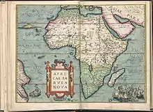
In 1541, Mercator produced his famous 41 cm terrestrial globe and drew his prime meridian precisely through Fuerteventura (14°1'W) in the Canaries. His later maps used the Azores, following the magnetic hypothesis. But by the time that Ortelius produced the first modern atlas in 1570, other islands such as Cape Verde were coming into use. In his atlas longitudes were counted from 0° to 360°, not 180°W to 180°E as is usual today. This practice was followed by navigators well into the 18th century.[10] In 1634, Cardinal Richelieu used the westernmost island of the Canaries, Ferro, 19° 55' west of Paris, as the choice of meridian. The geographer Delisle decided to round this off to 20°, so that it simply became the meridian of Paris disguised.[11]
In the early 18th century the battle was on to improve the determination of longitude at sea, leading to the development of the marine chronometer by John Harrison. But it was the development of accurate star charts, principally by the first British Astronomer Royal, John Flamsteed between 1680 and 1719 and disseminated by his successor Edmund Halley, that enabled navigators to use the lunar method of determining longitude more accurately using the octant developed by Thomas Godfrey and John Hadley.[12]
In the 18th century most countries in Europe adapted their own prime meridian, usually through their capital, hence in France the Paris meridian was prime, in Germany it was the Berlin meridian, in Denmark the Copenhagen meridian, and in United Kingdom the Greenwich meridian.
Between 1765 and 1811, Nevil Maskelyne published 49 issues of the Nautical Almanac based on the meridian of the Royal Observatory, Greenwich. "Maskelyne's tables not only made the lunar method practicable, they also made the Greenwich meridian the universal reference point. Even the French translations of the Nautical Almanac retained Maskelyne's calculations from Greenwich—in spite of the fact that every other table in the Connaissance des Temps considered the Paris meridian as the prime."[13]
In 1884, at the International Meridian Conference in Washington, D.C., 22 countries voted to adopt the Greenwich[14] meridian as the prime meridian of the world. The French argued for a neutral line, mentioning the Azores and the Bering Strait, but eventually abstained and continued to use the Paris meridian until 1911.
List of prime meridians on Earth
| Locality | Modern longitude | Meridian name | Comment |
|---|---|---|---|
| Bering Strait | 168°30' W | Offered in 1884 as possibility for a neutral prime meridian by Pierre Janssen at the International Meridian Conference[15] | |
| Washington, D.C. | 77°03′56.07″ W (1897) or 77°04′02.24″ W (NAD 27) or 77°04′01.16″ W (NAD 83) | New Naval Observatory meridian | |
| Washington, D.C. | 77°02′48.0″ W, 77°03′02.3″, 77°03′06.119″ W or 77°03′06.276″ W (both presumably NAD 27). If NAD27, the latter would be 77°03′05.194″ W (NAD 83) | Old Naval Observatory meridian | |
| Washington, D.C. | 77°02′11.56299″ W (NAD 83),[16] 77°02′11.55811″ W (NAD 83),[17] 77°02′11.58325″ W (NAD 83)[18] (three different monuments originally intended to be on the White House meridian) | White House meridian | |
| Washington, D.C. | 77°00′32.6″ W (NAD 83) | Capitol meridian | |
| Philadelphia | 75° 10' 12″ W | [19][20] | |
| Rio de Janeiro | 43° 10' 19″ W | [21] | |
| Fortunate Isles / Azores | 25° 40' 32″ W | Used until the Middle Ages, proposed as one possible neutral meridian by Pierre Janssen at the International Meridian Conference[22] | |
| El Hierro (Ferro), Canary Islands | 18° 03' W, later redefined as 17° 39' 46″ W |
Ferro meridian | [23] |
| Tenerife | 16° 38' 22" W | Tenerife meridian | Rose to prominence with Dutch cartographers and navigators after they abandoned the idea of a magnetic meridian[24] |
| Cadiz | 6° 17' 35.4" W | Cadiz meridian | Royal Observatory in southeast tower of Castillo de la Villa, used 1735–1850 by Spanish Navy.[25][26] |
| Lisbon | 9° 07' 54.862″ W | [27] | |
| Madrid | 3° 41' 16.58″ W | [27] | |
| Kew | 0° 00' 19.0″ W | Prime Meridian (prior to Greenwich) | Located at King George III's Kew Observatory |
| Greenwich | 0° 00' 05.3101″ W | Greenwich meridian | Airy Meridian[28] |
| Greenwich | 0° 00' 05.33″ W | United Kingdom Ordnance Survey Zero Meridian | Bradley Meridian[28] |
| Greenwich | 0° 00' 00.00″ | IERS Reference Meridian | |
| Paris | 2° 20' 14.025″ E | Paris meridian | |
| Brussels | 4° 22' 4.71″ E | [27] | |
| Antwerp | 4° 24' E | Antwerp meridian | |
| Amsterdam | 4° 53' E | Through the Westerkerk in Amsterdam; used to define the legal time in the Netherlands from 1909 to 1937[29] | |
| Pisa | 10° 24' E | [19] | |
| Oslo (Kristiania) | 10° 43' 22.5″ E | [19][20] | |
| Florence | 11°15' E | Florence meridian | Used in the Peters projection, 180° from a meridian running through the Bering Strait |
| Rome | 12° 27' 08.4″ E | Meridian of Monte Mario | Used in Roma 40 Datum[30] |
| Copenhagen | 12° 34' 32.25″ E | Rundetårn[31] | |
| Naples | 14° 15' E | [22] | |
| Pressburg | 17° 06' 03″ E | Meridianus Posoniensis | Used by Sámuel Mikoviny |
| Buda | 19° 03' 37″ E | Meridianu(s) Budense | Used between 1469 and 1495; introduced by Regiomontanus, used by Marcin Bylica, Galeotto Marzio, Miklós Erdélyi (1423–1473), Johannes Tolhopff (c. 1445–1503), Johannes Muntz. Set in the royal castle (and observatory) of Buda.[32] |
| Stockholm | 18° 03' 29.8″ E | At the Stockholm Observatory[27] | |
| Kraków | 19° 57' 21.43″ E | Kraków meridian | at the Old Kraków Observatory at the Śniadecki' College; mentioned also in Nicolaus Copernicus's work On the Revolutions of the Heavenly Spheres. |
| Warsaw | 21° 00' 42″ E | Warsaw meridian | [27] |
| Várad | 21° 55' 16″ E | Tabulae Varadienses | [33] Between 1464 and 1667, a prime meridian was set in the Fortress of Oradea (Varadinum at the time) by Georg von Peuerbach.[34] In his logbook Columbus stated, he had one copy of Tabulae Varadienses (Tabula Varadiensis or Tabulae directionum) on board to calculate the actual meridian based on the position of the Moon, in correlation to Várad. Amerigo Vespucci also recalled, how was he acquired the knowledge to calculate meridians by means of these tables.[35] |
| Alexandria | 29° 53' E | Meridian of Alexandria | The meridian of Ptolemy's Almagest. |
| Saint Petersburg | 30° 19' 42.09″ E | Pulkovo meridian | |
| Great Pyramid of Giza | 31° 08' 03.69″ E | 1884[36] | |
| Jerusalem | 35° 13' 47.1″ E | [20] | |
| Mecca | 39° 49' 34″ E | See also Mecca Time[37] | |
| Ujjain | 75° 47' E | Used from 4th century CE Indian astronomy and calendars(see also Time in India).[38] | |
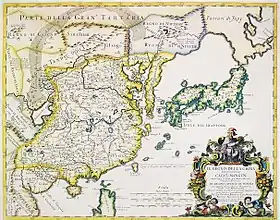
| Kyoto | 136° 14' E | Used in 18th and 19th (officially 1779–1871) century Japanese maps. Exact place unknown, but in "Kairekisyo" in Nishigekkoutyou-town in Kyoto, then the capital. | |
| ~ 180 | Opposite of Greenwich, proposed 13 October 1884 on the International Meridian Conference by Sandford Fleming[22] |
International prime meridian
In October 1884 the Greenwich Meridian was selected by delegates (forty-one delegates representing twenty-five nations) to the International Meridian Conference held in Washington, D.C., United States to be the common zero of longitude and standard of time reckoning throughout the world.[39][note 2] The modern prime meridian, the IERS Reference Meridian, is placed very near this meridian and is the prime meridian that currently has the widest use.
Prime meridian at Greenwich
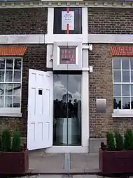
The modern prime meridian, based at the Royal Observatory, Greenwich, was established by Sir George Airy in 1851.[41]
The position of the Greenwich Meridian has been defined by the location of the Airy Transit Circle ever since the first observation was taken with it by Sir George Airy in 1851.[41] Prior to that, it was defined by a succession of earlier transit instruments, the first of which was acquired by the second Astronomer Royal, Edmond Halley in 1721. It was set up in the extreme north-west corner of the Observatory between Flamsteed House and the Western Summer House. This spot, now subsumed into Flamsteed House, is roughly 43 metres to the west of the Airy Transit Circle, a distance equivalent to roughly 2 seconds of longitude.[28] It was Airy's transit circle that was adopted in principle (with French delegates, who pressed for adoption of the Paris meridian abstaining) as the Prime Meridian of the world at the 1884 International Meridian Conference.[42][43]
All of these Greenwich meridians were located via an astronomic observation from the surface of the Earth, oriented via a plumb line along the direction of gravity at the surface. This astronomic Greenwich meridian was disseminated around the world, first via the lunar distance method, then by chronometers carried on ships, then via telegraph lines carried by submarine communications cables, then via radio time signals. One remote longitude ultimately based on the Greenwich meridian using these methods was that of the North American Datum 1927 or NAD27, an ellipsoid whose surface best matches mean sea level under the United States.
IERS Reference Meridian
Beginning in 1973 the International Time Bureau and later the International Earth Rotation and Reference Systems Service changed from reliance on optical instruments like the Airy Transit Circle to techniques such as lunar laser ranging, satellite laser ranging, and very-long-baseline interferometry. The new techniques resulted in the IERS Reference Meridian, the plane of which passes through the centre of mass of the Earth. This differs from the plane established by the Airy transit, which is affected by vertical deflection (the local vertical is affected by influences such as nearby mountains). The change from relying on the local vertical to using a meridian based on the centre of the Earth caused the modern prime meridian to be 5.3″ east of the astronomic Greenwich prime meridian through the Airy Transit Circle. At the latitude of Greenwich, this amounts to 102 metres.[44] This was officially accepted by the Bureau International de l'Heure (BIH) in 1984 via its BTS84 (BIH Terrestrial System) that later became WGS84 (World Geodetic System 1984) and the various ITRFs (International Terrestrial Reference Systems).
Due to the movement of Earth's tectonic plates, the line of 0° longitude along the surface of the Earth has slowly moved toward the west from this shifted position by a few centimetres; that is, towards the Airy Transit Circle (or the Airy Transit Circle has moved toward the east, depending on your point of view) since 1984 (or the 1960s). With the introduction of satellite technology, it became possible to create a more accurate and detailed global map. With these advances there also arose the necessity to define a reference meridian that, whilst being derived from the Airy Transit Circle, would also take into account the effects of plate movement and variations in the way that the Earth was spinning.[45] As a result, the International Reference Meridian was established and is commonly used to denote Earth's prime meridian (0° longitude) by the International Earth Rotation and Reference Systems Service, which defines and maintains the link between longitude and time. Based on observations to satellites and celestial compact radio sources (quasars) from various coordinated stations around the globe, Airy's transit circle drifts northeast about 2.5 centimetres per year relative to this Earth-centred 0° longitude.
It is also the reference meridian of the Global Positioning System operated by the United States Department of Defense, and of WGS84 and its two formal versions, the ideal International Terrestrial Reference System (ITRS) and its realization, the International Terrestrial Reference Frame (ITRF).[46][47][48] A current convention on the Earth uses the opposite of the IRM as the basis for the International Date Line.
List of places
On Earth, starting at the North Pole and heading south to the South Pole, the IERS Reference Meridian (as of 2016) passes through:
Prime meridian on other planetary bodies
As on the Earth, prime meridians must be arbitrarily defined. Often a landmark such as a crater is used; other times a prime meridian is defined by reference to another celestial object, or by magnetic fields. The prime meridians of the following planetographic systems have been defined:
- Two different heliographic coordinate systems are used on the Sun. The first is the Carrington heliographic coordinate system. In this system, the prime meridian passes through the center of the solar disk as seen from the Earth on 9 November 1853, which is when the English astronomer Richard Christopher Carrington started his observations of sunspots.[49] The second is the Stonyhurst heliographic coordinates system, originated at Stonyhurst Observatory.
- In 1975 the prime meridian of Mercury was defined[50][51] to be 20° east of the crater Hun Kal.[52]
- Defined[53] in 1992, the prime meridian of Venus passes through the central peak in the crater Ariadne.[54]
- The prime meridian of the Moon lies directly in the middle of the face of the moon visible from Earth and passes near the crater Bruce.
- The prime meridian of Mars was established in 1971[55] and passes through the center of the crater Airy-0, although it is fixed by the longitude of the Viking 1 lander, which is defined to be 47.95137°W.[56]
- Jupiter has several coordinate systems because its cloud tops—the only part of the planet visible from space—rotate at different rates depending on latitude.[57] It is unknown whether Jupiter has any internal solid surface that would enable a more Earth-like coordinate system. System I and System II coordinates are based on atmospheric rotation, and System III coordinates use Jupiter's magnetic field. The prime meridians of Jupiter's four Galilean moons were established in 1979.[58]
- Like Jupiter, Neptune is a gas giant, so any surface is obscured by clouds. The prime meridian of its largest moon, Triton, was established in 1991.[59]
- Titan is the largest moon of Saturn and, like the Earth's moon, always has the same face towards Saturn, and so the middle of that face is 0 longitude.
- Pluto's prime meridian is defined as the center of the face that is always pointed towards Charon, its largest moon, as the two are tidally locked towards each other. Charon's prime meridian is similarly defined as the longitude always facing directly toward Pluto.
Notes
- These figures use the legua náutica (nautical league) of four Roman miles totaling 5.926 km, which was used by Spain during the 15th, 16th, and 17th centuries for navigation.[5] In 1897 Henry Harrise noted that Jaime Ferrer, the expert consulted by King Ferdinand and Queen Isabella, stated that a league was four miles of six stades each.[6] Modern scholars agree that the geographic stade was the Roman or Italian stade, not any of several other Greek stades, supporting these figures.[7][8] Harrise is in the minority when he uses the stade of 192.27 m marked within the stadium at Olympia, Greece, resulting in a league (32 stades) of 6.153 km, 3.8% larger.
- Voting took place on 13 October and the resolutions were adopted on 22 October 1884.[40]
Citations
- Prime Meridian, geog.port.ac.uk
- Archimal, B. A. (2015), Report of the IAU Working Group on Cartographic Coordinates and Rotational Elements: 2015 (PDF), p. 27 of 46,
The range of longitudes shall extend from 0° to 360°. Thus, west longitudes are used when the rotation is direct, and east longitudes are used when the rotation is retrograde. ... The Earth, Sun, and Moon do not traditionally follow this definition. Their rotations are direct and longitudes run both east and west 180°, or positive to the east 360°.
- Schmidt, Olaf H. (1944). "The Computation of the Length of Daylight in Hindu Astronomy". Isis, 35(3):205–211. The University of Chicago Press. JSTOR 330729.
- Norgate & Norgate 2006
- Chardon, Roland (1980). "The linear league in North America". Annals of the Association of American Geographers. 70 (2): 129–153 [pp. 142, 144, 151]. doi:10.1111/j.1467-8306.1980.tb01304.x. JSTOR 2562946.
- Henry Harrisse, The Diplomatic History of America: Its first chapter 1452—1493—1494 (London: Stevens, 1897). pp. 85–97, 176–190.
- Newlyn Walkup, Eratosthenes and the mystery of the stades
- Engels, Donald (1985). "The length of Eratosthenes' stade". American Journal of Philology. 106 (3): 298–311. doi:10.2307/295030. JSTOR 295030.
- Hooker 2006
- e.g. Jacob Roggeveen in 1722 reported the longitude of Easter Island as 268° 45' (starting from Fuerteventura) in the Extract from the Official log of Jacob Roggeveen reproduced in Bolton Glanville Corney, ed. (1908), The voyage of Don Felipe Gonzalez to Easter Island in 1770-1, Hakluyt Society, p. 3, retrieved 13 January 2013
- Speech by Pierre Janssen, director of the Paris observatory, at the first session of the Meridian Conference.
- Sobel & Andrewes 1998, pp. 110–115
- Sobel & Andrewes 1998, pp. 197–199
- "The Prime Meridian at Greenwich". Royal Museums Greenwich. n.d. Retrieved 28 March 2016.
- International Conference Held at Washington for the Purpose of Fixing a Prime Meridian and a Universal Day. October, 1884, pp. 43–51. Project Gutenberg
- NGS 2016, PID: HV1847.
- NGS 2016, PID: HV1846.
- NGS 2016, PID: AH7372.
- Hooker (2006), introduction.
- Oct. 13, 1884: Greenwich Resolves Subprime Meridian Crisis, WIRED, 13 October 2010.
- Atlas do Brazil, 1909, by Barão Homem de Mello e Francisco Homem de Mello, published in Rio de Janeiro by F. Briguiet & Cia.
- "The Project Gutenberg eBook of International Conference Held at Washington for the Purpose of Fixing a Prime Meridian and a Universal Day". Gutenberg.org. 12 February 2006. Retrieved 28 March 2016.
- Ancient, used in Ptolemy's Geographia. Later redefined 17° 39' 46″ W of Greenwich to be exactly 20° W of Paris. French "submarin" at Washington 1884.
- A.R.T. Jonkers; Parallel meridians: Diffusion and change in early modern oceanic reckoning, in Noord-Zuid in Oostindisch perspectief, The Hague, 2005, p. 7. Retrieved 2 February 2015.
- "In search of the lost meridian of Cadiz", El País, 23 December 2016. Retrieved 8 November 2018.
- Antonio Lafuente and Manuel Sellés, El Observatorio de Cádiz (1753–1831), Ministerio de Defensa, 1988, p.144, ISBN 84-505-7563-X. (in Spanish)
- Bartky, Ian R. (2007). One Time Fits All: The Campaigns for Global Uniformity. Stanford University Press. p. 98. ISBN 978-0-8047-5642-6.
- Dolan 2013a.
- (in Dutch)Eenheid van tijd in Nederland (Unity of time in the Netherlands), Utrecht University website, retrieved 28 August 2013.
- Grids & Datums – Italian Republic, asprs.org, Retrieved 10 December 2013.
- meridian, article from Den Store Danske Encyklopædi
- When Tolhopff handed over his book, titled Stellarium (1480) to king Matthias Corvinus, he emphasized that he had used the meridian of Buda for his calculations. The German physician, Johannes Müntz used it the same way in his 1495 calendar. However, in the second edition, he had already introduced the Vienna meridian. Zsoldos, Endre – Zsupán, Edina: Stellarium – egy csillagászati kódex Mátyás könyvtárában. Orpheus Noster V. évf. 2013/4. 62–85.; Szathmáry, László: Az asztrológia, alkémia és misztika Mátyás király udvarában. In: Ponticulus Hungaricus, VI. évfolyam 5. szám · 2002.
- Oradea, Tourism office website, retrieved 3 February 2015.
- "Romanian astronaut makrsk 10th anniversary of Prime Meridian Astronomy Club". NineO'Clock.ro. 2015. Retrieved 26 June 2017.
- Meridian Zero csillagászklub access-date = 27 December 2018
- Wilcomb E. Washburn, "The Canary Islands and the Question of the Prime Meridian: The Search for Precision in the Measurement of the Earth Archived 29 May 2007 at the Wayback Machine"
- Maimonides, Hilchot Kiddush Hachodesh 11:17, calls this point אמצע היישוב, "the middle of the habitation", i.e. the habitable hemisphere. Evidently this was a convention accepted by Arab geographers of his day.
- Burgess 1860
- International Conference Held at Washington for the Purpose of Fixing a Prime Meridian and a Universal Day. October, 1884. Protocols of the proceedings. Project Gutenberg. 1884. Retrieved 30 November 2012.
- Howse 1997, pp. 12, 137
- Greenwich Observatory ... the story of Britain's oldest scientific institution, the Royal Observatory at Greenwich and Herstmonceux, 1675–1975 p.10. Taylor & Francis, 1975
- McCarthy, Dennis; Seidelmann, P. Kenneth (2009). TIME from Earth Rotation to Atomic Physics. Weinheim: Wiley-VCH. pp. 244–5.
- ROG Learning Team (23 August 2002). "The Prime Meridian at Greenwich". Royal Museums Greenwich. Royal Museums Greenwich. Retrieved 14 June 2012.
- Malys, Stephen; Seago, John H.; Palvis, Nikolaos K.; Seidelmann, P. Kenneth; Kaplan, George H. (1 August 2015). "Why the Greenwich meridian moved". Journal of Geodesy. 89 (12): 1263. Bibcode:2015JGeod..89.1263M. doi:10.1007/s00190-015-0844-y.
- Dolan 2013b.
- History of the Prime Meridian -Past and Present
- IRM on grounds of Royal Observatory from Google Earth Accessed 30 March 2012
- The astronomic latitude of the Royal Observatory is 51°28'38"N whereas its latitude on the European Terrestrial Reference Frame (1989) datum is 51°28'40.1247"N.
- "Carrington heliographic coordinates".
- Merton E. Davies, "Surface Coordinates and Cartography of Mercury," Journal of Geophysical Research, Vol. 80, No. 17, 10 June 1975
- Merton E. Davies, S. E. Dwornik, D. E. Gault, and R. G. Strom, NASA Atlas of Mercury, NASA Scientific and Technical Information Office, 1978.
- Archinal, Brent A.; A'Hearn, Michael F.; Bowell, Edward G.; Conrad, Albert R.; Consolmagno, Guy J.; et al. (2010). "Report of the IAU Working Group on Cartographic Coordinates and Rotational Elements: 2009" (PDF). Celestial Mechanics and Dynamical Astronomy. 109 (2): 101–135. Bibcode:2011CeMDA.109..101A. doi:10.1007/s10569-010-9320-4. Archived from the original (PDF) on 4 March 2016. Retrieved 26 September 2018.
- Merton E. Davies; Colvin, T. R.; Rogers, P. G.; Chodas, P. G.; Sjogren, W. L. ; Akim, W. L.; Stepanyantz, E. L.; Vlasova, Z. P.; and Zakharov, A. I.; "The Rotation Period, Direction of the North Pole, and Geodetic Control Network of Venus", Journal of Geophysical Research, vol. 97, no. 8, 1992, pp. 1–14, 151
- "USGS Astrogeology: Rotation and pole position for the Sun and planets (IAU WGCCRE)". Archived from the original on 24 October 2011. Retrieved 22 October 2009.
- Merton E. Davies, and Berg, R. A.; "Preliminary Control Net of Mars", Journal of Geophysical Research, vol. 76, no. 2, 10 January 1971, pp. 373–393
- Archinal, Brent A.; Acton, C. H.; A’Hearn, Michael F.; Conrad, Albert R.; et al. (2018), "Report of the IAU Working Group on Cartographic Coordinates and Rotational Elements: 2015", Celestial Mechanics and Dynamical Astronomy, 130 (22): 22, Bibcode:2018CeMDA.130...22A, doi:10.1007/s10569-017-9805-5
- "Planetographic Coordinates". Retrieved 24 May 2017.
- Merton E. Davies, Thomas A. Hauge, et al.: Control Networks for the Galilean Satellites: November 1979 R-2532-JPL/NASA
- Merton E. Davies, P. G. Rogers, and T. R. Colvin, "A Control Network of Triton," Journal of Geophysical Research, Vo l. 96, E l , pp. 15,675-15,681, 1991.
Works cited
- Burgess, Ebenezer (1860), "Translation of the Surya-Siddhanta", Journal of the American Oriental Society (e-book), 6 (published 2013), p. 185
- Dolan, Graham (2013a). "The Greenwich Meridian before the Airy Transit Circle". The Greenwich Meridian.
- Dolan, Graham (2013b). "WGS84 and the Greenwich Meridian". The Greenwich Meridian.
- Hooker, Brian (2006), A multitude of prime meridians, archived from the original on 26 September 2018, retrieved 28 June 2019
- Howse, Derek (1997), Greenwich Time and the Longitude, Phillip Wilson, ISBN 978-0-85667-468-6
- Norgate, Jean; Norgate, Martin (2006), Prime meridian, retrieved 13 January 2013
- NGS datasheet station name form, National Geodetic Survey, 2016, retrieved 11 December 2016
- Sobel, Dava; Andrewes, William J. H. (1998), The Illustrated Longitude, Fourth Estate, London
External links
| Wikimedia Commons has media related to Prime meridian. |
- "Where the Earth's surface begins—and ends", Popular Mechanics, December 1930
- scanned TIFFs of the conference proceedings
- Prime meridians in use in the 1880s, by country
| International standards |
|  |
|---|---|---|
| Obsolete standards | ||
| Time in physics | ||
| Horology | ||
| Calendar | ||
| Archaeology and geology | ||
| Astronomical chronology | ||
| Other units of time | ||
| Related topics | ||
|