Interstate 65
Interstate 65 (I-65) is a major north–south Interstate Highway in the central United States. As with most interstates that end in a five, it is a major cross-country, north-south route, connecting the Gulf of Mexico to the Great Lakes. Its southern terminus is located at an interchange with I-10 in Mobile, Alabama, and its northern terminus is at an interchange with I-90, U.S. Route 12 (US 12), and U.S. Route 20 (the Dunes Highway) in Gary, Indiana, just southeast of Chicago. I-65 connects several major metropolitan areas in the Midwest and Southern United States. It connects the four largest cities in Alabama: Mobile, Montgomery, Birmingham, and Huntsville. It also serves as one of the main north–south routes through Nashville, Tennessee; Louisville, Kentucky and Indianapolis, Indiana; each a major metropolitan area in its respective state.
| |
|---|---|
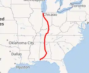
I-65 highlighted in red | |
| Route information | |
| Length | 887.30 mi[1] (1,427.97 km) |
| Existed | 1958–present |
| Major junctions | |
| South end | |
| |
| North end | |
| Location | |
| States | Alabama, Tennessee, Kentucky, Indiana |
| Highway system | |

Route description
| mi[1] | km | |
|---|---|---|
| AL | 366.22 | 590.63 |
| TN | 121.71 | 195.87 |
| KY | 137.32 | 221.00 |
| IN | 261.27 | 420.47 |
| Total | 887.30 | 1427.97 |
Alabama
In the state of Alabama, I-65 passes through or near four of the state's major metropolitan areas: Mobile, Montgomery, Birmingham, and Huntsville. I-65 begins its path northward in Mobile at its junction with I-10. From I-10, I-65 runs west of downtown Mobile and through the northern suburbs of the city before turning northeasterly towards Montgomery. In Montgomery, I-65 connects with the southern terminus of I-85. In Birmingham, I-65 has an interchange with I-20/I-59. North of downtown, I-22 branches off I-65 towards Memphis. From Birmingham, I-65 continues north, crossing the Tennessee River near Decatur. A few miles north of the river, it interchanges with I-565, a short spur route which provides access to Huntsville. It then continues northwards out of the Tennessee Valley to the state of Tennessee, towards Nashville.
Tennessee

I-65 enters Tennessee from the south near the town of Ardmore and passes through mostly rural territory for 65 miles (105 km). It then passes Lewisburg. Then it passes close to Columbia and crosses Saturn Parkway, which brings travelers to the town of Spring Hill. I-65 then continues on to reach I-840 and progresses until it intersects SR 96 at Franklin. Then the highway goes through Brentwood, Nashville, Madison, Goodlettsville, White House, and then close to Portland, it crosses into the state of Kentucky at milepost 120.5.
Kentucky

I-65 enters the state five miles (8.0 km) south of Franklin. Throughout its length, it passes near Mammoth Cave National Park, Bernheim Forest, the National Corvette Museum and the Fort Knox Military Reservation.
The first major intersection in the state is with I-165 (former Natcher Parkway) at Bowling Green. I-65 has intersections with three of the parkways in the state. The first major junction is with the Cumberland Parkway near Rocky Hill. At Elizabethtown, it has two more parkway interchanges with the Wendell H. Ford Western Kentucky Parkway and the Martha Layne Collins Bluegrass Parkway. I-65 also has interchanges with I-265, I-264, I-64, and I-71.
The widest stretch of Interstate 65 in its entirety is in Louisville at Kentucky Route 1065 (KY 1065, Outer Loop), where the main line is 14 lanes wide. The highway crosses the Ohio River into Indiana on a toll bridge. The southbound side is called the John F. Kennedy Memorial Bridge (southbound) and the northbound side is called the Abraham Lincoln Bridge. The latter bridge opened in October 2016 as part of the Ohio River Bridges Project. Prior to the project, the John F. Kennedy Memorial Bridge (completed in 1963) carried traffic in both directions. The project also included reconstruction of the I-65/I-64/I-71 convergence interchange just south of the Kennedy Bridge, plus renovating the older span to carry six lanes of southbound traffic. Additionally, a second six-lane cable-stayed bridge 12 miles (19 km) upstream on the Ohio, the Lewis and Clark Bridge, was built as part of the project, opening in December 2016 to complete the I-265 loop around Louisville.
At one time, the sixty-five-mile stretch of I-65 from Louisville to Elizabethtown was a toll road, called the Kentucky Turnpike. The bonds that financed the road have been paid off, and tolls are no longer collected. All signs of the former turnpike have been removed.
On November 15, 2006, the stretch of I-65 from Bowling Green to Louisville was renamed the Abraham Lincoln Memorial Expressway.
On February 12, 2007, a bill passed the Kentucky Senate to rename I-65 in Jefferson County the Dr. Martin Luther King Jr. Expressway.[2] Signs were posted July 25, 2007.[3]
On July 15, 2007, Kentucky highway officials raised the speed limits on most Interstate and State Parkway highways to 70 miles per hour (110 km/h). Prior to that, Kentucky was the only state along I-65 that had a maximum speed limit of 65 mph (105 km/h).
Indiana
I-65 enters Indiana at Jeffersonville and Clarksville. Miles 0–9 were rebuilt, widened and realigned from north of Sellersburg to the Ohio River during 2008–10, giving great traffic relief to the fast-growing Indiana suburbs of Louisville. Over 300,000 of the 1.5 million persons in Louisville's CMSA live in its Indiana counties.
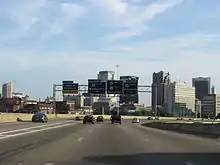
A section of I-65 in downtown Indianapolis runs concurrent with I-70. The junctions are often referred to as the "North Split" and the "South Split", forming a section of Interstate locally known as the "Inner Loop" or "The Spaghetti Bowl" due to the visual complexity of the intersecting ramps and overpasses.
In mid-March 2007, a 6-mile (9.7 km) section of I-70 from the North Split to I-465 east of downtown was restricted to automobiles only for the "Super 70" project, a massive rebuild and expansion of that freeway.[4] Trucks over 13 short tons (12 t) were forced to divert through I-65 if coming from the north and use the circular I-465 to the south to reconnect to I-70 eastbound. Westbound traffic from I-70 was required to loop north or south along I-465 to get to I-65 or I-70. The Super 70 project was completed in November 2007.
In the middle of 2003, the portion of I-65 that runs concurrently with I-70 was closed to all traffic due to the "HyperFix" project. During that time, a new concrete surface was installed and the overpasses were upgraded.
In 1999, the 25-mile (40 km) segment of I-65 between the two I-465 interchanges was renamed the Kenneth "Babyface" Edmonds Highway.
North of Lafayette near Brookston, the road passes through the Meadow Lake Wind Farm for several miles, with the turbines and standards spaced out in order to avoid a collapse onto the highway. The Fowler Ridge Wind Farm is also visible on both sides of the highway.
From its crossing into Lake County, Indiana, over the Kankakee River to its northern terminus, the highway is known as the Casimir Pulaski Memorial Highway.
Prior to 2004, the northern terminus of Interstate 65 was only 1⁄8 mile (0.20 km) north of I-90 (Indiana Toll Road). Traffic going from I-90 to I-65 had to stop at a traffic signal to make a left turn. Traffic from I-65 to I-90 bypassed the traffic signal via an isolated right-turn lane. In 2004, the interchange was fully grade-separated, so it is now one interchange involving I-65, I-90, US 12, and US 20, thereby eliminating a connection gap in the Interstate Highway system.
Junction list
- Alabama
 I-10 in Mobile
 US 90 in Mobile
 US 98 in Mobile
 US 45 in Prichard
 I-165 in Prichard
 US 43 north-northeast of Satsuma
 US 84 west-southwest of Evergreen
 US 31 on the Hope Hull–Montgomery line
 US 80 in Montgomery. The highways travel concurrently through Montgomery.
 US 80 / US 82 in Montgomery. I-65/US 82 travels concurrently to Prattville.
 I-85 in Montgomery
- US 31 north of Prattville
- US 31 in Clanton
- US 31 in Calera
- US 31 in Alabaster
 I-459 in Hoover
- US 31 on the Hoover–Vestavia Hills city line

 US 11 / US 78 in Birmingham
 I-20 / I-59 in Birmingham
- US 31 in Birmingham
 I-22 in Fultondale
- US 31 in Smoke Rise. The highways travel concurrently through Smoke Rise.
 US 278 in Cullman
- US 31 south-southeast of Lacon
 I-565 on the Decatur–Huntsville city line
 US 72 in Athens
- US 31 in Athens. The highways travel concurrently to Ardmore, Tennessee.
- Tennessee
 US 64 west of Frankewing
 US 412 in Columbia
 I-440 in Nashville
 I-40 in Nashville. The highways travel concurrently through Nashville.

 US 70 / US 70S / US 431 in Nashville
- US 70 in Nashville
 I-24 in Nashville. The highways travel concurrently through Nashville.
- US 431 in Nashville

 US 31W / US 41 in Nashville
- US 31W / US 41 in Goodlettsville
- Kentucky
- US 31W south-southeast of Franklin
- I-165 in Bowling Green
 US 231 in Bowling Green
 US 68 in Oakland
- US 31W in Munfordville
- US 31W in Elizabethtown
 US 62 in Elizabethtown
 I-265 in Louisville
 I-264 in Louisville
 US 150 in Louisville
 I-64 /
  I-71 in Louisville
- Indiana
- US 31 in Jeffersonville. The highways travel concurrently to west of Jeffersonville.
- I-265 in Clarksville
- US 31 south-southeast of Crothersville
 US 50 in Seymour
- US 31 in Taylorsville


 I-74 / I-465 / US 31 / US 36 / US 40 in Indianapolis
 I-70 in Indianapolis. The highways travel concurrently through Indianapolis.
- I-465 in Indianapolis

 I-865 / US 52 north-northwest of Royalton. I-65/US 52 travels concurrently to Lebanon.
- US 231 south of Wolcott
 US 24 / US 231 east of Remington
- US 231 north of Remington
- US 231 in Crown Point
 US 30 in Merrillville

 I-80 / I-94 / US 6 in Gary
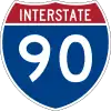 I-90 in Gary
 US 12 / US 20 in Gary
Auxiliary routes
- I-165, serving the Alabama communities of Pritchard and Mobile
- I-565, a spur in Alabama that begins in Decatur and ends in Huntsville
- I-165, a spur in Kentucky that begins in Bowling Green and ends in Owensboro
- I-265, the beltway around the Louisville area in Kentucky and Indiana. In Kentucky, the highway is called the Gene Snyder freeway, and the Lee H. Hamilton Highway in Indiana
- I-465, a full beltway around Indianapolis
- I-865, a connection between I-65 and I-465 on the northwest side of Indianapolis, formerly numbered I-465
See also
- Ohio River Bridges Project
- Super Bowl XLI, dubbed the "I-65 Bowl" due to the proximity of the competing teams' cities (Indianapolis and Chicago) to I-65
References
- Adderly, Kevin (January 15, 2014). "Table 1: Main Routes of the Dwight D. Eisenhower National System of Interstate and Defense Highways as of December 31, 2013". Route Log and Finder List. Federal Highway Administration. Retrieved November 30, 2014.
- Gerth, Joseph (February 13, 2007). "Senate OKs renaming I-65 for King". The Courier-Journal. Louisville, KY.
- Shafer, Sheldon S. (July 25, 2007). "Mayor, Democrats back I-65 King plan". The Courier-Journal. Louisville, KY. Retrieved July 30, 2007.
- "Super 70". in.gov. Archived from the original on October 29, 2007.
External links
 Media related to Interstate 65 at Wikimedia Commons
 Geographic data related to Interstate 65 at OpenStreetMap
| Signed | |
|---|---|
| Unsigned | |
| Lists | |
| Other | |
Major Interstates highlighted | |