Ernakulam district
Ernakulam (IPA: /eːrɐɳaːkʊɭɐm/; IAST: Eṟaṇākuḷaṁ, in Malayalam: എറണാകുളം) is a district of Kerala, India, that takes its name from the eponymous city division in Kochi. It is situated in the central part of the state, spans an area of about 3,000 square kilometres (1,200 sq mi), and is home to over 9% of Kerala's population. Its headquarters are located at Kakkanad. The district includes Kochi, also known as the IT and commercial capital of Kerala, which is famous for its ancient Hindu temples, churches, and mosques. The district includes the largest metropolitan region of the state: Greater Cochin. Ernakulam is the district that yields the most revenue and the largest number of industries in the state. It contributes to around 60% of the annual state revenue,[4] and is the third most populous district in Kerala, after Malappuram and Thiruvananthapuram (out of 14 districts).[5] The district also hosts the highest number of international and domestic tourists in Kerala state.
Ernakulam district | |
|---|---|
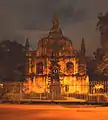
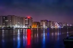 Kochi city skyline during night | |
|
Location in Kerala, India | |
| Coordinates: 10.00°N 76.33°E | |
| Country | |
| State | Kerala |
| Named for | Rishinagakulam |
| Headquarters | Kakkanad, Thrikakkara Municipality |
| Government | |
| • Collector | S Suhas, IAS |
| • Commissioner (Kochi) | Vijay Sakhare, IPS |
| • S.P (Ernakulam Rural) | K.Karthik, IPS |
| • DFO | A. Renjan, IFS |
| Area | |
| • Total | 3,063 km2 (1,183 sq mi) |
| Area rank | 4 |
| Population (2018) | |
| • Total | 3,427,659[2] |
| • Density | 1,119/km2 (2,900/sq mi) |
| Languages | |
| • Official | Malayalam, English |
| Time zone | UTC+5:30 (IST) |
| ISO 3166 code | IN-KL-KO, IN-KL |
| Vehicle registration | KL-07, KL-17, KL-39, KL-40, KL-41, KL-42, KL-43, KL-44, KL-63 |
| HDI (2005) | |
| Website | ernakulam |
The most commonly spoken language in Ernakulam is Malayalam. English is widely used, mostly in business circles. Ernakulam became India's first district to have 100 percent banking or full "meaningful financial inclusion" in 2012.[6][7]
Ernakulam has a very high Human Development Index of 0.801 (UNHDP report 2005), which is among the highest in India.[8]
Etymology
The name Ernakulam is derived from Erayanarkulam (Tamil/Malayalam) which means 'the abode of Lord Shiva'.[9] Ernakulam was also known as Rishinagakulam in ancient times.
History

Ernakulam has played a part in the political history of south India since ancient times. The Jews, Syrians, Arabs, Chinese, Dutch, British, and Portuguese seafarers followed the sea route to the Kingdom of Cochin and left their impressions on the town. In 1896, the Maharaja of Cochin initiated local administration by forming a town council in Ernakulam. Initially, The district's headquarters were located in the portion of the city known as Ernakulam, which gave the district its name; the headquarters was relocated afterwards to Kakkanad.
In the year 1998, Kuttampuzha village was added to the district from Idukki district following which the district got a political boundary with neighbouring state of Tamil Nadu. There is no interstate road that connects the district with the neighbouring state through this border.
Geography
The Ernakulam district covers an area of 3,068 km2 on the Western Coastal Plains of India. It is surrounded by the Thrissur District to the north, the Idukki District to the east, Alappuzha and Kottayam districts to the south, the Coimbatore District to the north-east and the Laccadive Sea to the west. The district is divided geographically into highland, midland, and coastal area. The altitude of the highlands is about 300 m. The Periyar River, Kerala's longest, flows through all the taluks except Muvattupuzha. The Muvattupuzha River and a branch of the Chalakkudy River also flow through the district. The average yearly rainfall in the district is 3,432 mm. The district has a moderate climate and mostly falls within the Malabar Coast moist forests ecoregion, while the highlands are part of the South Western Ghats moist deciduous forests ecoregion. Many types of sands, soil, and rocks are abundant here. Cochin International Airport is located in the northern part of the district at Nedumbassery village in Angamaly.
Topography
The district is divided into three parts: lowland, midland, and the highland that consist of seaboard, plains, and hills and forests respectively. 20 percent of the total area are lowlands. The midland consists mainly of plain land and a group of islands that naturally drain water via backwaters and canals. The hilly or eastern portion is formed by a section of the Western Ghats. Muvattupuzha and Kothamangalam taluks, which were initially parts of the Kottayam district and constitute the highlands. Muvattupuzhayar and Periyar are the main rivers, of which the latter flows through Muvattupuzha, Aluva, Kunnathunad and Parur taluks. During the rainy season these rivers are full and heavy floods affect the low-lying areas on the banks, but in the summer season, they generally go dry and narrow. The Periyar is stretched over a length of 229 km.
Forest and wildlife

The flora of this district is tropical. The heavy rainfall combined with moderate temperatures and fertile soil support abundant vegetation. Many of the common plants are found in the coastal area, which forms the lowland region. The midland region is occupied by coconut palms, paddy, tapioca, pepper, pineapple and pulses. The lower slopes of the highland region have teak and rubber.
Mangalavanam Bird Sanctuary
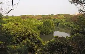
Mangalavanam Bird Sanctuary is located at the centre of Kochi. It covers 2.74 ha (6.8 acres),[10] supports many species of mangroves and is a nesting ground for a variety of migratory birds. The Managalavanam is called the "green lung of Kochi",[11] considering its role in controlling the city's air pollution.[12]
Thattekad Bird Sanctuary
Thattekad Bird Sanctuary lies on the northern bank of the Periyar River and covers about 25 km2 (10 sq mi). It was founded by ornithologist Salim Ali. The sanctuary is 80 km (50 mi) from Kochi. Birds found here include falcons, jungle fowl, water hens, and hornbills. The flora of this area consists mainly of plantations of teak, rosewood, and mahogany.
Climate
| Climate data for Kochi | |||||||||||||
|---|---|---|---|---|---|---|---|---|---|---|---|---|---|
| Month | Jan | Feb | Mar | Apr | May | Jun | Jul | Aug | Sep | Oct | Nov | Dec | Year |
| Record high °C (°F) | 35 (95) |
37 (99) |
37 (99) |
34 (93) |
35 (95) |
33 (91) |
35 (95) |
35 (95) |
38 (100) |
35 (95) |
34 (93) |
33 (91) |
38 (100) |
| Average high °C (°F) | 30 (86) |
31 (88) |
31 (88) |
31 (88) |
31 (88) |
28 (82) |
28 (82) |
28 (82) |
28 (82) |
29 (84) |
30 (86) |
30 (86) |
30 (86) |
| Average low °C (°F) | 23 (73) |
25 (77) |
26 (79) |
26 (79) |
26 (79) |
25 (77) |
24 (75) |
24 (75) |
25 (77) |
25 (77) |
25 (77) |
23 (73) |
25 (77) |
| Record low °C (°F) | 17 (63) |
18 (64) |
20 (68) |
21 (70) |
22 (72) |
21 (70) |
21 (70) |
20 (68) |
22 (72) |
20 (68) |
20 (68) |
19 (66) |
17 (63) |
| Average precipitation mm (inches) | 21.9 (0.86) |
22.9 (0.90) |
35.3 (1.39) |
124.0 (4.88) |
395.7 (15.58) |
720.7 (28.37) |
697.2 (27.45) |
367.8 (14.48) |
289.4 (11.39) |
302.3 (11.90) |
175.1 (6.89) |
48.3 (1.90) |
3,228.3 (127.10) |
| Source 1: [13] | |||||||||||||
| Source 2: [14] | |||||||||||||
Economy
Ernakulam is the richest district in Kerala in terms of GDP and per capita income, contributing around 60% towards the total state revenue, and is the biggest commercial centre in the state of Kerala. Its M.G. Road is the location of some of the biggest businesses in Kerala. Kochi is also the headquarters of some large companies like Federal Bank, Geojit, BC to AD, V-Guard, and Muthoot.
The sea along the entire coast of the district and its backwaters are the habitat of various kinds of fish that supply both marine and inland fisheries.
Agriculture
The eastern part of Ernakulam is primarily agrarian in nature. Rice is the principal crop cultivated in the wetlands. The district is the largest producer of nutmeg and pineapple in the state: more than 55% of pineapples produced in the state is cultivated in the district. Rubber is the most cultivated plantation crop in the district and the district is the second-largest producer of rubber in the state behind Kottayam. Other important crops cultivated in the district are tapioca, black pepper, areca nut, coconut, turmeric, banana, and plantain.
Education
Ernakulam is the first district in India to have 100 percent literacy by 1990. Pothanikkad is the first village in India that achieved 100 percent literacy according to state literacy programme is in this district.
There are three prominent universities in Ernakulam: Sree Sankaracharya University of Sanskrit in Kalady, Cochin University of Science and Technology in Kalamassery, and Kerala University of Fisheries and Ocean Studies in Kochi. The district has the most number of educational institutions in the state; as of 2019, there are 476 fully high-tech schools in Ernakulam.[15]
In 2017, Ernakulam district administration launched the Roshni project, which aims to provide Malayalam education to migrant children. It supported 1,265 migrant workers’ children from lower primary to high school.[16]
Divisions
There are two revenue divisions: Fort Kochi and Muvattupuzha. The municipal corporation is in Kochi.
Taluks
The district has the most taluks in the state. The district is divided by two revenue divisions with 7 taluks.
Municipalities
Ernakulam district has the greatest number of municipalities in the state.
Parliamentary Constituencies
- Ernakulam Parliamentary Constituency
- Chalakudy Parliamentary Constituency (partially)
- Idukki Parliamentary Constituency (parts of Muvattupuzha taluk and Kothamangalam taluk)
- Kottayam Parliamentary Constituency (parts of Muvattupuzha taluk and Kanayannur taluk)
Assembly Constituencies
Demographics
| Year | Pop. | ±% p.a. |
|---|---|---|
| 1901 | 646,235 | — |
| 1911 | 735,267 | +1.30% |
| 1921 | 789,311 | +0.71% |
| 1931 | 982,731 | +2.22% |
| 1941 | 1,172,292 | +1.78% |
| 1951 | 1,393,679 | +1.74% |
| 1961 | 1,702,740 | +2.02% |
| 1971 | 2,170,820 | +2.46% |
| 1981 | 2,549,255 | +1.62% |
| 1991 | 2,840,279 | +1.09% |
| 2001 | 3,105,798 | +0.90% |
| 2011 | 3,282,388 | +0.55% |
| 2018 | 3,427,659 | +0.62% |
| source:[17] | ||
According to the 2018 Statistics Report, Ernakulam has a population of 3,427,659.[2] The 2011 Census of India reports that the district is ranked 104th most populous in India out of 640.[5] The district has a population density of 1,072 inhabitants per square kilometre (2,780/sq mi).[5] Its population growth rate in 2001–2011 was 5.69%.[5] Ernakulam has a sex ratio of 1027 females for every 1000 males,[5] and a literacy rate of 95.89%.[5]
This district is listed as the "most advanced" district in Kerala. It had a resident population of 3,105,798 as of 2001, excluding the commuters from neighbouring districts. The urban population is 68%.[18]
Religion
Hindus (46%) accounts for the largest community, followed by Christians (38%) and Muslims (15.7%). A small population of Jains, Jews, and Sikhs reside in Kochi.[20]
Ernakulam also has a significant Konkani Hindu population who escaped from Goa during the Goa Inquisition.[21] There is a small Jain community in Ernakulam district, concentrated mainly in the Kochi city.[22] The Sikh community in Ernakulam is also concentrated mainly in Kochi. There are more than 25 Sikh families in Kochi and there is one gurdwara.[23]
Culture
Festivals and traditions
The Aluva Sivarathri festival at the Aluva Mahadeva Temple (situated on the banks of river Periyar) in Aluva attracts people from around the country.
St. Mary's Orthodox Syrian Cathedral, Piravom is believed to be founded in 405 A.D. and was the headquarters of Archdeacon and St Thomas until the 18th century.
Adi Shankaracharya was born in Kalady, which is considered to be a major pilgrimage centre for Hindus around the world.
Kallil Kshethram is a famous Jain temple near Perumbavoor.
Puthencruz is the regional seat of Syriac Orthodox Church in India, and is where Saint Thomas Syro-Malabar Catholic Church, Malayattoor is located.
The eight-day lent (Ettunombu) festival at St Mary's Jacobite Syrian Valiyapally, Thamarachal attracts many people from all over the state. St. George Orthodox Syrian Church at Kadamattam near Muvattupuzha is very old and was founded by Mar Abo Syrian Metropolitan in the 5th century A.D. He brought a cross from Persia, which is preserved in the church. The festival at the Latin church of Vallarpadam on 24 September attracts people belonging to all religions. The icon of Virgin Mary in this church is credited with many miracles. St. George's Syro-Malabar Catholic Forane Church, Edappally was founded in 593 A.D.
Important pilgrimage sites in Ernakulam are Koonan Kurish St George Orthodox Pilgrim church, Mattancherry; Vadakken Paravoor St Thomas Catholic Church, Malayattoor Pally; and Mor Thoman Jacobite Church, Kothamangalam; and Thrikkunnathu St Mary's Seminary Church, Aluva. The relics of Gregorios Abdul Jaleel are preserved at the St. Thomas Jacobite church North Paravur. Thousands of pilgrims from Kerala culminate on 27 April for the Dhukrono of the Saint. The Feast of Eldho Mor Baselios is celebrated in the tomb church Mor Thoman Church at Kothamangalam every year on 2 and 3 October. The Feast of Paulose Mar Athanasius on 26 January at Thrikkunnathu St Mary's Seminary Church, Aluva, where he is entombed, also attracts thousands.
Gheevarghese Mar Gregorios of Parumala, also known as Parumala Thirumeni, the first saint of Malankara Orthodox Syrian Church from India was born and brought up in Mulanthuruthy.
Places of interest
- Marine Drive, Kochi
- Cochin Jewish Synagogue: Constructed in 1567, oldest active synagogue in the Commonwealth of Nations
- Chinese Fishing Nets (Cheena Vala)
- Hill Palace, Tripunithura
- Bolgatty Island
- Willingdon Island
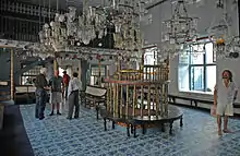
- Dutch Palace: Made in 1568 by the Portuguese. Later re-structured by the Dutch.
- St. Francis Church, Kochi: Originally built in 1503, the oldest European church in India
- Kodanad: Elephant training centre is located here.
- Pareekshit Thampuran Museum
- Kerala Historical Museum: Located at Edappally
- Chendamangalam, a village
- Palium Palace
- Vypeenakotta Seminary
- Bhoothathankettu, a scenic dam site
- St. Thomas Syro-Malabar Catholic Church, Malayattoor: The only international shrine in Asia. Believed to have been visited by St. Thomas, the apostle.
- Wonder La, Kakkanad: Amusement park
- Cherai Beach.
- Kuzhippilly Beach[24]
- Fort Kochi Beach
- Paniyeli Poru
- Ezhattumugham
Transport
Road connectivity
The three major national highways passing through Ernakulam are the Cochin-Mumbai Highway (NH 66), Salem-Kanyakumari (NH 47 part of NSEW corridor), and Cochin-Dhanushkodi highway (NH 49).
Railway station
Ernakulam has 17 railway stations. The Ernakulam Junction, Ernakulam Town and Aluva are the major stations. The other stations are Angamaly, Thripunithura, Edapally, Mulamthuruthy, Cochin Harbour Terminus, Karakutty, Chowara, Kalamassery, Nettoor, Kumbalam, Mattancherry H., Chottanikkara road, and Piravom road. The rail routes travel via Thrissur, Kottayam, Cochin H.T., Alappuzha, and Vallarpadam. The Angamaly-Erumely Sabarimala route passes through the district. Kochi Metro runs in Kochi.
Airport
Ernakulam district has two airports: Naval airport in W.island (Old Cochin airport) and Cochin International Airport (CIAL). CIAL is the fourth largest airport in the country after Mumbai, Delhi, and Chennai, and serves International passengers.
Water transport
Ernakulam lies in the flat delta region of the Periyar and Moovattupuzha rivers. Water transport is prominent in the district via rivers and lagoons.
Notable people
- Adi Sankaracharya (Saint Advaita)
- Ajay Kudua (cricketer)
- Swami Chinmayananda (Indian spiritual leader and geetacharya )
- Geevarghese Mar Gregorios of Parumala (Syrian Orthodox Saint)
- Paulose Mar Athanasius (Syrian Orthodox Saint)
- Shadkala Govinda Marar (Carnatic musician)
- Sahodaran Ayyappan (social reformer and former minister of Kochi State)
- K J Yesudas (singer)
- Changampuzha (poet)
- Malayattoor ramakrishnan (novelist)
- NS Madhavan (writer)
- Sebastian Paul (politician)
- Simon Britto (politician)
- Feroze V Rasheed (cricketer)
- K Jayaraman (cricketer)
- G. Sankara Kurup (poet)
- P K Vasudevan Nair (former chief minister)
- Balachandran Chullikad (poet and actor)
- Sreesanth (cricketer)
- K. V. Thomas (politician)
- Asin Thottumkal (actress)
- Jayasurya (actor)
- Cochin Haneefa (actor)
- Sreejesh Ravindran (hockey player)
- Sankaradi (actor)
- Salim Kumar (actor)
- T. K. Narayana Pillai (former chief minister of Kerala)
- Jayaram (actor)
- Lalu Alex (actor)
- Hibi Eden (politician)
- K. M. George (politician)
- Francis George (politician)
- Johnny Nellore (politician)
- T. M. Jacob (politician)
- Anoop Jacob (politician)
- Jose Thettayil (politician)
- Nivin Pauly (actor)
- Lal (actor)
- Rajeev Ravi (director and cinematographer)
Gallery
 Chinese Net Bridge at Marine Drive walkway
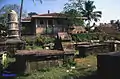 The old Dutch cemetery in Kochi
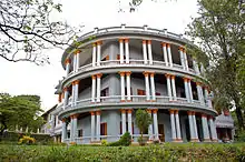
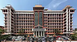
 Heritage Building of Ernakulam District Court
References
- "Demography -Ernakulam" (PDF). Directorate of Census Operations, Kerala. Retrieved 4 July 2020.
- Annual Vital Statistics Report - 2018 (PDF). Thiruvananthapuram: Department of Economics and Statistics, Government of Kerala. 2020. p. 55.
- "UNHDP - Kerala Report".
- Pilgrimate to Temple Heritage 2019: Ernakulam district temples. Info Kerala Communications Pvt Ltd, 2019. 2019. ISBN 9788193456781. Retrieved 2 October 2020.
- "District Census 2011". Census2011.co.in. 2011. Retrieved 30 September 2011.
- "Ernakulam to be declared first district with 100% banking". The Hindu Businessline. 15 November 2012. Archived from the original on 1 February 2013. Retrieved 27 February 2013.
- Soundarapandian, Mookkiah (2000). Literacy Campaign in India. New Delhi: Discovery Publishing House. p. 21. ISBN 9788171415533.
- "Kerala". UNDP in India. Retrieved 10 October 2019.
- "A STUDY ON COMMUNITY TOURISM AND ITS IMPACT IN KERALA WITH SPECIAL REFERENCE TO ERNAKULAM DISTRICT" (PDF). Archived from the original (PDF) on 30 August 2019. Retrieved 27 February 2013.
- "Mangalavanam Bird Sanctuary". Kerala Tourism Development Corporation. Retrieved 21 January 2018.
- "Green Lung of Kochi". cochin.org. Retrieved 3 April 2016.
- "Mangalavanam Bird Sanctuary". Kochi Servnet. Retrieved 12 November 2015.
- "Kochi, India". Whetherbase. August 2011. Retrieved 1 July 2010.
- "Kochi, India". MSN India. Archived from the original on 14 July 2011. Retrieved 3 August 2010.
- https://www.thehindu.com/news/cities/Kochi/now-ernakulam-has-476-fully-high-tech-schools/article30226214.ece
- https://scroll.in/article/934120/in-keralas-ernakulam-district-a-programme-is-helping-migrant-children-stay-in-school
- Decadal Variation In Population Since 1901
- censusindia.gov.in
- "Religion – Kerala, Districts and Sub-districts". Census of India 2011. Office of the Registrar General.
- Official Ernakulam District Profile Archived 21 July 2011 at the Wayback Machine
- https://www.newindianexpress.com/cities/kochi/2017/oct/18/exploring-kochi-through-a-goan-lens-1677623.html
- https://m.timesofindia.com/city/kochi/Jain-festival-celebrated-in-city/articleshow/54386779.cms
- https://m.timesofindia.com/city/kochi/The-Sikhs-here-love-Kochi/articleshow/16961391.cms
- http://www.kuzhupillybeach.com/
External links
| Wikimedia Commons has media related to Ernakulam district. |
Places adjacent to Ernakulam district | |
|---|---|