Taliparamba
Taliparamba (also known as Perinchelloor and Lakshmipuram) is a Municipality in Taliparamba taluk of Kannur district, Kerala, India. The municipal town spreads over an area of 25.04 square kilometres (9.67 sq mi) and is inhabited by 44,247 people.[5]
Taliparamba
Perinchelloor, Lakshmipuram | |
|---|---|
 Kuppam River | |
 Taliparamba Location in Kerala | |
| Coordinates: 12.0368°N 75.3601°E | |
| Country | |
| State | Kerala |
| District | Kannur |
| Region | North Malabar |
| Municipality Established | 1990 |
| Government | |
| • Type | Municipality |
| • Body | Taliparamba Municipality |
| • Municipal Chairman | Allamkulam Mahamood |
| • Sub Collector | S. Ilakya IAS |
| • Deputy Superintendent of Police | T K Rathnakumar |
| • MLA | James Mathew |
| • MP | K. Sudhakaran |
| Area | |
| • Total | 25.04 km2 (9.67 sq mi) |
| Elevation | 49 m (161 ft) |
| Population (2011)[3] | |
| • Total | 44,247 |
| • Density | 1,800/km2 (4,600/sq mi) |
| Languages | |
| • Official | Malayalam, English |
| Time zone | UTC+5:30 (IST) |
| PIN | 670141 |
| Telephone code | 0460 |
| Vehicle registration | KL-59 |
| Sex ratio | 1187 ♂/♀ |
| Literacy | 96% |
| Taluk | Taliparamba |
| Assembly constituency | Taliparamba |
| Lok Sabha constituency | Kannur |
| Climate | Tropical rainforest (Köppen:Af)[4] |
| Website | www |
Etymology
The town's name may be derived from "Tali" (plate) and "Parambu" (area), and from the legend of Rajarajeshwara Temple. According to this legend, the Ikshvaku King Maandhatha offered great penance to Shiva who in return gifted him with a Shiva Linga and instructed him to place it at a site where there had never been a cremation ground. He found a space the size of a plate in Perinchelloor, and hence the name Taliparamba became attached to the area. Lakshmipuram, a previous name for the city, means place of prosperity. It is best known as the location of Allamkulam (Mahshood).
History
Taliparamba originated as the Perinchalloor Brahmin settlement. Of the 2,000 Brahmin families who settled here, only 45 remain today, as many were forced to flee after the onslaught of the Islamist army of Tipu Sultan in the late 18th century. In 1955 the Taliparamba panchayat was formed, with Balakrishna Menon as its first president. In 1975 the Pattuvam region was separated from the panchayat. In 1990 Taliparamba municipality was formed by the merging of Anthoor and Taliparamba panchayats and then bifurcated Anthoor region from Taliparamba and created separate Anthoor municipality in 2015.
Location
Taliparamba is located about 22 kilometres (14 mi) north of the district headquarters of Kannur, and about 486 kilometres (302 mi) away from the state capital of Thiruvananthapuram, 287 kilometres (178 mi) north of Ernakulam, 110 kilometres (68 mi) north of Kozhikode, 132 kilometres (82 mi) south of Mangalore and 310 kilometres (190 mi) south west of Bangalore city.
Administration
Taliparamba is the headquarters of Taliparamba taluk, one of the five taluks constituting the district and one of the revenue divisions in Kerala. Kannur district is divided into two revenue divisions, Taliparamba division in the north and Thalassery division in the south, respectively. The division has jurisdiction over taluks of Payyanur, Taliparamba and Kannur. Taliparamba Assembly constituency comes under Kannur Loksabha constituency.
Taliparamba Municipality is divided into 34 wards covering an area of 25 km2 (9.7 sq mi) for which the elections are held every five years. Taliparamba Municipality has total administration over 8909 houses to which it supplies basic amenities like water and sewerage. It is also authorize to build roads within Municipality limits and impose taxes on properties coming under its jurisdiction.
Constituent Villages
The headquarters of Taliparamba taluk is located in Taliparamba. There are 28 villages in the Taluk. Those villages are Alakode, Anthoor, Chelery, Chengalayi, Chuzhali, Kuttiyeri, Malappattam, Maniyoor, Mayyil, Morazha, Naduvil, Nediyanga, Panniyoor, Pariyaram, Pattuvam, Payyavoor, Sreekandapuram, Taliparamba, Udayagiri, Velladu, Thimiri, Eruvessi, Irikkur, Kayaralam, Kolacheri, Kooveri, Kurumathur, and Kuttiyattoor.
Geography
Taliparamba is located at 12.05°N 75.35°E.[6] It has an average elevation of 56 metres (184 ft) above sea level. The surrounding area (including the villages of Pattuvam, Pariyaram, Kuttiyeri, Karimbam, and Koonam) features lush green fields and low rolling hills. The Kuppam and Valapattanam rivers surround the town and the Arabian Sea is only 14 kilometres (8.7 mi) to the west of the city.
Education
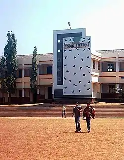
In the 14th and 15th centuries, during the regime of the Kolathiri Rajas, Taliparamba was renowned in Kerala as a seat of learning, enlightenment, and culture. Today, the most prominent educational institutions include:
- Darul Falah Islamic Academy, Taliparamba
- Pariyaram Medical College
- Government College of Engineering, Kannur
- National Institute of Fashion Technology
- Sir Syed College (Taliparamba)
- Tagore Vidyaniketan, Taliparamba
- St. Paul's High School, Taliparamba
- Seethi Sahib Higher Secondary School, Manna
- Yatheem Khana UP School, Manna
- Mappila UP School, Madrasa Junction
- Chinmaya Vidyalaya, Taliparamba
- Akkiparamba UP School, Chiravkk
- Moothedath Higher Secondary School, Taliparamba
- Shyam Prasad School, Taliparamba
- Sir Syed Higher Secondary School, Karimbam
- Devamatha Arts And Science College, Paisakary
Demographics
As of the 2011 census, Taliparamba Municipality had population of 72,465 of which 33,779 are males while 38,685 are females with an area spread over 43 km2 (17 sq mi).[7] In 2015, Anthoor region was carved from Taliparamba Municipality and formed a separate Anthoor Municipality. After bifurcation, Taliparamba Municipality has a population of 44,247 which consists of 20,838 males and 23,409 females with an area of 25.04 km2 (9.67 sq mi). The female sex ratio here is of 1187 against state average of 1084. The average population density is 1,767 inhabitants per square kilometre (4,580/sq mi).
Literacy rate of Taliparamba town is 96% higher than state average of 94.00%. In Taliparamba, male literacy is around 97.50% while female literacy rate is 93.06%. Hindus, Muslims, and Christians form the core population.[8]
Politics
The political landscape of Taliparamba is dominated by the Communist Party of India (Marxist) (CPIM). In the Kerala Legislative Assembly election held in 2016, James Mathew won by a margin of 41,000 votes.[9] Other political parties like such as the BJP, Muslim League, and Congress also have marginal influence in the town.
Taliparamba assembly constituency is part of the Kannur Lok Sabha constituency.[10]
Transportation
NH 66 passes through Taliparamba town. Goa and Mumbai can be accessed on northern side and Cochin and Thiruvananthapuram on southern side.[11] SH 36 connects Taliparamba town with Iritty and Mysore and Bangalore are accessible from Iritty towards east.
The nearest railway station is Kannur on the Shoranur-Mangalore Section line.
The nearest airport is at Kannur, 37 kilometres (23 mi) away,[12] while Mangalore and Calicut airports are nearby, too.
Tourism
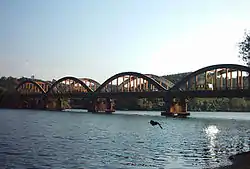
Taliparamba is home to a number of temples, churches, and mosques. Temples include the Rajarajeshwara Temple, Trichambaram Temple and Parassinikkadavu Temple. Taliparamba Juma Masjid and St. Mary's Church are other prominent religious centres in the town. The bridges at Kuttiyeri and Kooveri, Vellikkeel Eco-Tourism Park, and the riverside temple at Parassinikkadavu attract many tourists. Paithal Mala and Palakkayam thattu hill stations are other popular locations nearby.
Rajarajeshwara Temple
Rajarajeshwara Temple is one of the 108 existing ancient Shiva Temples in Kerala.[13] The temple is about 2 kilometres from Taliparamba town. The temple even draws visitors from the neighboring states of Karnataka and Tamil Nadu.[14]
The temple was subject to attack by Tipu Sultan. Remnants of the old gigantic gopuram can be found at the entrance, which was demolished by Tipu's army. One legend says that when the temple was under siege, the head priest was inside the sanctum sanctorum and prayed ceaselessly day and night. The legend says that as a result, a black snake bit the commander of the besieging army and a hooded serpent appeared before every soldier, immobilizing the army and saving the temple from total destruction.
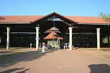
Trichambaram Temple
The Trichambaram Temple is about 3 kilometres south of Taliparamba. The famous two-week Trichambaram festival is celebrated every year at this temple. The festival celebrates the coming of Balarama from the nearby Mazhoor temple to meet his brother Sri Krishna at the temple.[15]
Kanjirangad Vaidyanatha Temple
Kanjirangad Vaidyanadtha Temple is the third important temple in Taliparambam, dedicated to the worship of Shiva. The three temples are together overseen by the TTK devaswam.
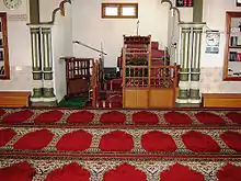
Taliparamba Juma masjid
The Taliparamba Valiya Juma masjid is inside the city's market and is built in the style of a Hindu temple. The city's main burial ground is near the masjid. The mosque's architecture features traditional Vasthu elements, while the interior demonstrates regal as well as traditional themes. The main hall, used mostly for Friday sermons, is built of wood and features large load-bearing pillars.
St. Mary’s Forane Pilgrim church
A growing immigrant population of Syrian Catholics in the area gave rise to a need for Catholic worship facilities. In 2012, construction of the St. Mary's Forane Pilgrim church was completed, which services the Taliparamba area.
Pushpagiri church
This church at Pushpagiri hills is Catholic.
Mosques
The city's mosques include Taliparamba Juma masjid, Syed Nagar mosque, Shadulipalli Market Road mosque, Yatheem Khana masjid, and Rifai Juma masjid.
 Sree Rajarajeshwara Temple
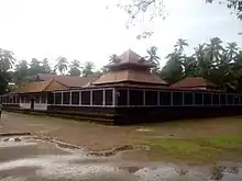 Trichambaram Sree Krishna Temple
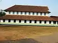 Juma Masjid
.jpg.webp) Taliparamba Shivasundaran
Taliparamba Shivasundaran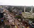 Skyview Taliparamba town
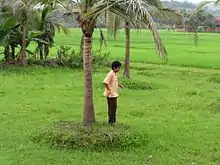
Karimbam farm
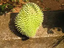
The District Agricultural Farm at Karimbam is a major research organization in Taliparamba. The farm was originally established in 1905 by Sir Charles Alfred Barber at the behest of the Madras Government, based on the recommendation of the Famine Commission of 1880 of the Government of India. Although the objective was to do research on pepper, the activities of the farm were further extended to agroclimatic experiments, hybridization and the production and distribution of seeds and seedlings. Covering an area of 56 hectares, the farm has a rich biodiversity with a variety of indigenous and exotic fruit trees, such as Mangosteen, Rambutan, and Durian.[16]
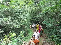 Forest footpath
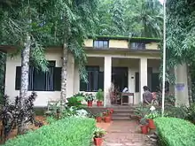 Farm Office
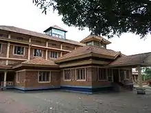 I.T.K.Center
Areas Of Taliparamba | ||||||||||
|---|---|---|---|---|---|---|---|---|---|---|
| ||||||||||
References
- https://www.kudumbashree.org ›
- https://elevationmap.net ›
- https://www.kudumbashree.org ›
- Peel, M. C.; Finlayson B. L. & McMahon, T. A. (2007). "Updated world map of the Köppen–Geiger climate classification". Hydrol. Earth Syst. Sci. 11 (5): 1633–1644. Bibcode:2007HESS...11.1633P. doi:10.5194/hess-11-1633-2007. ISSN 1027-5606. (direct: Final Revised Paper)
- https://www.trend.kerala.gov.in
- Falling Rain Genomics, Inc - Taliparamba
- https://www.citypopulation.de › php Web results Kerala (India): Districts, Cities and Towns - Population Statistics, Charts and Map
- http://www.kudumbashree.org › sub-district Web results City Profile in PMAY - Taliparamba - Kudumbashree
- http://www.elections.in/kerala/assembly-constituencies/taliparamba.html
- "Assembly Constituencies - Corresponding Districts and Parliamentary Constituencies" (PDF). Kerala. Election Commission of India. Archived from the original (PDF) on 4 March 2009. Retrieved 18 October 2008.
- https://www.thehindu.com › news Web results Nod for six-laning NH corridor - The Hindu
- https://www.thehindu.com › cities Steps to develop airport road - The Hindu
- www.nativeplanet.com › the-te... The Temple Where Women Are Allowed Only At Night – Taliparamba Sree ...
- timesofindia.indiatimes.com › city When a temple kept its doors open for Jayalalithaa | Kochi News - Times of India
- www.keralaculture.org › utsavam-tri... Utsavam of Trichambaram Sree Krishna Temple | Kerala Festivals - Kerala Culture
- www.deccanchronicle.com › ka... Karimbam: Farm born out of famine - Deccan Chronicle
External links
| Wikimedia Commons has media related to Taliparamba. |
 Taliparamba travel guide from Wikivoyage
- Map
| States/UTs | |
|---|---|
| Districts |
|
| Taluks | |
| Municipal Corporations |
|
| Municipalities |
|
| Other towns |
|
| Historical regions | |
