Kerpert
Kerpert (Breton: Kerbêr) is a commune in the Côtes-d'Armor department of Brittany in northwestern France.
Kerpert
Kerbêr | |
|---|---|
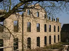 Abbey of Koad Malouen | |
Location of Kerpert 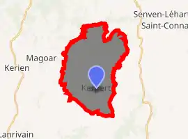
| |
 Kerpert  Kerpert | |
| Coordinates: 48°22′38″N 3°07′58″W | |
| Country | France |
| Region | Brittany |
| Department | Côtes-d'Armor |
| Arrondissement | Guingamp |
| Canton | Callac |
| Intercommunality | Pays de Bourbriac |
| Government | |
| • Mayor (2014–2020) | Jean-Paul Le Moigne |
| Area 1 | 21.00 km2 (8.11 sq mi) |
| Population (2017-01-01)[1] | 270 |
| • Density | 13/km2 (33/sq mi) |
| Time zone | UTC+01:00 (CET) |
| • Summer (DST) | UTC+02:00 (CEST) |
| INSEE/Postal code | 22092 /22480 |
| Elevation | 177–301 m (581–988 ft) |
| 1 French Land Register data, which excludes lakes, ponds, glaciers > 1 km2 (0.386 sq mi or 247 acres) and river estuaries. | |
Population
| Year | Pop. | ±% |
|---|---|---|
| 1793 | 865 | — |
| 1800 | 835 | −3.5% |
| 1806 | 1,017 | +21.8% |
| 1821 | 997 | −2.0% |
| 1831 | 1,034 | +3.7% |
| 1836 | 1,228 | +18.8% |
| 1841 | 1,241 | +1.1% |
| 1846 | 1,275 | +2.7% |
| 1851 | 1,238 | −2.9% |
| 1856 | 1,233 | −0.4% |
| 1861 | 1,255 | +1.8% |
| 1866 | 1,270 | +1.2% |
| 1872 | 1,142 | −10.1% |
| 1876 | 1,162 | +1.8% |
| 1881 | 1,153 | −0.8% |
| 1886 | 1,190 | +3.2% |
| 1891 | 1,165 | −2.1% |
| 1896 | 1,171 | +0.5% |
| 1901 | 1,203 | +2.7% |
| 1906 | 1,161 | −3.5% |
| 1911 | 1,138 | −2.0% |
| 1921 | 1,078 | −5.3% |
| 1926 | 1,018 | −5.6% |
| 1931 | 933 | −8.3% |
| 1936 | 818 | −12.3% |
| 1946 | 758 | −7.3% |
| 1954 | 596 | −21.4% |
| 1962 | 617 | +3.5% |
| 1968 | 536 | −13.1% |
| 1975 | 441 | −17.7% |
| 1982 | 407 | −7.7% |
| 1990 | 308 | −24.3% |
| 1999 | 318 | +3.2% |
| 2008 | 297 | −6.6% |
The inhabitants of Kerpert are known in French as kerpertois.
References
- "Populations légales 2017". INSEE. Retrieved 6 January 2020.
External links
| Wikimedia Commons has media related to Kerpert. |
- Base Mérimée: Search for heritage in the commune, Ministère français de la Culture. (in French)
| Authority control |
|---|
This article is issued from Wikipedia. The text is licensed under Creative Commons - Attribution - Sharealike. Additional terms may apply for the media files.