Plouguernével
Plouguernével – pronounced [pluɡɛrnevɛl] – Breton: Plougernevel – is a commune in the Côtes-d'Armor department and Brittany region of north-western France.
Plouguernével
Plougernevel | |
|---|---|
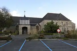 Saint Peter's church in Plouguernével | |
Location of Plouguernével 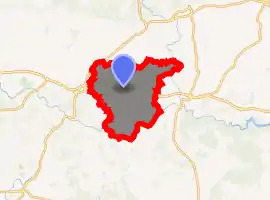
| |
 Plouguernével  Plouguernével | |
| Coordinates: 48°14′27″N 3°15′17″W | |
| Country | France |
| Region | Brittany |
| Department | Côtes-d'Armor |
| Arrondissement | Guingamp |
| Canton | Rostrenen |
| Intercommunality | Kreiz-Breizh |
| Government | |
| • Mayor (2014–2020) | Alain Guéguen |
| Area 1 | 41.60 km2 (16.06 sq mi) |
| Population (2017-01-01)[1] | 1,709 |
| • Density | 41/km2 (110/sq mi) |
| Time zone | UTC+01:00 (CET) |
| • Summer (DST) | UTC+02:00 (CEST) |
| INSEE/Postal code | 22220 /22110 |
| Elevation | 132–235 m (433–771 ft) |
| 1 French Land Register data, which excludes lakes, ponds, glaciers > 1 km2 (0.386 sq mi or 247 acres) and river estuaries. | |
Historically the town is noted for having participated in the Red Caps' Revolt (la révolte des Bonnets rouges) in 1675.
Toponymy
The meaning of the name Plouguernével is most probably to be found in the Breton words ploe (parish), kêr (town, village), and nevez (new), although an alternative suggestion is that the last two elements may be a reference to Kernev-uhel (High Cornouaille).
Population
In French the inhabitants of Plouguernével are known as plouguistes.
| Year | Pop. | ±% |
|---|---|---|
| 1946 | 2,624 | — |
| 1954 | 2,710 | +3.3% |
| 1962 | 2,653 | −2.1% |
| 1968 | 3,133 | +18.1% |
| 1975 | 3,342 | +6.7% |
| 1982 | 3,585 | +7.3% |
| 1990 | 3,255 | −9.2% |
| 1999 | 2,222 | −31.7% |
| 2005 | 1,860 | −16.3% |
| 2015 | 1,721 | −7.5% |
References
- "Populations légales 2017". INSEE. Retrieved 6 January 2020.
External links
| Wikimedia Commons has media related to Plouguernével. |
- Base Mérimée: Search for heritage in the commune, Ministère français de la Culture. (in French)
| Authority control |
|---|
This article is issued from Wikipedia. The text is licensed under Creative Commons - Attribution - Sharealike. Additional terms may apply for the media files.