Le Cambout
Le Cambout (Breton: Ar C'hembod, Gallo: Le Canbót) is a commune in the Côtes-d'Armor department of Brittany in northwestern France, within easy reach of the towns of Josselin, Loudeac, and Pontivy.[2] Smaller villages around the area include Bréhan and Plumieux.
Le Cambout
Ar C'hembod | |
|---|---|
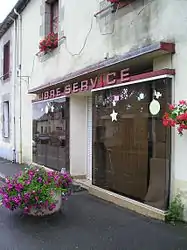 Self-service shop in Le Cambout | |
.svg.png.webp) Coat of arms | |
Location of Le Cambout 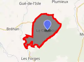
| |
 Le Cambout  Le Cambout | |
| Coordinates: 48°03′34″N 2°36′33″W | |
| Country | France |
| Region | Brittany |
| Department | Côtes-d'Armor |
| Arrondissement | Saint-Brieuc |
| Canton | Loudéac |
| Intercommunality | Loudéac |
| Government | |
| • Mayor (2014–2020) | Jean-Noël Lagueux |
| Area 1 | 18.02 km2 (6.96 sq mi) |
| Population (2017-01-01)[1] | 434 |
| • Density | 24/km2 (62/sq mi) |
| Time zone | UTC+01:00 (CET) |
| • Summer (DST) | UTC+02:00 (CEST) |
| INSEE/Postal code | 22027 /22210 |
| Elevation | 50–137 m (164–449 ft) |
| 1 French Land Register data, which excludes lakes, ponds, glaciers > 1 km2 (0.386 sq mi or 247 acres) and river estuaries. | |
The commune is divided into many smaller settlements, among them Bourg, Bas Bourg, and Tréhorel.
Amenities
The village of Le Cambout is served by a boulangerie and a tabac.
There is a church in the centre of the village and a separate, well-kept graveyard a little way off. There is a sports field to the west of the village and an area known as L’Étang de gué aux loupes which has facilities such as a lake, children's playground, camping facilities and Boules lanes. There are a number of British-owned gites in the village aimed at attracting foreign tourists to the area.[3]
Population
| Year | Pop. | ±% |
|---|---|---|
| 1962 | 625 | — |
| 1968 | 718 | +14.9% |
| 1975 | 599 | −16.6% |
| 1982 | 548 | −8.5% |
| 1990 | 549 | +0.2% |
| 1999 | 526 | −4.2% |
| 2008 | 499 | −5.1% |
Inhabitants of Le Cambout are called Cambutiades in French.
References
- "Populations légales 2017". INSEE. Retrieved 6 January 2020.
- <http://www.brittanycountrylife.com/location.html%5B%5D>
- <http://www.brittanycountrylife.com%5B%5D>
External links
| Wikimedia Commons has media related to Le Cambout. |
- Base Mérimée: Search for heritage in the commune, Ministère français de la Culture. (in French)
- Le Cambout: Village history (in French)
| Authority control |
|---|