Mellionnec
Mellionnec (Breton: Melioneg) is a commune in the Côtes-d'Armor department in Brittany in northwestern France. The chapel of La Pitié is situated in the commune.
Mellionnec
Melioneg | |
|---|---|
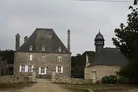 The château of Tregarantec | |
Location of Mellionnec 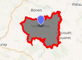
| |
 Mellionnec  Mellionnec | |
| Coordinates: 48°10′32″N 3°17′43″W | |
| Country | France |
| Region | Brittany |
| Department | Côtes-d'Armor |
| Arrondissement | Guingamp |
| Canton | Rostrenen |
| Intercommunality | Kreiz-Breizh |
| Government | |
| • Mayor (2014–2020) | Marie-Josée Fercoq |
| Area 1 | 24.22 km2 (9.35 sq mi) |
| Population (2017-01-01)[1] | 399 |
| • Density | 16/km2 (43/sq mi) |
| Time zone | UTC+01:00 (CET) |
| • Summer (DST) | UTC+02:00 (CEST) |
| INSEE/Postal code | 22146 /22110 |
| Elevation | 143–281 m (469–922 ft) |
| 1 French Land Register data, which excludes lakes, ponds, glaciers > 1 km2 (0.386 sq mi or 247 acres) and river estuaries. | |
Population
| Year | Pop. | ±% |
|---|---|---|
| 1793 | 1,120 | — |
| 1800 | 1,163 | +3.8% |
| 1806 | 1,168 | +0.4% |
| 1821 | 1,154 | −1.2% |
| 1836 | 1,255 | +8.8% |
| 1841 | 1,193 | −4.9% |
| 1846 | 1,234 | +3.4% |
| 1851 | 1,188 | −3.7% |
| 1856 | 1,210 | +1.9% |
| 1861 | 1,143 | −5.5% |
| 1866 | 1,104 | −3.4% |
| 1872 | 1,093 | −1.0% |
| 1876 | 1,117 | +2.2% |
| 1881 | 1,261 | +12.9% |
| 1886 | 1,200 | −4.8% |
| 1891 | 1,227 | +2.2% |
| 1896 | 1,252 | +2.0% |
| 1901 | 1,322 | +5.6% |
| 1906 | 1,411 | +6.7% |
| 1911 | 1,418 | +0.5% |
| 1921 | 1,407 | −0.8% |
| 1926 | 1,437 | +2.1% |
| 1931 | 1,335 | −7.1% |
| 1936 | 1,179 | −11.7% |
| 1946 | 1,148 | −2.6% |
| 1954 | 970 | −15.5% |
| 1962 | 889 | −8.4% |
| 1968 | 749 | −15.7% |
| 1975 | 628 | −16.2% |
| 1982 | 567 | −9.7% |
| 1990 | 420 | −25.9% |
| 1999 | 440 | +4.8% |
| 2008 | 405 | −8.0% |
Inhabitants of Mellionnec are called mellionnecais in French.
References
- "Populations légales 2017". INSEE. Retrieved 6 January 2020.
External links
| Wikimedia Commons has media related to Mellionnec. |
- Base Mérimée: Search for heritage in the commune, Ministère français de la Culture. (in French)
| Authority control |
|---|
This article is issued from Wikipedia. The text is licensed under Creative Commons - Attribution - Sharealike. Additional terms may apply for the media files.