Plésidy
Plésidy (Breton: Plijidi) is a commune in the Côtes-d'Armor department of Brittany in northwestern France. Inhabitants of Plésidy are called plésidiens in French.
Plésidy
Plijidi | |
|---|---|
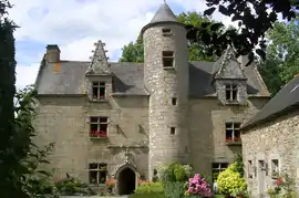 The manor of Toul-an-golet | |
Location of Plésidy 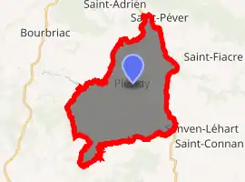
| |
 Plésidy  Plésidy | |
| Coordinates: 48°26′54″N 3°07′14″W | |
| Country | France |
| Region | Brittany |
| Department | Côtes-d'Armor |
| Arrondissement | Guingamp |
| Canton | Callac |
| Intercommunality | Pays de Bourbriac |
| Government | |
| • Mayor (2014–2020) | Guy Gautier |
| Area 1 | 25.79 km2 (9.96 sq mi) |
| Population (2017-01-01)[1] | 613 |
| • Density | 24/km2 (62/sq mi) |
| Time zone | UTC+01:00 (CET) |
| • Summer (DST) | UTC+02:00 (CEST) |
| INSEE/Postal code | 22189 /22720 |
| Elevation | 95–268 m (312–879 ft) |
| 1 French Land Register data, which excludes lakes, ponds, glaciers > 1 km2 (0.386 sq mi or 247 acres) and river estuaries. | |
Population
| Year | Pop. | ±% |
|---|---|---|
| 1793 | 1,520 | — |
| 1800 | 1,298 | −14.6% |
| 1806 | 1,317 | +1.5% |
| 1821 | 1,362 | +3.4% |
| 1831 | 1,452 | +6.6% |
| 1836 | 1,509 | +3.9% |
| 1841 | 1,520 | +0.7% |
| 1846 | 1,506 | −0.9% |
| 1851 | 1,717 | +14.0% |
| 1856 | 1,638 | −4.6% |
| 186 | 1,602 | −2.2% |
| 1866 | 1,639 | +2.3% |
| 1872 | 1,562 | −4.7% |
| 1876 | 1,585 | +1.5% |
| 1881 | 1,587 | +0.1% |
| 1886 | 1,599 | +0.8% |
| 1891 | 1,577 | −1.4% |
| 1896 | 1,579 | +0.1% |
| 1901 | 1,658 | +5.0% |
| 1906 | 1,658 | +0.0% |
| 1911 | 1,709 | +3.1% |
| 1921 | 1,520 | −11.1% |
| 1926 | 1,549 | +1.9% |
| 1931 | 1,506 | −2.8% |
| 1936 | 1,390 | −7.7% |
| 1946 | 1,115 | −19.8% |
| 1954 | 1,051 | −5.7% |
| 1962 | 956 | −9.0% |
| 1968 | 870 | −9.0% |
| 1975 | 737 | −15.3% |
| 1982 | 709 | −3.8% |
| 1990 | 636 | −10.3% |
| 1999 | 635 | −0.2% |
| 2008 | 697 | +9.8% |
Personalities
- French war hero Théophile Marie Brébant (1889-1965) was born here.
References
- "Populations légales 2017". INSEE. Retrieved 6 January 2020.
External links
| Wikimedia Commons has media related to Plésidy. |
- Base Mérimée: Search for heritage in the commune, Ministère français de la Culture. (in French)
| Authority control |
|---|
This article is issued from Wikipedia. The text is licensed under Creative Commons - Attribution - Sharealike. Additional terms may apply for the media files.