Lachaussée
Lachaussée is a commune in the Meuse department in Grand Est in north-eastern France.
Lachaussée | |
|---|---|
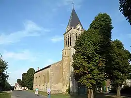 The church in Lachaussée | |
 Coat of arms | |
Location of Lachaussée 
| |
 Lachaussée  Lachaussée | |
| Coordinates: 49°02′16″N 5°49′10″E | |
| Country | France |
| Region | Grand Est |
| Department | Meuse |
| Arrondissement | Commercy |
| Canton | Saint-Mihiel |
| Intercommunality | Côtes de Meuse - Woëvre |
| Government | |
| • Mayor (2008–2014) | Gérard Peltre |
| Area 1 | 27.19 km2 (10.50 sq mi) |
| Population (2017-01-01)[1] | 271 |
| • Density | 10.0/km2 (26/sq mi) |
| Time zone | UTC+01:00 (CET) |
| • Summer (DST) | UTC+02:00 (CEST) |
| INSEE/Postal code | 55267 /55210 |
| Elevation | 203–238 m (666–781 ft) (avg. 218 m or 715 ft) |
| 1 French Land Register data, which excludes lakes, ponds, glaciers > 1 km2 (0.386 sq mi or 247 acres) and river estuaries. | |
Geography
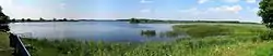
L'étang de Lachaussée
The village of Lachaussée lies on the south-eastern rim of a huge pond named Étang de Lachaussée, which was created during the middle ages from a marsh area and then devoted to pisciculture.
References
- "Populations légales 2017". INSEE. Retrieved 6 January 2020.
| Wikimedia Commons has media related to Lachaussée. |
| Authority control |
|---|
This article is issued from Wikipedia. The text is licensed under Creative Commons - Attribution - Sharealike. Additional terms may apply for the media files.