Vigneulles-lès-Hattonchâtel
Vigneulles-lès-Hattonchâtel is a commune in the Meuse department in Grand Est in north-eastern France.
Vigneulles-lès-Hattonchâtel | |
|---|---|
 Vigneulles from Hattonchâtel | |
.svg.png.webp) Coat of arms | |
Location of Vigneulles-lès-Hattonchâtel 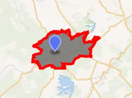
| |
 Vigneulles-lès-Hattonchâtel  Vigneulles-lès-Hattonchâtel | |
| Coordinates: 48°58′55″N 5°42′15″E | |
| Country | France |
| Region | Grand Est |
| Department | Meuse |
| Arrondissement | Commercy |
| Canton | Saint-Mihiel |
| Intercommunality | Côtes de Meuse - Woëvre |
| Government | |
| • Mayor (2008–2014) | J.C Zingerlé |
| Area 1 | 62.59 km2 (24.17 sq mi) |
| Population (2017-01-01)[1] | 1,572 |
| • Density | 25/km2 (65/sq mi) |
| Time zone | UTC+01:00 (CET) |
| • Summer (DST) | UTC+02:00 (CEST) |
| INSEE/Postal code | 55551 /55210 |
| Elevation | 212–416 m (696–1,365 ft) (avg. 259 m or 850 ft) |
| 1 French Land Register data, which excludes lakes, ponds, glaciers > 1 km2 (0.386 sq mi or 247 acres) and river estuaries. | |
The former towns of Billy-sous-les-Côtes, Creuë, Hattonchâtel, Hattonville, Saint-Benoît-en-Woëvre, and Viéville-sous-les-Côtes were joined to Vigneulles-lès-Hattonchâtel on 1 March 1973.
Gallery
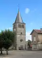 The bell tower of Vigneulles
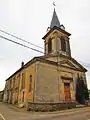 Saint-Sabastian church (Hattonville).
 Town hall
 War memorial in Vigneulles
References
- "Populations légales 2017". INSEE. Retrieved 6 January 2020.
| Wikimedia Commons has media related to Vigneulles-lès-Hattonchâtel. |
| Authority control |
|
|---|
This article is issued from Wikipedia. The text is licensed under Creative Commons - Attribution - Sharealike. Additional terms may apply for the media files.