Rupt-sur-Othain
Rupt-sur-Othain is a commune in the Meuse department in Grand Est in north-eastern France.
Rupt-sur-Othain | |
|---|---|
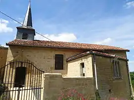 The church in Rupt-sur-Othain | |
Location of Rupt-sur-Othain 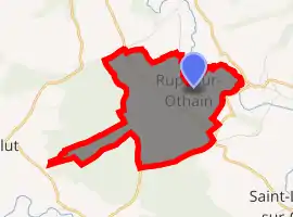
| |
 Rupt-sur-Othain  Rupt-sur-Othain | |
| Coordinates: 49°25′13″N 5°29′36″E | |
| Country | France |
| Region | Grand Est |
| Department | Meuse |
| Arrondissement | Verdun |
| Canton | Montmédy |
| Intercommunality | Communauté de communes de la région de Damvillers |
| Government | |
| • Mayor (2008–2014) | Denis Georges |
| Area 1 | 5.53 km2 (2.14 sq mi) |
| Population (2017-01-01)[1] | 44 |
| • Density | 8.0/km2 (21/sq mi) |
| Time zone | UTC+01:00 (CET) |
| • Summer (DST) | UTC+02:00 (CEST) |
| INSEE/Postal code | 55450 /55150 |
| Elevation | 207–281 m (679–922 ft) (avg. 207 m or 679 ft) |
| 1 French Land Register data, which excludes lakes, ponds, glaciers > 1 km2 (0.386 sq mi or 247 acres) and river estuaries. | |
Geography
The village lies on the left bank of the Othain, which forms most of the commune's north-eastern border.
See also
References
- "Populations légales 2017". INSEE. Retrieved 6 January 2020.
| Wikimedia Commons has media related to Rupt-sur-Othain. |
| Authority control |
|---|
This article is issued from Wikipedia. The text is licensed under Creative Commons - Attribution - Sharealike. Additional terms may apply for the media files.