Broussey-Raulecourt
Broussey-Raulecourt is a commune in the Meuse department in Grand Est in northeastern France.
Broussey-Raulecourt | |
|---|---|
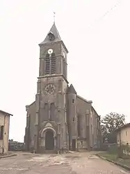 The church in Broussey | |
.svg.png.webp) Coat of arms | |
Location of Broussey-Raulecourt 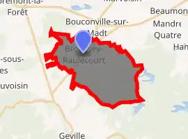
| |
 Broussey-Raulecourt  Broussey-Raulecourt | |
| Coordinates: 48°49′31″N 5°42′17″E | |
| Country | France |
| Region | Grand Est |
| Department | Meuse |
| Arrondissement | Commercy |
| Canton | Saint-Mihiel |
| Intercommunality | Petite Woëvre |
| Government | |
| • Mayor (2008–2014) | Claude Picard |
| Area 1 | 21.02 km2 (8.12 sq mi) |
| Population (2017-01-01)[1] | 283 |
| • Density | 13/km2 (35/sq mi) |
| Time zone | UTC+01:00 (CET) |
| • Summer (DST) | UTC+02:00 (CEST) |
| INSEE/Postal code | 55085 /55200 |
| Elevation | 228–254 m (748–833 ft) (avg. 180 m or 590 ft) |
| 1 French Land Register data, which excludes lakes, ponds, glaciers > 1 km2 (0.386 sq mi or 247 acres) and river estuaries. | |
Geography
The Broussey-en-Woëvre village lies on the left bank of the Rupt de Mad, which flows northwest through the commune. Raulecourt, the other village in the commune, is located in its eastern part.
Population
| Year | Pop. | ±% |
|---|---|---|
| 1962 | 277 | — |
| 1968 | 251 | −9.4% |
| 1975 | 212 | −15.5% |
| 1982 | 216 | +1.9% |
| 1990 | 204 | −5.6% |
| 1999 | 217 | +6.4% |
| 2009 | 255 | +17.5% |
References
- "Populations légales 2017". INSEE. Retrieved 6 January 2020.
This article is issued from Wikipedia. The text is licensed under Creative Commons - Attribution - Sharealike. Additional terms may apply for the media files.