Ornes, Meuse
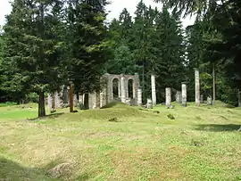
Ornes is a commune in the Meuse department in Grand Est in north-eastern France. The village is one of the nine French villages destroyed in the First World War and one of six that was never rebuilt. It's now a memorial place.
Ornes | |
|---|---|
 Ruins of the Ornes church | |
 Coat of arms | |
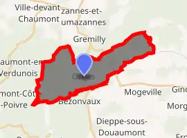
Location of Ornes 
| |
 Ornes  Ornes | |
| Coordinates: 49°15′13″N 5°28′21″E | |
| Country | France |
| Region | Grand Est |
| Department | Meuse |
| Arrondissement | Verdun |
| Canton | Belleville-sur-Meuse |
| Intercommunality | Grand Verdun |
| Government | |
| • Mayor (2014-2020) | Charles Saint-Vanne |
| Area 1 | 18.52 km2 (7.15 sq mi) |
| Population (2017-01-01)[1] | 5 |
| • Density | 0.27/km2 (0.70/sq mi) |
| Time zone | UTC+01:00 (CET) |
| • Summer (DST) | UTC+02:00 (CEST) |
| INSEE/Postal code | 55394 /55150 |
| Elevation | 209–327 m (686–1,073 ft) (avg. 250 m or 820 ft) |
| 1 French Land Register data, which excludes lakes, ponds, glaciers > 1 km2 (0.386 sq mi or 247 acres) and river estuaries. | |
Even though a few houses and a handful of permanent residents remain, the village is classified as having "died for France".
Location
Ornes is located on the departmental road 24, at the foot of the coast which borders the course of the Meuse to the east, a dozen kilometers as the crow flies north-east of Verdun. The Orne, a stream which, having become a river, flows into the Moselle at Richemont near Hagondange, has its source in the territory of the municipality.
The village is now located on the edge of the Verdun national forest which covers the coasts and camouflages the thousands of shell holes that fell during the First World War and still perfectly visible today.
History
It was called Ornes in 1793, Ornes in 1801 .In Lorraine, the town is called Ioûne.
The village already existed in 1046 and depended on the Saint-Maur de Verdun abbey. Freed in 1251, it became the capital of an important barony, a bailiwick and a provost.
In 1285, Aubert or Albert d'Ornes was one of the guests of the Comte de Chiny in Chauvency-le-Château: he fought during the famous tournament (related by Jacques Bretel) alongside the Briey, Rosières, Cumières and Creuë.
In 1653, the Lorraine troops, Catholics, invested the castle of Ornes whose lords had followed the movement of the Reformation.
On February 21, 1916, the thunder of cannons marked the start of the Battle of Verdun. Located in the sector of Verdun, the village, taken by German troops on February 24, 1916, will be retaken by the French on August 23, 1917. In the meantime it will have been totally ruined by the fierce exchange of artillery.
Before its destruction, Ornes was an important village since its population exceeded 1,300 inhabitants by the middle of the 19th century. Several mills and weaving workshops were part of it. On the eve of 1914 there were still more than 700 inhabitants, living from agriculture and crafts. Ornes served as a village.
On the last years of the life of Ornes, one can consult the very documented work of Canon Charles Laurent, former director of the major seminary of Verdun: "Ornes, the life and death of a Meusien village", published in the Memoirs of the Society of Letters, Sciences and Arts of Bar-le-Duc (Volume 49).
Population
In 2018, the commune had 6 inhabitants.[2]
| Year | Pop. | ±% |
|---|---|---|
| 2005 | 2 | — |
| 2006 | 2 | +0.0% |
| 2007 | 2 | +0.0% |
| 2008 | 3 | +50.0% |
| 2009 | 5 | +66.7% |
| 2010 | 6 | +20.0% |
| 2011 | 6 | +0.0% |
| 2012 | 6 | +0.0% |
| 2013 | 6 | +0.0% |
| 2014 | 5 | −16.7% |
| 2015 | 5 | +0.0% |
| 2016 | 6 | +20.0% |
Politics
Presidential Elections Second Round:[3]
| Election | Winning Candidate | Party | % | |
|---|---|---|---|---|
| 2017 | Marine Le Pen | FN | 100.00 | |
| 2012 | Nicolas Sarkozy | UMP | 85.71 | |
| 2007 | Nicolas Sarkozy | UMP | 71.43 | |
| 2002 | Jacques Chirac | RPR | 100.00 | |
Geography
Ornes is located on departmental road 24, about 12 km to the north-east of Verdun. The source of the Orne river is in the commune.
The village is on the border of the Verdun forest where thousands of shells fell during World War I.