Le Pouget
Le Pouget is a commune in the Hérault department in the Occitanie region in southern France. It contains the Gallardet dolmen.
Le Pouget | |
|---|---|
 The church of Sainte-Catherine | |
.svg.png.webp) Coat of arms | |
Location of Le Pouget 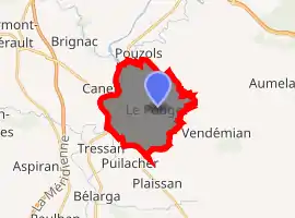
| |
 Le Pouget  Le Pouget | |
| Coordinates: 43°35′36″N 3°31′32″E | |
| Country | France |
| Region | Occitanie |
| Department | Hérault |
| Arrondissement | Lodève |
| Canton | Gignac |
| Intercommunality | Vallée de l'Hérault |
| Government | |
| • Mayor (2008–2014) | Louis Villaret |
| Area 1 | 13.91 km2 (5.37 sq mi) |
| Population (2017-01-01)[1] | 2,054 |
| • Density | 150/km2 (380/sq mi) |
| Time zone | UTC+01:00 (CET) |
| • Summer (DST) | UTC+02:00 (CEST) |
| INSEE/Postal code | 34210 /34230 |
| Elevation | 25–161 m (82–528 ft) (avg. 95 m or 312 ft) |
| 1 French Land Register data, which excludes lakes, ponds, glaciers > 1 km2 (0.386 sq mi or 247 acres) and river estuaries. | |
Geography
Le Pouget is situated on the sides of two valleys, Aumelas and Clermont L'Hérault. The centre of the commune is at the entrance to the medieval circulade. The clay soil favours viticulture. The Hérault river is 2 km from the centre.
History
The village was known for its circulade in the Middle Ages in the time of Louis XIV. The prehistoric dolmen Gallardet (or dolmen de Pouget) is a notable sight in the village.
Population
| Year | Pop. | ±% |
|---|---|---|
| 1962 | 1,035 | — |
| 1968 | 1,077 | +4.1% |
| 1975 | 934 | −13.3% |
| 1982 | 987 | +5.7% |
| 1990 | 1,103 | +11.8% |
| 1999 | 1,347 | +22.1% |
| 2008 | 1,794 | +33.2% |
Inhabitants are Pougétois.
Sights
- Église Saint-Jacques, Romanesque church (now the Chapelle des pénitents blancs)
- Église Sainte-Catherine, Gothic church (now the parish church)
- Dolmen
- Saint-Amant fountain
- The circulade
- Château de l'Estang (private property).
 Entrance to dolmen
Personalities
- d'Alzon family
- Jacqueline Mirande, French novelist
- Jean-Paul Nozière, French novelist
See also
References
- "Populations légales 2017". INSEE. Retrieved 6 January 2020.
External links
| Wikimedia Commons has media related to Le Pouget. |
| Authority control |
|
|---|
This article is issued from Wikipedia. The text is licensed under Creative Commons - Attribution - Sharealike. Additional terms may apply for the media files.
