Saint-Étienne-de-Gourgas
Saint-Étienne-de-Gourgas is a commune in the Hérault department in the Occitanie region in southern France.
Saint-Étienne-de-Gourgas | |
|---|---|
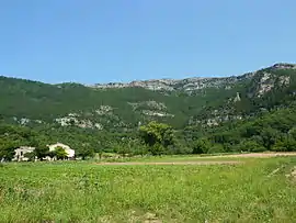 Cirque du Bout du Monde | |
Location of Saint-Étienne-de-Gourgas 
| |
 Saint-Étienne-de-Gourgas  Saint-Étienne-de-Gourgas | |
| Coordinates: 43°46′14″N 3°22′42″E | |
| Country | France |
| Region | Occitanie |
| Department | Hérault |
| Arrondissement | Lodève |
| Canton | Lodève |
| Intercommunality | Lodévois-Larzac |
| Government | |
| • Mayor (2008–2014) | Lionel Micola |
| Area 1 | 19.43 km2 (7.50 sq mi) |
| Population (2017-01-01)[1] | 494 |
| • Density | 25/km2 (66/sq mi) |
| Time zone | UTC+01:00 (CET) |
| • Summer (DST) | UTC+02:00 (CEST) |
| INSEE/Postal code | 34251 /34700 |
| Elevation | 240–762 m (787–2,500 ft) (avg. 380 m or 1,250 ft) |
| 1 French Land Register data, which excludes lakes, ponds, glaciers > 1 km2 (0.386 sq mi or 247 acres) and river estuaries. | |
Geography
Saint-Étienne-de-Gourgas is known for the "Cirque du Bout du Monde" which was formed from a meander in the Ruisseau de la Bronzinadouïre that cut deeply into the plateau of the Causse du Larzac leaving the monumental chalk cliffs.
Population
| Year | Pop. | ±% |
|---|---|---|
| 1962 | 221 | — |
| 1968 | 233 | +5.4% |
| 1975 | 212 | −9.0% |
| 1982 | 254 | +19.8% |
| 1990 | 253 | −0.4% |
| 1999 | 308 | +21.7% |
| 2008 | 449 | +45.8% |
See also
References
- "Populations légales 2017". INSEE. Retrieved 6 January 2020.
| Wikimedia Commons has media related to Saint-Étienne-de-Gourgas. |
| Authority control |
|---|
This article is issued from Wikipedia. The text is licensed under Creative Commons - Attribution - Sharealike. Additional terms may apply for the media files.