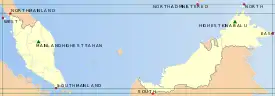
List of extreme points of Malaysia
The extreme points of Malaysia include the coordinates that are further north, south, east or west than any other location in Malaysia; and the highest and the lowest altitudes in the country.
The latitude and longitude are expressed in decimal degree notation, in which a positive latitude value refers to the northern hemisphere, and a negative value refers to the southern hemisphere. Similarly, a positive longitude value refers to the eastern hemisphere, and a negative value refers to the western hemisphere. The coordinates used in this article are sourced from Google Earth, which makes use of the WGS84 geodetic reference system. Additionally, a negative altitude value refers to land below sea level.
Extreme points
Overall
| Heading | Location | State | Bordering entity | Coordinates† | Ref |
|---|---|---|---|---|---|
| North (disputed) |
Swallow Reef in the Spratly Islands off the coast of Kota Kinabalu
|
Sabah | South China Sea | 7°22′20″N 113°50′30″E
|
|
| North (undisputed) |
Pulau Guhuan Utara near Banggi Island | Sabah | Sulu Sea | 7°22′46″N 117°14′05″E | |
| South | Bukit Niat near Serian | Sarawak | Kalimantan, Indonesia | 0°51′10″N 110°34′17″E | |
| East | Near Kampong Look Sembuang in Lahad Datu | Sabah | Sulu Sea | 5°14′27″N 119°16′00″E | |
| West | Pulau Perak | Kedah | Strait of Malacca | 6°5′26″N 98°55′48″E |
Peninsular Malaysia
The following are the extreme physical land mass points on the Malaysian peninsula inclusive of islands.
| Heading | Location | State | Bordering entity | Coordinates† | Ref |
|---|---|---|---|---|---|
| North | Bukit China near Wang Kelian | Perlis | Thailand | 6°43′33″N 100°12′14″E | |
| South | Tanjung Piai | Johor | Strait of Malacca | 1°15′58″N 103°30′39″E | |
| East | Pulau Aur | Johor | South China Sea | 2°26′57″N 104°31′30″E | |
| West | Pulau Perak | Kedah | Strait of Malacca | 6°5′26″N 98°55′48″E |
East Malaysia
The following are the extreme physical land mass points in East Malaysia inclusive of islands.
| Heading | Location | State | Bordering entity | Coordinates† | Ref |
|---|---|---|---|---|---|
| North (disputed) |
Swallow Reef | Sabah | South China Sea | 7°22′20″N 113°50′30″E | |
| North (undisputed) |
Pulau Guhuan Utara near Banggi Island | Sabah | Sulu Sea | 7°22′46″N 117°14′05″E | |
| South | Bukit Niat near Serian | Sarawak | Kalimantan, Indonesia | 0°51′10″N 110°34′17″E | |
| East | Near Kampong Look Sembuang in Lahad Datu | Sabah | Sulu Sea | 5°14′27″N 119°16′00″E | |
| West | Near Gunung Cermai in Kuching | Sarawak | Kalimantan, Indonesia | 1°54′15″N 109°32′48″E |
Extreme altitudes
| Extremity | Name | Altitude | State | Coordinates† | Ref |
|---|---|---|---|---|---|
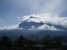
| Highest (Borneo) | Mount Kinabalu | 4,095 m (13,435 ft) | Sabah | 06°04′23″N 116°33′40″E | [1] |
| Highest (Peninsular) | Mount Tahan | 2,187 m (7,175 ft) | Pahang | 4°37′56″N 102°14′03″E | [2] |
| Lowest | South China Sea | 0 m (0 ft) | 2°7′23″N 106°33′16″E | [3] |
Notes
- ^† Coordinates obtained from Google Earth. Google Earth makes use of the WGS84 geodetic reference system.
References
- Phillipps, A. & F. Liew 2000. Globetrotter Visitor's Guide – Kinabalu Park. New Holland Publishers (UK) Ltd.
- "Google Maps (Gunung Tahan)". Google. Retrieved 1 August 2009.
- "Malaysia - Land Statistics". WorldAtlas.com. Retrieved 31 July 2009.
See also

| Sovereign states |
|
|---|---|
| States with limited recognition |
|
| Dependencies and other territories |
|
| |