Lock and Dam No. 16
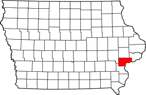
Lock and Dam No. 16 is a lock and dam located near Muscatine, Iowa on the Upper Mississippi River around river mile 457.2. The movable portion of the dam is 1,315 feet (400.8 m) long and consists of 4 roller gates and 15 Tainter gates. The lock is 110 feet (33.5 m) wide by 600 feet (182.9 m) long with a maximum lift of 9 feet (2.7m)[2] In 2004, the facility was listed in the National Register of Historic Places as Lock and Dam No. 16 Historic District, #04000176 covering 1,024 acres (4.1 km2), 1 building, 5 structures, and 2 objects.
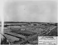 Public Works Administration Project and Army Corps of Engineers Lock and Dam #16 construction. |
 |
 Mississippi River Lock and Dam number 16 | |
| Location | Sweetland Township, Muscatine County, Iowa / Drury Township, Rock Island County, Illinois, near Muscatine, Iowa, USA |
|---|---|
| Coordinates | 41°25′37.29″N 91°0′37.75″W |
| Construction began | 1933 |
| Opening date | July 10, 1937 |
| Operator(s) | |
| Dam and spillways | |
| Impounds | Upper Mississippi River |
| Length | 1,315 feet (400.8 m) |
| Reservoir | |
| Creates | Pool 16 |
| Total capacity | 88,400 acre⋅ft (0.1090 km3) |
| Catchment area | 99,400 sq mi (257,000 km2) |
Lock and Dam No. 16 Historic District | |
  | |
| Location | 33109 102nd Ave. W, Muscatine, Iowa |
| Area | 102.4 acres (41.4 ha) |
| Built | 1937 |
| Architect | U.S. Army Corps of Engineers |
| MPS | Upper Mississippi River 9-Foot Navigation Project MPS |
| NRHP reference No. | 04000176[1] |
| Added to NRHP | March 10, 2004 |
References
- "National Register Information System". National Register of Historic Places. National Park Service. July 9, 2010.
- "Lock & Dam 16" (PDF). U.S. Army Corps of Engineers. Retrieved January 6, 2014.
External links
| Wikimedia Commons has media related to Mississippi River Lock and Dam number 16. |
- Lock and Dam No. 16 - U.S. Army Corps of Engineers
- HAER - Mississippi River 9-Foot Channel Project, Lock & Dam No. 16, Upper Mississippi River, Muscatine vicinity, Muscatine County, IA
| List of locks and dams of the Upper Mississippi River | ||
|---|---|---|
| Upstream: Lock and Dam No. 15 |
Downstream: Lock and Dam No. 17 | |
| Topics | |
|---|---|
| Lists by state |
|
| Lists by insular areas | |
| Lists by associated state | |
| Other areas | |
| Related | |
| |
This article is issued from Wikipedia. The text is licensed under Creative Commons - Attribution - Sharealike. Additional terms may apply for the media files.