Metro (Minnesota)
Metro (styled as METRO) is a high-capacity transport network serving the Minneapolis-Saint Paul metropolitan area. As of 2020, the system consists of two light rail lines (Blue and Green Lines) and three bus rapid transit lines (Red Line, A and C Lines) operated by Metro Transit. The five lines connect Downtown Minneapolis and St Paul with Bloomington, Minneapolis-St Paul International Airport, Roseville, and Brooklyn Center, with several new lines and extensions in the planning stages.
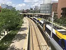 An westbound Green Line train approaching the Washington Avenue Bridge traveling past the Weisman Art Museum on the University of Minnesota's East Bank | |||
| Overview | |||
|---|---|---|---|
| Owner | Metropolitan Council | ||
| Locale | Minneapolis-St. Paul metropolitan area | ||
| Transit type | Light rail (LRT) Bus rapid transit (BRT) | ||
| Number of lines | 2 LRT lines 3 BRT lines | ||
| Line number | Blue Line Green Line Red Line A Line C Line | ||
| Number of stations | 82 | ||
| Website | METRO | ||
| Operation | |||
| Began operation | 26 June 2004 | ||
| Operator(s) | Metro Transit | ||
| |||
Prior to August 17, 2019, service along the entire length of the Green Line operated 24/7, the only one of 22 light rail systems in the United States to do so, but a common practice on some heavy rail lines such as the New York City Subway and PATH. The service gap from 2 a.m. to 4 a.m. was replaced by bus service.[1][2][3][4] Metro Transit also provides 24/7 service between the stations serving the Lindbergh and Humphrey terminals of MSP Airport; the remainder of the Blue Line operates from 3:29 a.m. to 1:54 a.m. Monday through Thursday, and 24 hours a day from 3:29 a.m. on Friday morning to 1:54 a.m. on Sunday morning.[5][6]
In the 1970s, roughly contemporaneous with the construction of Washington D.C.'s Metro system and San Francisco's Bay Area Rapid Transit, the newly formed Metropolitan Council contemplated the creation of a similar mass transit for the Minneapolis-St. Paul metro area, but the idea was eventually abandoned due to opposition from the Minnesota Legislature.[7] For the next few decades, there were repeated proposals to build light rail along several corridors, particularly the University Avenue corridor between downtown Minneapolis and Saint Paul (the present Green Line), but the idea of light rail only gained steam in the late 1990s.
In 1999, the Minnesota Legislature approved funding for the first line (the present Blue Line) along Hiawatha Avenue (initially named the Hiawatha Line[8]) in south Minneapolis, which opened in 2004. In 2011, in anticipation of the opening of the Red Line and Green Line, and in order to help passengers better identify with each of the routes, Metro Transit announced that the system would be rebranded and each line assigned a unique color. The first phase of the Red Line opened in mid-2013, and the first phase of the Green Line (also known as the Central Corridor) in mid-2014. Extensions are planned to bring the system into the western metro area, with construction anticipated near the end of the decade.
Current system
Minneapolis-Saint Paul METRO System | |||||||||||||||||||||||||||||||||||||||||||||||||||||||||||||||||||||||||||||||||||||||||||||||||||||||||||||||||||||||||||||||||||||||||||||||||||||||||||||||||||||||||||||||||||||||||||||||||||||||||||||||||||||||||||||||||||||||||||||||||||||||||||||||||||||||||||||||||||||||||||||||||||||||||||||||||||||||||||||||||||||||||||||||||||||||||||||||||||||||||||||||||||||||||||||||||||||||||||||||||||||||||||||||||||||||||||||||||||||||||||||||||||||||||||||||||||||||||||||||||||||||||||||||||||||||||||||||||||||||||||||||||||||||||||||||||||||||||||||||||||||||||||||||||||||
|---|---|---|---|---|---|---|---|---|---|---|---|---|---|---|---|---|---|---|---|---|---|---|---|---|---|---|---|---|---|---|---|---|---|---|---|---|---|---|---|---|---|---|---|---|---|---|---|---|---|---|---|---|---|---|---|---|---|---|---|---|---|---|---|---|---|---|---|---|---|---|---|---|---|---|---|---|---|---|---|---|---|---|---|---|---|---|---|---|---|---|---|---|---|---|---|---|---|---|---|---|---|---|---|---|---|---|---|---|---|---|---|---|---|---|---|---|---|---|---|---|---|---|---|---|---|---|---|---|---|---|---|---|---|---|---|---|---|---|---|---|---|---|---|---|---|---|---|---|---|---|---|---|---|---|---|---|---|---|---|---|---|---|---|---|---|---|---|---|---|---|---|---|---|---|---|---|---|---|---|---|---|---|---|---|---|---|---|---|---|---|---|---|---|---|---|---|---|---|---|---|---|---|---|---|---|---|---|---|---|---|---|---|---|---|---|---|---|---|---|---|---|---|---|---|---|---|---|---|---|---|---|---|---|---|---|---|---|---|---|---|---|---|---|---|---|---|---|---|---|---|---|---|---|---|---|---|---|---|---|---|---|---|---|---|---|---|---|---|---|---|---|---|---|---|---|---|---|---|---|---|---|---|---|---|---|---|---|---|---|---|---|---|---|---|---|---|---|---|---|---|---|---|---|---|---|---|---|---|---|---|---|---|---|---|---|---|---|---|---|---|---|---|---|---|---|---|---|---|---|---|---|---|---|---|---|---|---|---|---|---|---|---|---|---|---|---|---|---|---|---|---|---|---|---|---|---|---|---|---|---|---|---|---|---|---|---|---|---|---|---|---|---|---|---|---|---|---|---|---|---|---|---|---|---|---|---|---|---|---|---|---|---|---|---|---|---|---|---|---|---|---|---|---|---|---|---|---|---|---|---|---|---|---|---|---|---|---|---|---|---|---|---|---|---|---|---|---|---|---|---|---|---|---|---|---|---|---|---|---|---|---|---|---|---|---|---|---|---|---|---|---|---|---|---|---|---|---|---|---|---|---|---|---|---|---|---|---|---|---|---|---|---|---|---|---|---|---|---|---|---|---|---|---|---|---|---|---|---|---|---|---|---|---|---|---|---|---|---|---|---|---|---|---|---|---|---|---|---|---|---|---|---|---|---|---|---|---|---|---|---|---|---|---|---|---|---|---|---|---|---|---|---|---|---|---|---|---|---|---|---|---|---|---|---|---|---|---|---|---|---|---|---|---|---|---|---|---|---|---|---|---|---|---|---|---|---|---|---|---|---|---|---|---|---|---|---|---|---|---|---|---|
System diagram | |||||||||||||||||||||||||||||||||||||||||||||||||||||||||||||||||||||||||||||||||||||||||||||||||||||||||||||||||||||||||||||||||||||||||||||||||||||||||||||||||||||||||||||||||||||||||||||||||||||||||||||||||||||||||||||||||||||||||||||||||||||||||||||||||||||||||||||||||||||||||||||||||||||||||||||||||||||||||||||||||||||||||||||||||||||||||||||||||||||||||||||||||||||||||||||||||||||||||||||||||||||||||||||||||||||||||||||||||||||||||||||||||||||||||||||||||||||||||||||||||||||||||||||||||||||||||||||||||||||||||||||||||||||||||||||||||||||||||||||||||||||||||||||||||||||
| |||||||||||||||||||||||||||||||||||||||||||||||||||||||||||||||||||||||||||||||||||||||||||||||||||||||||||||||||||||||||||||||||||||||||||||||||||||||||||||||||||||||||||||||||||||||||||||||||||||||||||||||||||||||||||||||||||||||||||||||||||||||||||||||||||||||||||||||||||||||||||||||||||||||||||||||||||||||||||||||||||||||||||||||||||||||||||||||||||||||||||||||||||||||||||||||||||||||||||||||||||||||||||||||||||||||||||||||||||||||||||||||||||||||||||||||||||||||||||||||||||||||||||||||||||||||||||||||||||||||||||||||||||||||||||||||||||||||||||||||||||||||||||||||||||||
| |||||||||||||||||||||||||||||||||||||||||||||||||||||||||||||||||||||||||||||||||||||||||||||||||||||||||||||||||||||||||||||||||||||||||||||||||||||||||||||||||||||||||||||||||||||||||||||||||||||||||||||||||||||||||||||||||||||||||||||||||||||||||||||||||||||||||||||||||||||||||||||||||||||||||||||||||||||||||||||||||||||||||||||||||||||||||||||||||||||||||||||||||||||||||||||||||||||||||||||||||||||||||||||||||||||||||||||||||||||||||||||||||||||||||||||||||||||||||||||||||||||||||||||||||||||||||||||||||||||||||||||||||||||||||||||||||||||||||||||||||||||||||||||||||||||
| |||||||||||||||||||||||||||||||||||||||||||||||||||||||||||||||||||||||||||||||||||||||||||||||||||||||||||||||||||||||||||||||||||||||||||||||||||||||||||||||||||||||||||||||||||||||||||||||||||||||||||||||||||||||||||||||||||||||||||||||||||||||||||||||||||||||||||||||||||||||||||||||||||||||||||||||||||||||||||||||||||||||||||||||||||||||||||||||||||||||||||||||||||||||||||||||||||||||||||||||||||||||||||||||||||||||||||||||||||||||||||||||||||||||||||||||||||||||||||||||||||||||||||||||||||||||||||||||||||||||||||||||||||||||||||||||||||||||||||||||||||||||||||||||||||||
Lines
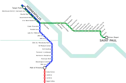
- Blue Line: Target Field Station - Minneapolis-St. Paul International Airport - Mall of America
- Green Line: Target Field Station - University of Minnesota - Union Depot
- Red Line: Mall of America - Apple Valley Transit Station
- A Line: 46th Street station - Rosedale Center
- C Line: Downtown Minneapolis - Brooklyn Center Transit Center
The current Metro system consists of five separate projects. There are two light rail lines: the Blue Line, which runs from Target Field in downtown Minneapolis past Minneapolis-St Paul International Airport to the Mall of America, and the Green Line, which runs from Target Field past the University of Minnesota to the Union Depot in downtown Saint Paul. The BRT Red Line serves as an extension of the Blue Line across the Minnesota River, where it connects with southern suburbs at four different stations. Low ridership projections would have made the required bridge for an extension of the Blue Line economically infeasible. The arterial BRT A and C lines serve as upgrades to existing local bus routes and connect with the Blue and Green lines at certain shared stations.
Together, the two light rail lines run on 21.8 miles (35.1 km) of route.[9][10] There are a total of 82 stations; five shared between the Green and Blue Lines in downtown Minneapolis, one shared at the Mall of America between the Blue and the Red Lines, one shared at 46th Street station between the Blue and the A Lines, one shared at Snelling Avenue station between the Green and the A Lines, 13 exclusively for the Blue Line, 16 for the Green Line, four for the Red Line, 18 for the A Line, and 23 for the C Line. The main hub of the system is Target Field Station in Minneapolis, though Saint Paul Union Depot is envisioned as an additional future hub.
Trains and buses run approximately every 10 minutes throughout the day, with reduced schedules at night and on weekends. All stations have electronic displays that show predicted real-time departure information, known as NexTrip. Predicted real-time departure information is also available through Metro Transit's website.
Fares
Metro uses a proof-of-payment system, requiring riders to carry tickets at all times. Fares are purchased before boarding, either at ticket machines located in the stations or by scanning a Go-To card at dedicated pedestals. Tickets are valid for 2 1/2 hours after purchase, with transfers available to other Metro lines as well as any Metro Transit bus routes. Within the two Downtown Zones of Minneapolis and St. Paul, tickets are 50¢; otherwise they follow normal Metro Transit fares:
- Adults: $2.50 rush hours, $2 otherwise
- Seniors, Youth, Medicare Card Holders: $2.50 rush, $1 otherwise
- Persons with Disability: $1
- Children under 6: free with paying rider. Limit is 3.
In addition, passes are available for various lengths of time or numbers of trips at appropriate discounts. In addition, students at the University of Minnesota have the option of purchasing U-Passes, which give unlimited rides throughout the semester.
Passengers at Minneapolis-St Paul International Airport can move between the Terminal 1-Lindbergh station and Terminal 2–Humphrey station free of charge.
Future
Several expansion projects are planned for the Metro system, at various stages of completion. These include both light rail extensions and connecting bus rapid transit services.
B Line
The B line is an arterial bus rapid transit route proposed for the Twin Cities' Lake Street/Marshall Avenue corridor, running from Bde Maka Ska in Minneapolis' Uptown neighborhood to the Snelling & Dayton station of the A Line,[11] with an extension to downtown Saint Paul along Selby Avenue.[12][13] Planning is underway and will continue through early 2020. Station design is planned for 2020–2021 with beginning of construction anticipated in 2022, pending full funding.
D Line
The D Line is an arterial bus rapid transit route currently in engineering stages. The route will travel from Brooklyn Center through Downtown Minneapolis and onward through south Minneapolis to the Mall of America. The Route will travel mostly on Fremont and Emerson Avenues in North Minneapolis and Chicago Avenue in South Minneapolis.[14] The project is shovel ready and is awaiting an additional $20 million to begin construction.[15]
E Line
The E line is an arterial bus rapid transit route proposed for the Twin Cities's Hennepin Avenue corridor.[16] Metro Transit's 2012 rapid bus study identified a route that would run from downtown Minneapolis to a future Lake Street station on the METRO Green Line extension. However, after further study in the spring of 2019, Metro Transit recommended a route from the Green Line's Stadium Village stop, through Dinkytown to Hennepin Avenue, and then south via Hennepin, 44th Street, and France Avenue to the Southdale Transit Center.[17] Pending full project funding, E Line construction could begin as soon as 2023.
Green Line extension
The Green Line extension (also known as the Southwest LRT) is a planned expansion of the Green Line, to run from Target Field Station to several southwestern suburbs. The project was given federal approval in November 2018, and ground was broken on construction on November 30, 2018[18] Completion of the project is expected in 2023, at an expected cost of approximately US$2 billion. It will be the largest infrastructure project in state history.[19]
Blue Line extension
The Blue Line extension (known as Bottineau LRT) is a planned extension of the Blue Line to Brooklyn Park. The project is under development with a planned 2024 implementation.[20]
Orange Line
The Orange Line is a planned bus rapid transit route to run along I-35W from Minneapolis south into Richfield, Bloomington and Burnsville, with plans to later extend into Lakeville. The Orange Line will parallel the Red Line approximately 3 miles to the east. It is expected to be in operation in 2021.[21] .
Gold Line
The Gold Line is a planned bus rapid transit route to run along Interstate 94 from Woodbury to Mounds Boulevard in Saint Paul, then through downtown to Union Station, terminating near United Hospital.[22] The project is under development with a planned 2024 implementation.[23]
Rush Line
The Rush Line is a planned bus rapid transit route to run largely along the Ramsey County Regional Railroad Authority corridor adjacent to the Bruce Vento Regional Trail from downtown Saint Paul to downtown White Bear Lake, Minnesota.[24] The project is under development with a planned 2026 implementation.
Riverview
The Riverview Corridor is a transit corridor connecting Downtown Saint Paul and the Mall of America in Bloomington via the Minneapolis-Saint Paul International Airport. The corridor serves an area from the Saint Paul Union Depot to the Mall via parts of the METRO Green Line and the METRO Blue Line, and a route running parallel to West 7th Street, which runs southwest from Downtown Saint Paul. The corridor creates a triangle connecting opposite ends of the Blue Line and Green Line. In December of 2017, a modern streetcar system similar to systems in Portland, Kansas City, and Detroit was selected as the locally preferred alternative with an alignment along West Seventh Street and MN-5.[25]
Other
In early 2021, three corridors will be chosen for bus rapid transit implementation. Out of the eleven corridors studied, the three lines selected will be built as the METRO F Line, G Line, and H Line, with the same characteristics as the METRO A Line and C Line. All three lines are expected to begin construction at the same time in 2024-2025.[26][27]
There are also numerous proposals in early planning stages for routes along Interstate 394 from Minneapolis to Wayzata, Highway 169 from Minneapolis to Shakopee, Interstate 35 from Minneapolis and St. Paul to Forest Lake, Highway 36 from St. Paul to Stillwater and Highway 61 from St. Paul to Hastings (Red Rock Corridor).
Operations
The Metro system's rail lines use a combination of exclusive and shared right-of-way, depending on the circumstances. Within the two Downtown Zones, trains run on surface streets in an exclusive right-of-way, without preemption. The Blue Line runs primarily alongside Hiawatha Avenue (Minnesota State Highway 55), along land originally acquired for expansion of that highway, except for a brief stretch in a tunnel underneath Minneapolis-St Paul International Airport. The Green Line runs along the median of University Avenue in an exclusive right-of-way, except for a brief stretch of the Washington Avenue Transit Mall where its tracks are shared with buses. The Blue Line's at-grade crossings are protected by automated grade crossing gates; the Green Line's crossings move in regular traffic, with signal priority but no preemption.
Since the completion of three-car station extensions in winter 2010, Metro Transit operates one-, two- and three-car trains on the Blue Line, depending on the time of day and ridership needs. Many stations on the line were initially built to be capable of serving only one- or two-car trains, as a cost-saving measure; all of the shorter platforms were designed and built with future extension in mind and currently all stations are capable of serving three-car trains. The Green Line was built with three-car platforms at all stations.
Rolling stock
Currently two models of LRVs run in the Metro system.
Type I
Type I LRVs are Bombardier Flexity Swifts, utilizing a low floor for accessible boarding at all stations. Metro Transit operates 27 vehicles on the lines, numbered 101 through 127. Initially painted with Metro Transit livery, all have been repainted as of 2015 to reflect the Metro system branding. During this time, Type I cars also were retrofitted with colored LCD headboards for route destination displays and other improvements.
Type II
Type II LRVs are Siemens S70/Avantos. 59 vehicles have been ordered, primarily to serve the Green Line. Type II LRVs are mechanically, but not electronically, compatible with the current fleet of 27 "type I" vehicles, so while the two generations do run on the tracks at the same time and both types are able to push a malfunctioning unit of the other type, multiple-unit consists may only be assembled of one type.[28]
See also
References
- Combs, Marianne (17 May 2019). "Green Line pulls back some overnight service". MPR News. Retrieved 24 September 2020.
- "Routes will change Aug. 17". www.metrotransit.org. 2020. Archived from the original on 1 August 2019. Retrieved 24 September 2020.
- Moore, Janet (19 August 2019). "'Transit is not a shelter': Green Line curtails all-night service". Star Tribune. Retrieved 24 September 2020.
- "Online Schedules - METRO Green Line". Metro Transit. Retrieved 2014-06-23.
- "Metro Transit - Online Schedules - METRO Green Line". www.metrotransit.org.
- "Metro Transit - Online Schedules - METRO Blue Line". www.metrotransit.org.
- "Special Review Hiawatha Avenue Light Rail Transit Line". OFFICE OF THE LEGISLATIVE AUDITOR STATE OF MINNESOTA. March 1, 2002. Archived from the original on July 14, 2014. Retrieved 2014-06-23.
- "News Updates & Events - Metro Transit". www.metrotransit.org.
- "METRO Blue Line - Facts About Trains and Construction". Metro Transit. 2013. Archived from the original on 2014-02-14. Retrieved 2014-06-15.
- "Metro Green Line Fact Sheet". Metropolitan Council. 2014. Archived from the original on 2014-06-12. Retrieved 2014-06-15.
- "METRO B Line (Lake Street / Marshall Avenue)". Retrieved May 24, 2019.
- "St. Paul chamber, mayor call for new B Line bus to extend to downtown St. Paul". Retrieved May 24, 2019.
- Roth, Katie; Smith, Adam (28 October 2019). "METRO B Line Update and Preliminary Recommendations". Retrieved 20 November 2019.
- "D Line (Chicago-Fremont rapid bus)". Retrieved May 24, 2019.
- "D Line FAQs". www.metrotransit.org. Retrieved 20 November 2019.
- "E Line (Hennepin Avenue rapid bus project)". Retrieved May 24, 2019.
- "METRO E Line Corridor Study". Retrieved November 1, 2019.
- "Federal, state and local officials break ground on Southwest LRT". Retrieved May 24, 2019.
- "SWLRT GETS CRITICAL APPROVAL FROM FEDERAL GOVERNMENT TO BEGIN CONSTRUCTION". Metropolitan Council. November 14, 2018. Retrieved November 19, 2018.
- "Welcome to the expanding METRO network". Metro Transit. Retrieved 14 June 2019.
- "Welcome to the expanding METRO network". Metro Transit. Retrieved 14 June 2019.
- "General Project Fact Sheet" (PDF).
- "Welcome to the expanding METRO network". Metro Transit. Retrieved 14 June 2019.
- https://www.ramseycounty.us/residents/roads-transit/transit-corridors-studies/rush-line-brt-project
- Melo, Fredrick (December 14, 2017). "Panel approves St. Paul-to-airport streetcar concept, but much more work to come". Pioneer Press. Retrieved December 18, 2017.
- "Arterial Bus Rapid Transit (BRT) Planning - Metro Transit". www.metrotransit.org. Retrieved 24 September 2020.
- "Network Next Project FAQs". www.metrotransit.org. Retrieved 24 September 2020.
- "Transportation Committee Meeting July 26, 2010". Metropolitan Council. July 26, 2010. Retrieved 2010-08-06.
External links
![]() Media related to Metro Transit (Minneapolis-Saint Paul) at Wikimedia Commons
Media related to Metro Transit (Minneapolis-Saint Paul) at Wikimedia Commons
