Tahamí Terrane
The Tahamí (Spanish: Terreno Tahamí, TT) or Tahamí-Panzenú Terrane is one of the geological provinces (terranes) of Colombia. The terrane, dating to the Permo-Triassic, is situated on the North Andes Plate. The contact with the Chibcha, Arquía and Quebradagrande Terranes is formed by the megaregional Romeral Fault System.[1] A tiny terrane is located at the contact with the Quebradagrande Terrane; Anacona Terrane.[2]
| Tahamí Terrane Stratigraphic range: Permo-Triassic (emplaced) ~280–230 Ma | |
|---|---|
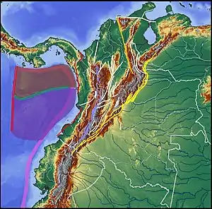 Tahamí Terrane is enclosed by the Bucaramanga-Santa Marta Fault (orange), northernmost Oca Fault (white) and Romeral Fault System (violet) | |
| Type | Terrane |
| Unit of | North Andes Plate |
| Sub-units | Subunits |
| Underlies | Arquía, Caribbean, La Guajira & Quebradagrande Terranes |
| Overlies | Chibcha Terrane |
| Lithology | |
| Primary | Complexes, basins |
| Other | Volcanoes |
| Location | |
| Coordinates | 7°08′00″N 75°13′45″W |
| Region | Andean, Caribbean |
| Country | |
| Extent | Central, Macuira, SNSM |
| Type section | |
| Named for | Tahamí, Nutabe |
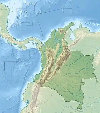 Tahamí Terrane (Colombia) 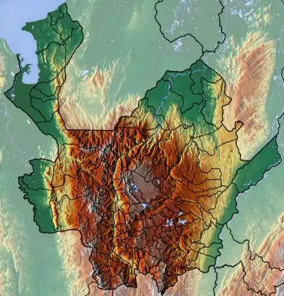 Tahamí Terrane (Antioquia Department) | |
The terrane is offset along the regional Bucaramanga-Santa Marta Fault from the Caribbean, La Guajira and Chibcha Terranes,[3] and by the regional Oca Fault with the Chibcha Terrane.[4]
Etymology
_-_Carta_XVII_-_Geolog%C3%ADa_de_Colombia%252C_Venezuela_y_Ecuador.jpg.webp)
(Codazzi, 1890)
The terrane is, as the Chibcha Terrane, named after an indigenous people from Antioquia; the Chibcha-speaking Tahamí, part of the greater Nutabe group. Panzenú refers to the Zenú civilization, that thrived from about 200 BCE to 1600 CE in the Sinú river basin.
Reinterpretation
A study performed by Mora Bohórquez et al. in 2017 showed no basement variation between the Chibcha Terrane San Lucas basement underlying the Lower Magdalena Valley (VIM) and the SNSM basement to the east of the Santa Marta Fault. The authors redefined the contacts between the different terranes, using the names Calima Terrane for the coastal portion of the Caribbean Terrane (San Jacinto and Sinú foldbelts) and Tahamí-Panzenú Terrane for the Tahamí Terrane.[5]
Subdivision
Complexes
- Antioquia Batholith
- Romeral
- Hispania
- Pueblito
- Montegrande
- Palmitas
- Ayura Montebello
- Medellín Dunite
- Ceja
- Medellín Amphibolite
- San Isidro
- Cambumbia
- Úrsula
- Amagá
- La Honda
- Alto de Minas
- Norosí
- Jonjoncito
Volcanoes
Ranges
Basins
Faults
bounding faults in bold
Gallery
See also
References
- Paris et al., 2000, pp.20–26
- Gómez Tapias et al., 2015, p.209
- Paris et al., 2000, p.10
- Paris et al., 2000, p.9
- Mora Bohórquez et al., 2017, p.20
- Paris et al., 2000, p.29
- Paris et al., 2000, p.30
- Paris et al., 2000, p.49
- Paris et al., 2000, p.31
- Paris et al., 2000, p.28
- Paris et al., 2000, p.27
Terranes
- Gómez Tapias, Jorge; Nohora E. Montes Ramírez; María F. Almanza Meléndez; Fernando A. Alcárcel Gutiérrez; César A. Madrid Montoya, and Hans Diederix. 2015. Geological Map of Colombia, 1–212. Servicio Geológico Colombiano. Accessed 2019-10-29.
- Restrepo, Jorge Julián; Oswaldo Ordóñez Carmona; Uwe Martens, and Ana María Correa. 2009. Terrenos, complejos y provincias en la Cordillera Central de Colombia (Terrains, complexes and provinces in the central cordillera of Colombia). Ingeniería Investigación y Desarrollo 9. 49-56. Accessed 2019-10-31.
- Cordani, U.G.; A. Cardona; D.M. Jiménez; L. Dunyl, and A.P. Nutman. 2003. Geochronology of Proterozoic basement from the Colombian Andes: Tectonic history of remnants from a fragmented Grenville Belt, 1-10. 10o Congreso Geológico Chileno.
- Restrepo, Jorge Julian, and Jean F. Toussaint. 1988. Terranes and continental accretion in the Colombian Andes. Episodes 11. 189-193. Accessed 2019-10-31.
Tahamí Terrane
- Mora Bohórquez, Josué Alejandro; Mauricio Ibánez Mejía; Onno Oncken; Mario de Freitas; Vickye Vélez; Andrés Mesa, and Lina Serna. 2017. Structure and age of the Lower Magdalena Valley basin basement, northern Colombia: New reflection-seismic and U-Pb-Hf insights into the termination of the central andes against the Caribbean basin. Journal of South American Earth Sciences 74. 1-26. Accessed 2019-10-29.
- Fuck, Reinhardt A.; Benjamim Bley Brito Neves, and Carlos Schobbenhaus. 2008. Rodinia descendants in South America. Precambrian Research 160. 108–126. Accessed 2019-10-29.
- Paris, Gabriel; Michael N. Machette; Richard L. Dart, and Kathleen M. Haller. 2000. Map and Database of Quaternary Faults and Folds in Colombia and its Offshore Regions, 1–66. USGS. Accessed 2017-06-20.
- Paris, Gabriel; Michael N. Machette; Richard L. Dart, and Kathleen M. Haller. 2000b. Map of Quaternary Faults and Folds of Colombia and Its Offshore Regions, 1. USGS. Accessed 2017-09-18.
Reports
- González, Humberto. 2001. Mapa Geológico del Departamento de Antioquia - 1:400,000 - Memoria explicativa, 1–120. INGEOMINAS.
- Royero Gutiérrez, Jose María, and Jairo Clavijo Torres. 2000. Mapa geológico generalizado del Departamento de Bolívar - 1:400,000 - Memoria explicativa, 1–99. INGEOMINAS. Accessed 2017-08-31.
- Rodríguez, Gabriel, and Ana Cristina Londoño. 2002. Mapa geológico del Departamento de La Guajira - 1:250,000, 1–259. INGEOMINAS. Accessed 2017-08-08.
Maps
- Zuluaga, Carlos A.; Alberto Ochoa; Carlos A. Muñoz; Camilo E. Dorado; Nathalia M. Guerrero; Ana M. Martínez; Paula A. Medina; Edgar F. Ocampo, and Alejandro Pinilla and Paula A. Ríos, Bibiana P. Rodríguez, Edward A. Salazar, Vladimir L. Zapata. 2008. Plancha 5 - Bahía Portete - 1:100,000, 1. INGEOMINAS. Accessed 2017-06-06.
- Consorcio, GSG. 2015. Plancha 54 - Mompós - 1:100,000, 1. Servicio Geológico Colombiano. Accessed 2018-06-01.
- Mejía N., Mario; E. Álvarez; H. González, and E. Grosse. 1983. Plancha 130 - Santa Fé de Antioquia - 1:100,000, 1. INGEOMINAS. Accessed 2018-06-01.
- Albarracín R., Harold A.; Álvaro Nivia G; Gabriel Salazar S.; Janeth Sepúlveda O.; Laura P. Sepúlveda L.; Gabriel Rodríguez, and Gilberto Zapata. 2010. Plancha 131 - Santa Rosa de Osos - 1:100,000, 1. INGEOMINAS. Accessed 2018-06-01.
- Calle Z., B.; H. González I.; R. de la Peña D.; E. Escorce B., and J. Durango M. 1980. Plancha 166 - Jericó - 1:100,000, 1. INGEOMINAS. Accessed 2018-06-01.
| Tectonic plates | 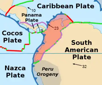 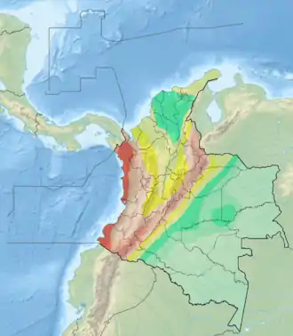 | ||||||||||
|---|---|---|---|---|---|---|---|---|---|---|---|
| Terranes |
| ||||||||||
| Terrane-bounding fault systems |
| ||||||||||
| Intraterrane faults |
| ||||||||||
| Major earthquakes | |||||||||||
| Orogenies |
| ||||||||||
| Other topics | |||||||||||
| Sources |
| ||||||||||
