Rockford, Minnesota
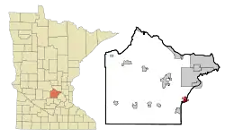
Rockford is a city in Wright and Hennepin counties in the U.S. state of Minnesota. The population was 4,316 at the 2010 census.[7] While Rockford is mainly located within Wright County, a small part of the city extends into Hennepin County. It is part of the Minneapolis–Saint Paul metropolitan statistical area. Minnesota State Highway 55 serves as a main route in the city.
Rockford | |
|---|---|
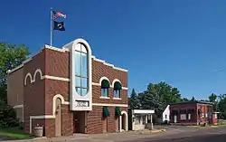 Rockford's Main Street, with city hall on the left | |
 | |
| Coordinates: 45°5′26″N 93°44′20″W | |
| Country | United States |
| State | Minnesota |
| Counties | Wright, Hennepin |
| Government | |
| • Mayor | Renee Hafften [1] |
| Area | |
| • Total | 2.60 sq mi (6.73 km2) |
| • Land | 2.53 sq mi (6.54 km2) |
| • Water | 0.07 sq mi (0.18 km2) |
| Elevation | 915 ft (279 m) |
| Population | |
| • Total | 4,316 |
| • Estimate (2019)[4] | 4,515 |
| • Density | 1,787.41/sq mi (690.08/km2) |
| Time zone | UTC-6 (Central (CST)) |
| • Summer (DST) | UTC-5 (CDT) |
| ZIP code | 55373 |
| Area code(s) | 763 |
| FIPS code | 27-55006[5] |
| GNIS feature ID | 0650206[6] |
| Website | www.cityofrockford.org |
History
Rockford was platted in 1857, and named for a nearby rocky ford on the Crow River.[8] A post office has been in operation at Rockford since 1856.[9] Rockford was incorporated in 1881.[8]
Geography
According to the United States Census Bureau, the city has a total area of 2.67 square miles (6.92 km2); 2.61 square miles (6.76 km2) is land and 0.06 square miles (0.16 km2) is water.[10]
The Crow River is formed at Rockford by the confluence of its North and South Forks.
Education
The main school district is Rockford Public Schools. They include an elementary school (grades preschool to 4th grade) a middle school (grades 5 through 8) and a high school (9th through 12th). The elementary focuses mainly on an arts program, while the middle and high schools put more of an emphasis on technology.[11] The high school has, for the past four years, scored higher than the state average in mathematics.[12] Originally, the Rockford School District was established by the Wright county commissioners on September 6, 1856 and the first school house was constructed by 1860. During the 1960s the school underwent redistricting that gave its current designation as Independent School District # 883.[13]
Demographics
| Historical population | |||
|---|---|---|---|
| Census | Pop. | %± | |
| 1880 | 159 | — | |
| 1900 | 340 | — | |
| 1910 | 287 | −15.6% | |
| 1920 | 324 | 12.9% | |
| 1930 | 287 | −11.4% | |
| 1940 | 270 | −5.9% | |
| 1950 | 369 | 36.7% | |
| 1960 | 533 | 44.4% | |
| 1970 | 730 | 37.0% | |
| 1980 | 2,408 | 229.9% | |
| 1990 | 2,665 | 10.7% | |
| 2000 | 3,484 | 30.7% | |
| 2010 | 4,316 | 23.9% | |
| 2019 (est.) | 4,515 | [4] | 4.6% |
| U.S. Decennial Census | |||
| Wikimedia Commons has media related to Rockford, Minnesota. |
2010 census
As of the census[3] of 2010, there were 4,316 people, 1,622 households, and 1,147 families living in the city. The population density was 1,653.6 inhabitants per square mile (638.5/km2). There were 1,693 housing units at an average density of 648.7 per square mile (250.5/km2). The racial makeup of the city was 94.1% White, 1.0% African American, 0.5% Native American, 1.3% Asian, 0.5% from other races, and 2.5% from two or more races. Hispanic or Latino of any race were 1.9% of the population.
There were 1,622 households, of which 40.3% had children under the age of 18 living with them, 52.7% were married couples living together, 11.2% had a female householder with no husband present, 6.8% had a male householder with no wife present, and 29.3% were non-families. 22.1% of all households were made up of individuals, and 5.5% had someone living alone who was 65 years of age or older. The average household size was 2.66 and the average family size was 3.13.
The median age in the city was 34.7 years. 28.5% of residents were under the age of 18; 7.5% were between the ages of 18 and 24; 31.3% were from 25 to 44; 26% were from 45 to 64; and 6.6% were 65 years of age or older. The gender makeup of the city was 49.4% male and 50.6% female.
2000 census
As of the census of 2000,[5] there were 3,484 people, 1,296 households, and 929 families living in the city. The population density was 2,021.2 people per square mile (782.1/km2). There were 1,333 housing units at an average density of 773.3 per square mile (299.2/km2). The racial makeup of the city was 97.56% White, 0.40% African American, 0.52% Native American, 0.46% Asian, 0.09% Pacific Islander, 0.14% from other races, and 0.83% from two or more races. Hispanic or Latino of any race were 1.00% of the population. 38.1% were of German, 15.0% Norwegian, 8.4% Irish and 6.1% Swedish ancestry.
There were 1,296 households, out of which 44.1% had children under the age of 18 living with them, 55.2% were married couples living together, 11.7% had a female householder with no husband present, and 28.3% were non-families. 21.8% of all households were made up of individuals, and 4.2% had someone living alone who was 65 years of age or older. The average household size was 2.69 and the average family size was 3.17.
In the city, the population was spread out, with 31.9% under the age of 18, 7.7% from 18 to 24, 39.0% from 25 to 44, 16.7% from 45 to 64, and 4.8% who were 65 years of age or older. The median age was 31 years. For every 100 females, there were 99.9 males.
The median income for a household in the city was $51,349, and the median income for a family was $56,607. Males had a median income of $37,112 versus $29,395 for females. The per capita income for the city was $20,675. About 6.5% of families and 6.5% of the population were below the poverty line, including 8.8% of those under age 18 and 13.4% of those age 65 or over.
Notable person
Joel McKinnon Miller- an American actor born in Rockford
References
- http://www.cityofrockford.org/city-departments/city-council/
- "2019 U.S. Gazetteer Files". United States Census Bureau. Retrieved July 26, 2020.
- "U.S. Census website". United States Census Bureau. Retrieved 2012-11-13.
- "Population and Housing Unit Estimates". United States Census Bureau. May 24, 2020. Retrieved May 27, 2020.
- "U.S. Census website". United States Census Bureau. Retrieved 2008-01-31.
- "US Board on Geographic Names". United States Geological Survey. 2007-10-25. Retrieved 2008-01-31.
- "2010 Census Redistricting Data (Public Law 94-171) Summary File". American FactFinder. U.S. Census Bureau, 2010 Census. Retrieved 23 April 2011.
- Upham, Warren (1920). Minnesota Geographic Names: Their Origin and Historic Significance. Minnesota Historical Society. p. 589.
- "Wright County". Jim Forte Postal History. Retrieved 1 August 2015.
- "US Gazetteer files 2010". United States Census Bureau. Archived from the original on 2012-01-25. Retrieved 2012-11-13.
- http://www.rockford.k12.mn.us/se3bin/clientschool.cgi?schoolname=school247%5B%5D
- http://www.schooldigger.com/go/MN/schools/3207001368/school.aspx?entity=42&grade=11
- http://www.mnschools.com/school-finder/school-districts/rockford-883/
External links
Municipalities and communities of Hennepin County, Minnesota, United States | ||
|---|---|---|
| Cities |
|  Map of Minnesota highlighting Hennepin County |
| Unincorporated areas | ||
| Footnotes | ‡This populated place also has portions in an adjacent county or counties | |
| ||
Municipalities and communities of Wright County, Minnesota, United States | ||
|---|---|---|
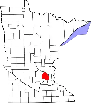
| Cities | 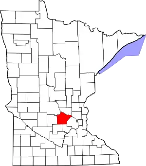 Map of Minnesota highlighting Wright County | |
| Townships | ||
| CDP | ||
| Unincorporated communities | ||
| Ghost town | ||
| Footnotes | ‡This populated place also has portions in an adjacent county or counties | |
| ||