Rosthern
Rosthern is a town at the juncture of Highway 11 and Highway 312 in the central area of Saskatchewan, Canada. It is located roughly halfway between the cities of Prince Albert and Saskatoon.
Rosthern | |
|---|---|
Town | |
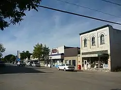 Business District Sixth Street | |
 Rosthern  Rosthern | |
| Coordinates: 52°40′00″N 106°20′00″W | |
| Country | Canada |
| Province | Saskatchewan |
| Rural municipality | Rosthern No. 403 |
| Post office Founded | 1893-09-01 |
| Village established | 1898 |
| Town incorporated | 1903 |
| Government | |
| • Mayor | Dennis Helmuth |
| • M.P. (Carlton Trail—Eagle Creek) | Kelly Block |
| • M.L.A. (Rosthern-Shellbrook) | Scott Moe |
| Area | |
| • Total | 4.31 km2 (1.66 sq mi) |
| Population (2016) | |
| • Total | 1,688 |
| • Density | 392.0/km2 (1,015/sq mi) |
| Time zone | UTC-6 (CST) |
| Postal code | S0K 3R0 |
| Area code(s) | 306 |
| Highways | |
| Website | Official website |
| [1][2][3][4][5] | |
History
Settlers began arriving around 1890, with the establishment of the Qu’Appelle, Long Lake & Saskatchewan Railway to Prince Albert. A post office was established in 1893, and by 1898 the community achieved village status. In 1903, Rosthern was incorporated as a town.[6]
Farmer and author Seager Wheeler lived just outside Rosthern.
There are several apocryphal versions of the story about how the town got its name. One is that in the late 1880s when the railway ran through from Regina to Prince Albert a man by the name of Ross drowned in the creek that flows through the town. Terne is old English for tarn meaning a pool, and the name stuck.[7] In all likelihood, however, the town's name echoes an old world name brought over by a homesick worker on the railroad, in this case that of Rostherne, a village in the United Kingdom.[8]
Demographics
| Canada census – Rosthern community profile | |||
|---|---|---|---|
| 2016 | 2011 | 2006 | |
| Population: | 1,688 (7.4% from 2011) | 1,572 (13.7% from 2006) | 1,382 (-8.1% from 2001) |
| Land area: | 4.31 km2 (1.66 sq mi) | 4.31 km2 (1.66 sq mi) | 4.01 km2 (1.55 sq mi) |
| Population density: | 392.0/km2 (1,015/sq mi) | 365.0/km2 (945/sq mi) | 375.4/km2 (972/sq mi) |
| Median age: | 43.3 (M: 41.8, F: 44.8) | 46.0 (M: 43.6, F: 47.7) | N/A (M: N/A, F: N/A) |
| Total private dwellings: | 747 | 731 | 660 |
| Median household income: | $N/A | $N/A | $N/A |
| References: 2016[9] 2011[10] 2006[11] earlier[12] | |||
- Dominion Land Survey Section 35 - Township 42 - Range 3 West of the 3rd Meridian
Attractions
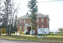

The Seager Wheeler Farm, a National Historic Site of Canada, is 7 km east of Rosthern. The Rosthern Mennonite Heritage Museum (c. 1909-10) is a Municipal Heritage Property on the Canadian Register of Historic Places.[13]
There is also a public library, many parks and walking trails
Recreation
In addition to the nearby Valley Regional Park with an 18-hole grass green golf course, there are two ball-diamonds, two indoor hockey rinks, a curling rink, bowling alley, and three school gyms. A new outdoor swimming pool completed in 2005. Rosthern is also home to the Youth Farm Bible Camp.
Popular sporting activities include baseball, soccer, badminton, basketball, hockey, swimming, volleyball, floor hockey and Tae Kwon Do.
Professional ice hockey players Robyn Regehr and Richie Regehr grew up in Rosthern.
Churches
Rosthern is home to over ten churches including Mennonite, Ukrainian Orthodox, Swedenborgian, Pentecostal, Anglican, Roman Catholic, Ukrainian Catholic, Lutheran, Seventh-day Adventist, Christian & Missionary Alliance, and Baptist.
References
- "2011 Community Profiles". Statistics Canada. Government of Canada. Retrieved 2014-08-02.
- National Archives, Archivia Net, Post Offices and Postmasters
- Government of Saskatchewan, MRD Home. "Municipal Directory System". Retrieved 2014-08-02.
- Canadian Textiles Institute. (2005), CTI Determine your provincial constituency, archived from the original on 2007-09-11
- Commissioner of Canada Elections, Chief Electoral Officer of Canada (2005), Elections Canada On-line
- "Rosthern". Encyclopedia of Saskatchewan. Canadian Plains Research Center, University of Regina. 2006. Retrieved 2016-05-13.
- Russell, E. T. (1975), What's in a Name?, Saskatoon, Sk: Western Producer Prairie Books, p. 276, ISBN 1-894022-92-0
- Barry, Bill (2003), People Places Contemporary Saskatchewan Placenames, Regina, Canada: Print West communications, p. 230, ISBN 1-894022-92-0
- "2016 Community Profiles". 2016 Canadian Census. Statistics Canada. February 21, 2017. Retrieved 2017-06-05.
- "2011 Community Profiles". 2011 Canadian Census. Statistics Canada. July 5, 2013. Retrieved 2012-07-01.
- "2006 Community Profiles". 2006 Canadian Census. Statistics Canada. March 30, 2011. Retrieved 2009-02-24.
- "2001 Community Profiles". 2001 Canadian Census. Statistics Canada. February 17, 2012.
- http://www.historicplaces.ca/visit-visite/affichage-display.aspx?id=1576 Canadian Register of Historic Places.