Eatonia
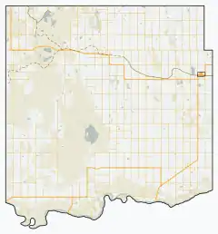
Eatonia is a small town in the Province of Saskatchewan, Canada with a population of 449 people (according to the Canada 2006 Census).[3] The town's economy is based almost exclusively on agriculture. Eatonia is in southwest Saskatchewan at the crossroads of Highways 21 and 44, approximately 44 kilometers southwest of Kindersley and 72 kilometres from the provincial boundary with Alberta. The town is served by Eatonia (Elvie Smith) Municipal Airport.
Eatonia | |
|---|---|
| Town of Eatonia | |
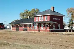 Former Canadian National Railway station in Eatonia | |
 Eatonia  Eatonia | |
| Coordinates: 51°13′16″N 109°23′26″W | |
| Country | Canada |
| Province | Saskatchewan |
| Region | Saskatchewan |
| Census division | 8 |
| Rural Municipality | Chesterfield |
| Founded | 1919 |
| Incorporated | 1954 |
| Government | |
| • Mayor | Steven Schwartz |
| • Administrator | Cheryl Bailey |
| • Governing body | Eatonia Town Council |
| Area | |
| • Total | 1.68 km2 (0.65 sq mi) |
| Elevation | 719.6 m (2,360.9 ft) |
| Population (2006) | |
| • Total | 449 |
| • Density | 266.6/km2 (690/sq mi) |
| Time zone | CST |
| Postal code | S0L 0Y0 |
| Area code(s) | 306 |
| Highways | 21 and 44 |
| Airport | Eatonia (Elvie Smith) Municipal |
| Website | www |
| [1][2] | |
History
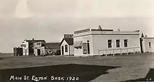
Eatonia was founded in 1919 as a station on the Canadian National Railway and was named after Timothy Eaton, founder of the Eaton's department store chain and catalogue, and to honour his son and heir, John Craig Eaton. The station was originally simply called "Eaton", but there was confusion with nearby Eston, so the name was changed to Eatonia in 1921 ("Eatonia" was the name of an Eaton's brand for clothing and other goods, and "Eatonian" was the name given to long-serving Eaton's employees).
Eatonia was incorporated as a town in 1954. In 1955, the year of Saskatchewan's Golden Jubilee, Eatonia's train station was featured on the cover of the Eaton's catalogue, thus resulting in a classic local image finding its way into homes across the country. The former CN train station is now home to the Wheatland Regional Library (Eatonia Branch). The former station, along with a train caboose and a wood-frame house ordered from the Eaton's catalogue in 1917, comprise the Eatonia Heritage Park, a 0.6-hectare (1.5-acre) Municipal Heritage Property located at the south end of Main Street.[4]
Demographics
The population of Eatonia dropped 5.3% between the 2001 and 2006 censuses.[3]
| Canada census – Eatonia community profile | |||
|---|---|---|---|
| 2011 | 2006 | ||
| Population: | 508 (13.1% from 2006) | 449 (-5.3% from 2001) | |
| Land area: | 1.68 km2 (0.65 sq mi) | 1.68 km2 (0.65 sq mi) | |
| Population density: | 301.6/km2 (781/sq mi) | 266.6/km2 (690/sq mi) | |
| Median age: | 44.5 (M: 41.8, F: 45.3) | 44.9 (M: 42.5, F: 47.5) | |
| Total private dwellings: | 239 | 231 | |
| Median household income: | $37,473 | ||
| References: 2011[5] 2006[6] earlier[7] | |||
Education
Eatonia is home to a kindergarten to Grade 12 public school, Eaton School, which has been home to many successful volleyball, basketball, and football teams throughout its history. It is located within the Sun West School Division.
References
- National Archives, Archivia Net. "Post Offices and Postmasters". Archived from the original on 6 October 2006. Retrieved 6 September 2013.
- Government of Saskatchewan, MRD Home. "Municipal Directory System". Archived from the original on 15 January 2016. Retrieved 6 September 2013.
- Statistics Canada, 2006 Census
- Eatonia Heritage Park. Canadian Register of Historic Places.
- "2011 Community Profiles". 2011 Canadian Census. Statistics Canada. July 5, 2013. Retrieved 2012-08-04.
- "2006 Community Profiles". 2006 Canadian Census. Statistics Canada. March 30, 2011. Retrieved 2011-08-01.
- "2001 Community Profiles". 2001 Canadian Census. Statistics Canada. February 17, 2012.
External links
| Wikimedia Commons has media related to Eatonia, Saskatchewan. |
