Balcarres, Saskatchewan
Balcarres (/bælˈkɑːrəs/ bal-KAR-əs);[6] 2006 population 598) is a town located in Southern Saskatchewan, Canada along Highway 10 and Highway 22, approximately 85 km northeast of Regina. Highway 619 and Highway 310 are nearby highways to this community.
Balcarres | |
|---|---|
Town | |
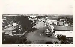
 Balcarres Main Street in 1968 | |
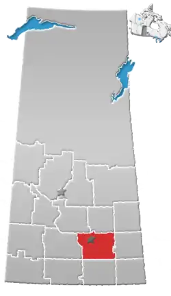
 Balcarres Location of Balcarres in Saskatchewan | |
| Coordinates: 50°48′00″N 103°32′40″W | |
| Country | Canada |
| Province | Saskatchewan |
| Rural Municipalities (R.M.) | Abernethy No. 186 |
| Post Office founded NWT | 1884-04-01 |
| Government | |
| • Mayor | Dwight Dixon |
| • Administrator | Bev Gelech |
| • Governing body | Balcarres Town Council |
| Area | |
| • Total | 1.57 km2 (0.61 sq mi) |
| Population (2011) | |
| • Total | 617 |
| • Density | 392.9/km2 (1,018/sq mi) |
| Time zone | UTC−6 |
| • Summer (DST) | CST |
| Postal code | S0G 0C0 |
| Area code(s) | 306 |
| Highways | Highway 10 Highway 22 Highway 619 Highway 310 |
| Website | Town of Balcarres |
| [1][2][3][4][5] | |
Neighbouring communities include Fort Qu'Appelle to the west, to the southeast Abernethy, and to the north Ituna. The File Hills First Nations of Little Black Bear, Peepeekisis, Okanese, and Star Blanket are also located to the northeast.
History
Balcarres post office was established in the North-West Territories on 1 April 1884.[7] The name originates from the first postmaster, Balcarres Crawford, at the neighbouring community of Indian Head, North-West Territories (now, since 1905, Saskatchewan).[8] [9]
Sites of interest
Motherwell Homestead National Historic Site of Canada is within 8 miles or 12 kilometres of Balcarres.
Valley Centre Recreation Site, Lebret Recreation Site, and Katepwa Point Provincial Park are all within 20 kilometres as well.[10]
Demographics

| Canada census – Balcarres, Saskatchewan community profile | |||
|---|---|---|---|
| 2011 | 2006 | ||
| Population: | 617 (+3.2% from 2006) | 598 (-3.9% from 2001) | |
| Land area: | 1.57 km2 (0.61 sq mi) | 1.57 km2 (0.61 sq mi) | |
| Population density: | 392.9/km2 (1,018/sq mi) | 380.8/km2 (986/sq mi) | |
| Median age: | 47.6 (M: 46.1, F: 49.4) | 43.6 (M: 42.4, F: 45.0) | |
| Total private dwellings: | 261 | 273 | |
| Median household income: | $27,730 | ||
| References: 2011[11] 2006[12] earlier[13] | |||
Geography
- Lat (DMS) 50°48′ N
- Long (DMS) 103°33′ W
- Dominion Land Survey 13-21-12-W2
- Time zone (CST) UTC−6
Amenities
The town is home to several businesses including L&J Country Foods, 2 Chinese restaurants, Balcarres Country Inn, Henry's Family Fair, Baber's Pharmacy, a Royal Bank, as well as many others. Terminal 22, a large inland grain terminal, is located to the west of town along the Canadian National Railway rail line.
Balcarres has a hospital and senior citizens home called the Balcarres Integrated Care Centre or BICC, and an elementary and high school, which educates children from the communities of Balcarres, Abernethy, and the File Hills Indian reserves. There is a United, an Anglican and a Baptist church.
Notable residents
- Walter Dieter of the Peepeekisis Reserve near Balcarres, Saskatchewan. He was the founding Chief of the National Indian Brotherhood in 1968, which is today known as the Assembly of First Nations.
- James Garfield Gardiner was a premier of Saskatchewan and minister in the Canadian Cabinet.
- Mandy Meyer was a guitar player for both Asia and Krokus.
- Kenneth Moore played hockey for Canada in the 1932 Winter Olympics.
- Noel Starblanket of the Star Blanket Cree Nation near Balcarres, Saskatchewan. He was Chief of the National Indian Brotherhood (today known as the Assembly of First Nations).
- Doug Trapp was a professional ice hockey left wing for the Buffalo Sabres.
See also
References
- "2011 Community Profiles". Statistics Canada. Government of Canada. Retrieved 2014-03-20.
- National Archives, Archivia Net. "Post Offices and Postmasters". Archived from the original on 2006-10-06. Retrieved 2014-03-20.
- Government of Saskatchewan, MRD Home. "Municipal Directory System". Archived from the original on 2016-01-15. Retrieved 2014-03-20.
- Canadian Textiles Institute (2005), CTI Determine your provincial constituency, archived from the original on 2007-09-11
- Commissioner of Canada Elections, Chief Electoral Officer of Canada (2005), Elections Canada On-line, archived from the original on 2007-04-21
- The Canadian Press (2017), The Canadian Press Stylebook (18th ed.), Toronto: The Canadian Press
- Library and Archives Canada, National Archives of Canada Archivia Net. "Post Offices and Postmasters". Archived from the original on 2013-01-15. Retrieved 2007-07-02.
- Russell, E.T. (1975), What's in a Name?, Saskatoon: Western Producer Prairie books, ISBN 0-919306-39-X, page 17
- Furrows in Time: A History of Balcarres and District. Balcarres History Book Committee, 1987. ISBN 978-0-919781-37-5.
- Government of Canada. "Geo Names Query". Retrieved 2007-07-02.
- "2011 Community Profiles". 2011 Canadian Census. Statistics Canada. July 5, 2013. Retrieved 2014-03-21.
- "2006 Community Profiles". 2006 Canadian Census. Statistics Canada. March 30, 2011. Retrieved 2009-02-24.
- "2001 Community Profiles". 2001 Canadian Census. Statistics Canada. February 17, 2012.
External links
| North West: Lipton | North: Ituna | North East: Okanese |
| West: Fort Qu'Appelle | Balcarres | East: Melville |
| South West: | South: Katepwa | South East: Abernethy |