Duck Lake, Saskatchewan
Duck Lake is a town in the boreal forest of central Saskatchewan, Canada. Its location is 88 km (55 mi) north of Saskatoon and 44 km (27 mi) south of Prince Albert on highway 11, in the rural municipality of Duck Lake. Immediately to the north of Duck Lake is the south block of the Nisbet Provincial Forest.
Town of Duck Lake | |
|---|---|
Town | |
 Duck Lake Town Office | |
 Location of Duck Lake  Duck Lake, Saskatchewan (Canada) | |
| Coordinates: 52°49′N 106°14′W | |
| Country | Canada |
| Province | Saskatchewan |
| Region | Saskatchewan |
| Post office established | 1879 |
| Village Incorporated | 1898 |
| Town Incorporated | 1911 |
| Government | |
| • Mayor | Donna Piche |
| • Town Administrator | Michelle Zurakowski |
| • Governing body | Duck Lake Town Council |
| Area | |
| • Land | 2.86 km2 (1.10 sq mi) |
| Population (2006) | |
| • Total | 610 |
| • Density | 213.5/km2 (553/sq mi) |
| Time zone | CST |
| Postal code | S0K 1J0 |
| Area code(s) | 306 |
| Highways | Highway 11 Highway 212 |
| Website | Official Site |
| [1][2] | |
It is also the administrative centre of the Beardy's and Okemasis Cree First Nations band government.
Duck Lake was home to one of the last operating Residential Schools in Canada, St. Michael's Indian Residential School (Duck Lake Indian Residential School), which closed in 1996. The disruption in the transmission of Cree language, culture, family systems and policy caused by the St. Michael’s Residential school created immense trauma and suffering through the generations of children and youth today who continue to seek justice by reclaiming their identity, culture, and language while supporting the survivors.
History
Duck Lake was one of the 5 Southbranch Settlements settled by French speaking Métis from Manitoba in the 1860s and 1870s. A Roman Catholic Mission was established in Duck Lake in 1874 by Father André O.M.I. and by 1888 the village had a school, a post office (called Stobart), a flour mill (gristmill) and a trading post. From 1882 to 1905 Duck Lake was within the District of Saskatchewan of the North-West Territories.[3]
In 1885, Duck Lake was the site of the Battle of Duck Lake, a conflict between Métis warriors and the Government of Canada, at the start of the North-West Rebellion. At Duck Lake, the Prince Albert Trail, which ran from Regina to Prince Albert, crossed the Carlton Trail and it marked the halfway point between the Métis headquarters at Batoche and the North-West Mounted Police at Fort Carlton.[4]
Historic Carpenter Gothic style All Saints Anglican Church built in 1896 is a municipal heritage site. Its historic cemetery contains the graves of some of those who fought in the Battle of Duck Lake as well as those of other pioneers of the community.[5]
The 1973 western Alien Thunder was partially filmed here.
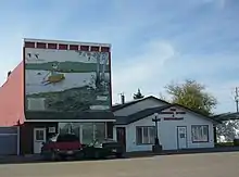 One of the murals documenting the region's history |
 Duck Lake Regional Interpretive Centre |
Demographics
| Canada census – Duck Lake, Saskatchewan community profile | |||
|---|---|---|---|
| 2011 | 2006 | ||
| Population: | 577 (-4.6% from 2006) | 610 (-2.2% from 2001) | |
| Land area: | 2.73 km2 (1.05 sq mi) | 2.86 km2 (1.10 sq mi) | |
| Population density: | 211.6/km2 (548/sq mi) | 213.5/km2 (553/sq mi) | |
| Median age: | 41.2 (M: 41.1, F: 41.2) | 33.8 (M: 33.0, F: 34.3) | |
| Total private dwellings: | 227 | 254 | |
| Median household income: | |||
| References: 2011[6] 2006[7] earlier[8] | |||
Notable people
- Gabriel Dumont - Leader of Métis forces in the North-West Rebellion 1885.
References
- National Archives, Archivia Net. "Post Offices and Postmasters". Archived from the original on 6 October 2006. Retrieved 25 September 2013.
- Government of Saskatchewan, MRD Home. "Municipal Directory System". Archived from the original on 15 January 2016. Retrieved 25 September 2013.
- Henry Thomas McPhillips (1888), McPhillips' alphabetical and business directory of the district of Saskatchewan, N.W.T.: Together with brief historical sketches of Prince Albert, Battleford and the other settlements in the district, 1888 (pages 93-97), Prince Albert, NWT: Henry Thomas McPhillips
- "Canadian Plains Research Center Mapping Division" (PDF). Retrieved 13 Sep 2013.
- Canada's Historic Places: All Saints Anglican Church
- "2011 Community Profiles". 2011 Canadian Census. Statistics Canada. July 5, 2013. Retrieved 2013-09-25.
- "2006 Community Profiles". 2006 Canadian Census. Statistics Canada. March 30, 2011. Retrieved 2013-09-25.
- "2001 Community Profiles". 2001 Canadian Census. Statistics Canada. February 17, 2012.
Further reading
- Barnholden, Michael. (2009). Circumstances Alter Photographs: Captain James Peters' Reports from the War of 1885. Vancouver, BC: Talonbooks. ISBN 978-0-88922-621-0.
External links
Places adjacent to Duck Lake, Saskatchewan | |
|---|---|