Scott, Saskatchewan
Scott is a town in Tramping Lake No. 380, Saskatchewan, Canada. The population was 91 at the 2006 Canada Census. The town is located south of the junction of Highway 14 and Highway 374, approximately 10 km west of the Town of Wilkie. Scott is known as Saskatchewan's smallest town.
Scott, Saskatchewan | |
|---|---|
 Scott, Saskatchewan Location of Scott in Saskatchewan  Scott, Saskatchewan Scott, Saskatchewan (Canada) | |
| Coordinates: 52.293°N 108.951°W | |
| Country | Canada |
| Province | Saskatchewan |
| Region | Southwest |
| Census division | 13 |
| Rural Municipality | Tramping Lake |
| Post office Founded | N/A |
| Incorporated (Village) | N/A |
| Incorporated (Town) | N/A |
| Government | |
| • Mayor | Eric Schell |
| • Town Manager | Stacy Hawkins |
| • Governing body | Scott Town Council |
| Area | |
| • Total | 4.33 km2 (1.67 sq mi) |
| Population (2006) | |
| • Total | 110 |
| • Density | 25.4/km2 (66/sq mi) |
| Time zone | CST |
| Postal code | S0K 4A0 |
| Area code(s) | 306 |
| Highways | Highway 374 |
Demographics
In 2006, Scott had a population of 91 living in 44 dwellings, a -17.3% decrease from 2001. The town has a land area of 4.39 km2 (1.69 sq mi) and a population density of 20.7/km2 (54/sq mi).[1]
Attractions
- Scott Experimental Farm
Climate
Scott experiences a Humid continental climate, with long, extremely cold winters and warm summers. The highest temperature ever recorded in Scott was 39.4 °C (103 °F) on 16 June 1933 and 16 August 2003.[2] The coldest temperature ever recorded was −50.6 °C (−59 °F) on 15 February 1936.[2]
| Climate data for Scott, 1981–2010 normals, extremes 1911–present | |||||||||||||
|---|---|---|---|---|---|---|---|---|---|---|---|---|---|
| Month | Jan | Feb | Mar | Apr | May | Jun | Jul | Aug | Sep | Oct | Nov | Dec | Year |
| Record high °C (°F) | 8.0 (46.4) |
11.7 (53.1) |
23.4 (74.1) |
33.3 (91.9) |
37.2 (99.0) |
39.4 (102.9) |
37.8 (100.0) |
39.4 (102.9) |
36.1 (97.0) |
30.6 (87.1) |
20.0 (68.0) |
13.3 (55.9) |
39.4 (102.9) |
| Average high °C (°F) | −10.0 (14.0) |
−7.6 (18.3) |
−0.4 (31.3) |
10.2 (50.4) |
17.7 (63.9) |
21.7 (71.1) |
23.7 (74.7) |
23.6 (74.5) |
17.2 (63.0) |
9.7 (49.5) |
−3.3 (26.1) |
−8.9 (16.0) |
7.8 (46.0) |
| Daily mean °C (°F) | −15.5 (4.1) |
−12.9 (8.8) |
−5.5 (22.1) |
3.8 (38.8) |
10.8 (51.4) |
15.3 (59.5) |
17.1 (62.8) |
16.5 (61.7) |
10.4 (50.7) |
3.3 (37.9) |
−7.8 (18.0) |
−13.9 (7.0) |
1.8 (35.2) |
| Average low °C (°F) | −20.9 (−5.6) |
−18.2 (−0.8) |
−10.4 (13.3) |
−2.7 (27.1) |
3.8 (38.8) |
8.8 (47.8) |
10.5 (50.9) |
9.4 (48.9) |
3.6 (38.5) |
−3.1 (26.4) |
−12.1 (10.2) |
−18.9 (−2.0) |
−4.2 (24.4) |
| Record low °C (°F) | −48.3 (−54.9) |
−50.6 (−59.1) |
−41.7 (−43.1) |
−30.6 (−23.1) |
−12.5 (9.5) |
−6.7 (19.9) |
−2.8 (27.0) |
−2.8 (27.0) |
−13.3 (8.1) |
−27.8 (−18.0) |
−36.7 (−34.1) |
−44.4 (−47.9) |
−50.6 (−59.1) |
| Average precipitation mm (inches) | 14.9 (0.59) |
9.1 (0.36) |
14.4 (0.57) |
21.6 (0.85) |
36.3 (1.43) |
61.8 (2.43) |
72.1 (2.84) |
45.7 (1.80) |
36.0 (1.42) |
17.9 (0.70) |
22.2 (0.87) |
14.0 (0.55) |
366.2 (14.42) |
| Average rainfall mm (inches) | 0.8 (0.03) |
0.1 (0.00) |
1.1 (0.04) |
14.1 (0.56) |
34.8 (1.37) |
61.8 (2.43) |
72.1 (2.84) |
45.7 (1.80) |
32.9 (1.30) |
12.2 (0.48) |
2.0 (0.08) |
0.1 (0.00) |
277.7 (10.93) |
| Average snowfall cm (inches) | 16.8 (6.6) |
10.2 (4.0) |
14.3 (5.6) |
9.0 (3.5) |
1.5 (0.6) |
0.0 (0.0) |
0.0 (0.0) |
0.0 (0.0) |
1.7 (0.7) |
5.8 (2.3) |
20.8 (8.2) |
14.8 (5.8) |
94.9 (37.4) |
| Mean monthly sunshine hours | 88.7 | 119.3 | 163.8 | 230.6 | 267.6 | 263.5 | 308.6 | 290.4 | 196.4 | 161.0 | 80.7 | 60.8 | 2,238.6 |
| Percent possible sunshine | 34.6 | 42.8 | 44.6 | 55.3 | 55.0 | 52.6 | 61.2 | 63.8 | 51.5 | 48.7 | 30.5 | 28.2 | 47.4 |
| Source: Environment Canada[2] | |||||||||||||
References
- Statistics Canada. "Canada 2006 Census: Scott - Community Profile". Retrieved 2010-09-17.
- "Scott CDA". Canadian Climate Normals 1981−2010. Environment Canada. 29 August 2016. Retrieved February 27, 2016.
Places adjacent to Scott, Saskatchewan | |
|---|---|
| Towns | 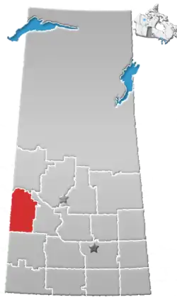 | ||||
|---|---|---|---|---|---|
| Villages | |||||
| Rural municipalities |
| ||||
| First Nations | |||||
| Indian reserves | |||||
| Unincorporated communities |
| ||||