Schwäbisch Gmünd
Schwäbisch Gmünd (German pronunciation: [ˈʃvɛːbɪʃ ˈɡmʏnt], until 1934: Gmünd) is a town in the eastern part of the German state of Baden-Württemberg. With a population of around 60,000, the town is the second largest in the Ostalb district and the whole East Württemberg region after Aalen. The town is a Große Kreisstadt since 1956, i.e. a chief town under district administration; it was the administrative capital of its own rural district until the local government reorganisation on 1 January 1973.
Schwäbisch Gmünd | |
|---|---|
 Clockwise from top: Skyline from Zeiselberg, Heilig Kreuz Münster, Rokokoschlößle, Kornhaus, Rathaus (Mayors Office), Grät, Forum Gold und Silber | |
 Coat of arms | |
Location of Schwäbisch Gmünd within Ostalbkreis district  | |
 Schwäbisch Gmünd  Schwäbisch Gmünd | |
| Coordinates: 48°48′N 9°48′E | |
| Country | Germany |
| State | Baden-Württemberg |
| District | Ostalbkreis |
| Government | |
| • Lord mayor | Richard Arnold |
| Area | |
| • Total | 113.78 km2 (43.93 sq mi) |
| Elevation | 321 m (1,053 ft) |
| Population (2019-12-31)[1] | |
| • Total | 61,137 |
| • Density | 540/km2 (1,400/sq mi) |
| Time zone | UTC+01:00 (CET) |
| • Summer (DST) | UTC+02:00 (CEST) |
| Postal codes | 73525–73529 |
| Dialling codes | 07171 |
| Vehicle registration | AA, GD |
| Website | www.schwaebisch-gmuend.de |
There are some institutions of higher education in the city, most notably the Pädagogische Hochschule Schwäbisch Gmünd (University of Education Schwäbisch Gmünd) and the Landesgymnasium für Hochbegabte (State Highschool for gifted children).
Schwäbisch Gmünd was a self-ruling free imperial city from the 13th century until its annexation to Württemberg in 1802.
Geography

Schwäbisch Gmünd is situated within the northern foothills of the Swabian Jura Mountains on the Rems river, about 50 kilometres (31 miles) east of the state capital Stuttgart. It marks the place where the Josefsbach (Waldstetter-bach) meets the River Rems. The municipal area comprises the localities (Ortschaften) of Bargau, Bettringen, Degenfeld, Großdeinbach, Herlikofen, Hussenhofen, Lindach, Rechberg, Rehnenhof-Wetzgau, Straßdorf, and Weiler.
History
From about AD 85, the Neckar-Odenwald line was part of the northern frontier of the Roman Empire. The Romans built the Limes Germanicus to secure this border; i.e., a line of fortifications at regular distances, which included a small castrum on the site of the present-day Schirenhof field in Schwäbisch Gmünd. A first major settlement in this area arose around the 2nd century AD, when Roman soldiers were deployed near the Upper Germanic limes. From 223 onward, the border lines were assaulted and taken by the Alemanni, who settled down in the areas abandoned by the Romans.
In the 8th century a counterfeit document in the name of Charlemagne, prepared at the Abbey of St Denis near Paris, mentioned a monastic cell called Gamundias built by Abbot Fulrad of St Denis. Whether or not this refers to Gmünd is uncertain. There are no archaeological indications of a cell of this type in Gmünd.


Imperial City of [Swabian] Gmünd Reichsstadt [Schwäbisch] Gmünd | |||||||||
|---|---|---|---|---|---|---|---|---|---|
| 1268–1802 | |||||||||
| Status | Free Imperial City of the Holy Roman Empire | ||||||||
| Capital | Schwäbisch Gmünd | ||||||||
| Government | Republic | ||||||||
| Historical era | Middle Ages | ||||||||
• Founded | mid-12th century | ||||||||
• Gained Reichsfreiheit | 1268 | ||||||||
| 1802 | |||||||||
| |||||||||
The town of Gmünd was first mentioned in an 1162 deed issued at nearby Lorch Abbey, then under the rule of the Hohenstaufen emperor Frederick Barbarossa. The self-proclaimed Stauferstadt achieved the status of an Imperial City in 1268, which it held until 1802, when it was mediatised to the Electorate of Württemberg.
By the end of the 14th century, the name "Etzel castle" was used for the remains of the Roman fort, which had been built to protect the Neckar-Odenwald border of the Roman Empire. In a Baroque chronicle of the city of Schwäbisch Gmünd, written by the councillor Friedrich Vogt (1623–1674), the "Castle" was mentioned in ancient writings as "Etzel castle". Even at the time of Vogt, the Roman remains were cheaper than stones from quarry, and these were thus removed to the ground. Only parts of the moat would still be visible.
The demesne officer, wine expert and archaeologist Carl Friedrich Christoph Gok (1776–1849), a half brother of the poet Friedrich Hölderlin, suspected in 1847, that the alleged castle on the Schirenhof manor had probably once been a Roman fort.[2] The first modern and scientific excavations took place under the guidance of retired army chief of staff of the Württemberg army, General Eduard von Kallee and by Major Heinrich Steimle in the years 1886 to 1888, i.e. before the Empire-Limes-Commission (Reichslimeskommision) had been set up. The so-called Schirenhof Castrum is now part of the UNESCO World Heritage Site Limes Germanicus.
U.S. Army
From 1963 to November 1968, the United States Army's 56th Field Artillery Group, equipped with Pershing missiles, was headquartered at the Hardt Kaserne along with A and D batteries of the 4th Battalion, 41st Artillery. Headquarters & Headquarters Battery then moved down the hill to the Bismarck Kaserne in November 1968. Family housing and the commissary were across the street from the Hardt Kaserne and overlooked a hill above Bismarck Kaserne. There was a school for military dependents (Kindergarten through eighth grade) within walking distance of the family housing. Teachers at this school were credentialed U.S. educators employed by USAREUR (United States Army Europe). In the late 1950s and early 1960s, there were also two local civilians employed to teach the German language (Herr Geis) and German song and dance (Frau Knöpfle). The Hardt Kaserne, formerly Adolf Hitler Kaserne, which was finished in 1937 and used to train officers for the war, was later home to the 4th Battalion, then in 1972 reactivated as 1st battalion 41st Field Artillery, Headquarters, B, C and Service Batteries, Headquarters and Headquarters Battery 56th Field Artillery Brigade, and A Company, 55th Support Battalion. The brigade command had four additional support units: an aviation company, a signal battalion, an infantry battalion, and a forward support battalion. In 1986 the name of the brigade was changed to 56th Field Artillery Command (Pershing).
In March 1955 the 6th Field Artillery Battery arrived from Fort Bragg, NC. This was an Honest John missile battery. A medical battalion and the 567th field artillery battalion (155 mm self-propelled) of the 9th Infantry Division were already there.
The 3d Battalion, 17th Field Artillery was stationed at Hardt Kaserne until late 1963. The unit's mission was reinforcing fire for the 7th Army Light and medium Artillery units. The 8", M-55 Howitzer (SP) was considered the most accurate weapon in the Army's arsenal.
In 1957 The 2 Battalion 16thField Artillery, 4th Armored Division was stationed in Bismark Karserne from 1957 through 1962.
Notable structures

Schwäbisch Gmünd is home to many historically structures and buildings. These include fortifications and civic and religious buildings.

The Rathaus (Town Hall)
Sitting at the south end of the Marktplatz there lies the Rathaus. Before becoming the town hall, the Rathaus was the Debler patrician house and was originally constructed by city architect Johann Michael Keller. In fact, Dominikus Debler, remembered for his work writing the town chronicle, spent his childhood there. However, in 1793 a fire destroyed much of the city between Kornhaus and the Klösterle, leaving city leadership concerned for the safety of the old town hall. The Altes Rathaus (Old Town Hall) was a fachwerk structure reminiscent of Kornhaus that stood between the Marienbrünnen and the present-day Rathaus. Both the initial construction of the building and the conversion of the Debler patrician house into the Rathaus were undertaken by Johann Michael Keller. The Altes Rathaus was deconstructed in two weeks and the only remaining artifacts that can be found on the present-day Rathaus are two of the bells on the bell tower and the clock face.

The Holy Cross Minster

The Holy Cross Minster (Heilig-Kreuz-Münster) is the city's main Catholic church. It stands on the site of a former, much smaller romanesque church. It took about 500 years to be completed, though not consecutively. Initial construction began around 1325 under the leadership of an unknown master builder on what was left of the previous romanesque church, the towers of which were still standing. In 1497, the south tower fell onto the north tower, which knocked over the north tower after a bow connecting the two was removed and in 1515, all repair work was finished.
The Church of Saint John
Sitting on the southeast of the Marktplatz (only 78 meters northeast of the Rathaus), there lies a late Romanesque and neo-Romanesque church called the Johanneskirche, or Church of Saint John, also a Catholic church. As the story of its founding goes, Agnes of Hohenstaufen was out hunting in the Remstal one day and she lost her wedding band. She vowed to have a church built at the site where it would be recovered. Later, the ring was found in the antlers of a fallen stag at the site where the church now sits, and accordingly, Agnes commissioned the construction of the church. A cannonball fired during the Thirty Years' War (1618-1648) remains visibly lodged in the apse of the church.
Institutions
The University of Maryland University College opened a four-year German campus on the Bismarck Kaserne in 1992, which closed in 2002 due to financial difficulties and a lack of students.[6] Festival Europäische Kirchenmusik was established in 1989.
In 2004, the state of Baden-Württemberg opened the Landesgymnasium für Hochbegabte (State Grammar School for the Highly Gifted) in some of the renovated buildings of the Bismarck Kaserne.[7]
One of the oldest universities in the town is the Hochschule für Gestaltung Schwäbisch Gmünd, a design school established in 1776.
The Pädagogische Hochschule Schwäbisch Gmünd, also known as the University of Education Schwäbisch Gmünd, was established in 1825 and is one of six universities in Baden-Württemberg that were established for the sole purpose of educating upcoming teachers.
The European Academy of Surface Technology (EAST) is a scientific and technological institute on surface finishing and electroplating has its headquarters in the city since 1989. EAST grants annually the Schwäbisch Gmünd Prize for young scientists since 2017, in honor to the local tradition of craftsmanship of precious metals.[8]
Local industry
Since the 17th century, Schwäbisch Gmünd has been home to producers of gold and silver handicrafts. An almost forgotten craft was the so-called "Silberporzellan", "Metallporzellan" or "Silberbelagwaren". Today it is known as Silver overlay and Schwäbisch Gmünd was home of inventor Friedrich Deusch who began to decorate not only porcelain but also glass with this unique technique in the end of 19th century. All the important items which are dealt on the art market today are originated in Schwäbisch Gmünd. The town is also home to the Forschungsinstitut für Edelmetalle und Metallchemie, an institute for precious metal work and surface technology. Other important industries include automotive suppliers like Robert Bosch Automotive Steering, manufacturers of machinery and glass, and a large subsidiary of the Swiss toiletries and medicine producer Weleda.[9]
Notable people
- Juri Herter (born 1987), politician
- Peter Parler (c. 1330–1399), architect
- Hans Judenkönig (c. 1450–1526), lutenist
- Jerg Ratgeb (c. 1480–1526), painter
- Hans Baldung (1484/85–1545), painter
- Veit Warbeck (c. 1490–1534), scientist and diplomat
- Jakob Woller (c. 1510–1564), sculptor
- August Franz Josef Karl Mayer (1787-1865), physician, anatomist and physiologist
- Emanuel Leutze (1816–1868), history painter[10]
- Johannes Scherr (1817–1886), novelist and literary critic
- Hermann Pleuer (1863-1911), Impressionist and landscape artist
- Robert von Ostertag (1864-1940), veterinarian
- Emil Molt (1876-1936), businessman, social reformer and anthroposophist
- Hermann Weller (1878-1956), Indiologist and neo-Latin poet
- Alfred Haag (1904–1982), politician
- Lina Haag (1907–2012), anti-Fascist activist
- Theodor Schwenk (1910–1986), anthroposophist, engineer and pioneering water researcher
- Karl Ramsayer (1911–1982), geodesist
- Albert Bürger (1913–1996), Luftwaffe officer and fireman
- Karl Leiberich (1920-2012), Army Officer
- Hartmut Esslinger (born 1944), Industrial designer
- Norbert Barthle (born 1952), politician
- Michael Braungart (born 1958), chemist
- Aron Strobel (born 1958), lead guitarist for Münchener Freiheit
- Richard Arnold (born 1959), politician
- Uwe Messerschmidt (born 1962), track cyclist and road bicycle racer
- Biljana Sečivanović (born 1976), Serbian pop-folk singer
- Simon Tischer (born 1982), volleyball player
- Andreas Hofmann (born 1986), football player
- Daniel Hägele (born 1989), football player
- Julian Grupp (born 1991), football player
- Carina Vogt (born 1992), ski jumper
Twin towns – sister cities

Schwäbisch Gmünd is twinned with:[11]
 Barnsley, United Kingdom, since 1971
 Antibes, France, since 1976
 Bethlehem, United States, since 1991
 Székesfehérvár, Hungary, since 1991
 Faenza, Italy, since 2001
References
- "Bevölkerung nach Nationalität und Geschlecht am 31. Dezember 2019". Statistisches Landesamt Baden-Württemberg (in German). September 2020.
- Hans Ulrich Nuber: Schwäbisch Gmünd in frühgeschichtlicher Zeit. In: Geschichte der Stadt Schwäbisch Gmünd. Konrad Theiss Verlag, Stuttgart 1984, ISBN 3-8062-0399-7, S. 26.
- "Flash flood devastates German town Schwabisch Gmund, killing four". www.9news.com.au. Retrieved 28 December 2017.
- "Heavy rains cause deadly flooding in southern Germany". Dw.com. 30 May 2016. Retrieved 28 December 2017.
- "Four feared dead as Germany hit by massive floods and thunderstorms". Independent.ie. Retrieved 28 December 2017.
- "Schwäbisch Gmünd Closure - UMUC". 23 December 2003. Archived from the original on 23 December 2003. Retrieved 28 December 2017.
- Landesgymnasium für Hochbegabte Schwäbisch Gmünd Archived 17 August 2007 at the Wayback Machine
- Leisner, P. (June 2017). "EAST Prizes for excellence in surface technology". Transactions of the IMF. 95 (4): 183–184. doi:10.1080/00202967.2017.1327260.
- See Weleda (Unternehmen) on the German Wikipedia
- Marter, Joan M. (2011). The Grove Encyclopedia of American Art. Oxford University Press. p. 144. ISBN 978-0-19-533579-8.
- "Schwäbisch Gmünds Partnerstädte". schwaebisch-gmuend.de (in German). Schwäbisch Gmünd. Retrieved 28 November 2019.
External links
| Wikimedia Commons has media related to Schwäbisch Gmünd. |
| Wikisource has the text of the 1911 Encyclopædia Britannica article Gmünd. |
- Official website
 (in German)
 - Schwäbisch Gmünd Live Webcam
- Schwäbisch Gmünd — The oldest Staufertown (in English)
- Schwäbisch Gmünd portal, links, image gallery, artists (in English and German)
- Wikisource (German) - some hundred of PD texts
| Imperial cities |  | |
|---|---|---|
| Nobility | St George's Shield (Gesellschaft von Sanktjörgenschild) | |
| Territories | ||
| Ecclesiastical | 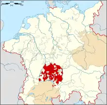 | |
|---|---|---|
| Secular | ||
| Prelates | ||
| Counts Lords |
| |
| Cities | ||
Circles est. 1500: Bavarian, Swabian, Upper Rhenish, Lower Rhenish–Westphalian, Franconian, (Lower) Saxon Circles est. 1512: Austrian, Burgundian, Upper Saxon, Electoral Rhenish · Unencircled territories | ||
Towns and municipalities in Ostalb (district) | ||
|---|---|---|
| ||
| Authority control |
|---|