Stara Pazova
Stara Pazova (Serbian Cyrillic: Стара Пазова, pronounced [stâːraː pâzɔv̞a]) is a town and municipality located in the Srem District of the autonomous province of Vojvodina, Serbia. The town has a population of 18,602, while Stara Pazova municipality has 65,792 inhabitants. The entrance into town from Inđija lies on 45th parallel north, it is half-way between the North pole and the equator.
Stara Pazova
| |
|---|---|
Town and municipality | |
Panorama of Stara Pazova town | |
 Coat of arms | |
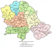
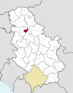 Location of the municipality of Stara Pazova within Serbia | |
| Coordinates: 44°59′N 20°10′E | |
| Country | |
| Province | |
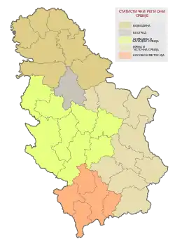
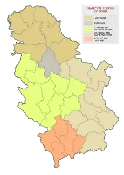
| Region | Syrmia |
| District | Srem |
| Municipality | Stara Pazova |
| Settlements | 9 |
| Government | |
| • Mayor | Đorđe Radinović (SNS) |
| Area | |
| • Town | 64.73 km2 (24.99 sq mi) |
| • Municipality | 344.49 km2 (133.01 sq mi) |
| Elevation | 82 m (269 ft) |
| Population (2011 census)[2] | |
| • Town | 18,602 |
| • Town density | 290/km2 (740/sq mi) |
| • Municipality | 65,792 |
| • Municipality density | 190/km2 (490/sq mi) |
| Time zone | UTC+1 (CET) |
| • Summer (DST) | UTC+2 (CEST) |
| Postal code | 22300 |
| Area code | +381(0)22 |
| Car plates | ST |
Name
In Serbian, the town is known as Stara Pazova (Стара Пазова), formerly also Pazova (Пазова); in Slovak as Stará Pazova; in German as Alt-Pasua, Alt-Pazua or Pazua; and in Hungarian as Ópazova.
History
During the Ottoman administration (16th-18th century), Pazova was populated by ethnic Serbs and was part of the Ottoman Sanjak of Syrmia. In 1718, the town became part of the Habsburg Monarchy. In the 18th century (after 1760) Lutheran Slovaks settled in Pazova, and in 1791 Germans arrived here as well. The Germans lived in a separate settlement known as Nova Pazova ("New Pazova"), thus the old settlement was named Stara Pazova ("Old Pazova"). Until the second half of the 20th century, Slovaks were largest ethnic group in the town of Stara Pazova, while largest ethnic group in the surrounding municipality were Serbs.
For most part of the Habsburg rule, Stara Pazova was part of the Habsburg Military Frontier (abolished in 1882), while in 1848-1849 it was part of Serbian Vojvodina. In the late 19th and early 20th century, Stara Pazova was a district centre in the Syrmia County (part of the Kingdom of Croatia-Slavonia, Kingdom of Hungary and Austria-Hungary). According to the 1910 census, the population of the Stara Pazova municipality numbered 46,430 inhabitants, of whom 24,262 spoke Serbian, 9,348 German, 5,779 Slovak, and 5,670 Croatian. The town itself had a Slovak majority in 1910.
After 1918, the town was part of the Kingdom of Serbs, Croats and Slovenes and subsequent South Slavic states. According to the 1971 census, 56% of the population of the town of Stara Pazova were Slovaks. Today, the largest ethnic group in both the town and the municipality, are Serbs.
Inhabited places
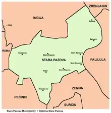
Stara Pazova municipality includes the town of Stara Pazova and the following settlements:
Demographics
| Year | Pop. | ±% p.a. |
|---|---|---|
| 1948 | 30,547 | — |
| 1953 | 33,352 | +1.77% |
| 1961 | 41,036 | +2.63% |
| 1971 | 43,447 | +0.57% |
| 1981 | 52,566 | +1.92% |
| 1991 | 57,291 | +0.86% |
| 2002 | 67,576 | +1.51% |
| 2011 | 65,792 | −0.30% |
| Source: [3] | ||
According to the 2011 census results, the municipality of Stara Pazova has a population of 65,792 inhabitants.
Ethnic groups
All settlements in the municipality have an ethnic Serb majority. The ethnic composition of the municipality:[4]
| Ethnic group | Population | % |
|---|---|---|
| Serbs | 54,516 | 82.86% |
| Slovaks | 5,212 | 7.92% |
| Croats | 1,336 | 2.03% |
| Romani | 1,193 | 1.81% |
| Yugoslavs | 206 | 0.31% |
| Montenegrins | 122 | 0.19% |
| Macedonians | 179 | 0.27% |
| Hungarians | 131 | 0.20% |
| Muslims | 83 | 0.13% |
| Russians | 52 | 0.08% |
| Ukrainians | 47 | 0.07% |
| Slovenes | 27 | 0.04% |
| Germans | 27 | 0.04% |
| Gorani | 21 | 0.03% |
| Bosniaks | 17 | 0.03% |
| Bulgarians | 12 | 0.02% |
| Others | 2,611 | 3.97% |
| Total | 65,792 |
Economy
The following table gives a preview of total number of registered people employed in legal entities per their core activity (as of 2018):[5]
| Activity | Total |
|---|---|
| Agriculture, forestry and fishing | 297 |
| Mining and quarrying | 13 |
| Manufacturing | 7,474 |
| Electricity, gas, steam and air conditioning supply | 94 |
| Water supply; sewerage, waste management and remediation activities | 281 |
| Construction | 939 |
| Wholesale and retail trade, repair of motor vehicles and motorcycles | 5,548 |
| Transportation and storage | 2,311 |
| Accommodation and food services | 593 |
| Information and communication | 165 |
| Financial and insurance activities | 145 |
| Real estate activities | 63 |
| Professional, scientific and technical activities | 548 |
| Administrative and support service activities | 1,325 |
| Public administration and defense; compulsory social security | 583 |
| Education | 796 |
| Human health and social work activities | 811 |
| Arts, entertainment and recreation | 238 |
| Other service activities | 320 |
| Individual agricultural workers | 404 |
| Total | 22,950 |
Gallery
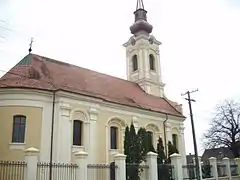 The Serbian Orthodox church.
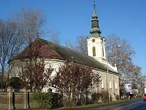 The Slovak Evangelical church.
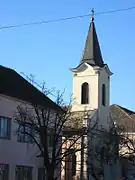 The Catholic church.
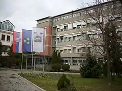 Town Hall
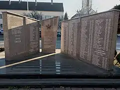 Monument to the victims of fascism and wars of the 90s
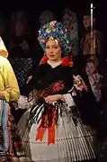 Girl in Slovak Folk Wedding Costume
International relations
See also
- List of places in Serbia
- List of cities, towns and villages in Vojvodina
References
- "Municipalities of Serbia, 2006". Statistical Office of Serbia. Retrieved 2010-11-28.
- "2011 Census of Population, Households and Dwellings in the Republic of Serbia: Comparative Overview of the Number of Population in 1948, 1953, 1961, 1971, 1981, 1991, 2002 and 2011, Data by settlements" (PDF). Statistical Office of Republic Of Serbia, Belgrade. 2014. ISBN 978-86-6161-109-4. Retrieved 2014-06-27.
- "2011 Census of Population, Households and Dwellings in the Republic of Serbia" (PDF). stat.gov.rs. Statistical Office of the Republic of Serbia. Retrieved 19 August 2017.
- "ETHNICITY Data by municipalities and cities" (PDF). stat.gov.rs. Statistical Office of the Republic of Serbia. Retrieved 22 February 2018.
- "MUNICIPALITIES AND REGIONS OF THE REPUBLIC OF SERBIA, 2019" (PDF). stat.gov.rs. Statistical Office of the Republic of Serbia. 25 December 2019. Retrieved 28 December 2019.
- Slobodan Ćurčić, Broj stanovnika Vojvodine, Novi Sad, 1996.
- Dr. Dušan J. Popović, Srbi u Vojvodini, knjiga 1, Novi Sad, 1990.
- Borislav Jankulov, Pregled kolonizacije Vojvodine u XVIII i XIX veku, Novi Sad - Pančevo, 2003.
- Dr. Branislav Bukurov, Bačka, Banat i Srem, Novi Sad, 1978.
External links
| Wikimedia Commons has media related to Stara Pazova. |
- Official website
- Radio and TV station Stara Pazova (in Serbian)