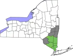
Sullivan County, New York
Sullivan County is a county in the U.S. state of New York. As of the 2010 census, the population was 77,547.[1] The county seat is Monticello.[2] The county's name honors Major General John Sullivan, who was a hero in the American Revolutionary War.
Sullivan County | |
|---|---|
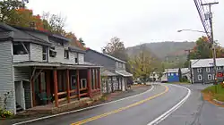
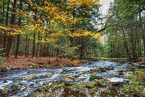 Stream in the hamlet of Rock Hill | |
 Flag  Seal | |
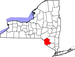 Location within the U.S. state of New York | |
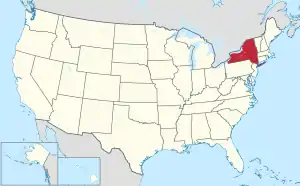 New York's location within the U.S. | |
| Coordinates: 41.72°N 74.76°W | |
| Country | |
| State | |
| Founded | 1809 |
| Named for | John Sullivan |
| Seat | Monticello |
| Largest village | Monticello |
| Area | |
| • Total | 997 sq mi (2,580 km2) |
| • Land | 968 sq mi (2,510 km2) |
| • Water | 29 sq mi (80 km2) 2.9% |
| Population | |
| • Estimate (2019) | 75,432 |
| • Density | 78/sq mi (30/km2) |
| Time zone | UTC−5 (Eastern) |
| • Summer (DST) | UTC−4 (EDT) |
| Congressional district | 19th |
| Website | co |
The county was the site of hundreds of Borscht Belt hotels and resorts, which had their heyday from the 1920s through the 1970s.
In 2010, the county's center of population was at the southern edge of Sullivan County.[3]
History
.jpg.webp)
When the Province of New York established its first twelve counties in 1683, the present Sullivan County was part of Ulster County. In 1809, Sullivan County was split from Ulster County.
In the late 19th century, the Industrial Revolution and the advent of factories driven by water power along the streams and rivers led to an increase in population attracted to the jobs. Hamlets enlarged into towns. As industry restructured, many of those jobs left before the middle of the twentieth century. The economy changed again after that, shifting to a more tourist-based variety and benefiting from resorts established by European Jewish immigrants and their descendants in what became called the Borscht Belt of the 20th century. Resort hotels featured a wide variety of entertainers, some nationally known. At the beginning of this period, visitors traveled to the area by train, and later by automobile. The area's natural resources also provided a setting for numerous summer camps frequented by the children of immigrants and their descendants.
Geography

According to the U.S. Census Bureau, the county has a total area of 997 square miles (2,580 km2), of which 968 square miles (2,510 km2) is land and 29 square miles (75 km2) (2.9%) is water.[4]
Sullivan County is in the southern part of New York State, southeast of Binghamton and southwest of Albany. It is separated from Pennsylvania along its southwest boundary by the Delaware River.
The county, which starts about 70 miles northwest of New York City, is in the Catskill Mountains. Its northeastern corner is within the Catskill Park.
The highest point in the county is a 3,118-foot (950 m) peak unofficially known as Beech Mountain, near Hodge Pond, a subsidiary summit to Mongaup Mountain[5] across the Ulster County line. The lowest point is along the Delaware River.[6]
Adjacent counties
- Delaware County - north
- Ulster County - northeast
- Orange County - southeast
- Pike County, Pennsylvania - southwest
- Wayne County, Pennsylvania - west
Demographics
| Historical population | |||
|---|---|---|---|
| Census | Pop. | %± | |
| 1810 | 6,108 | — | |
| 1820 | 8,900 | 45.7% | |
| 1830 | 12,364 | 38.9% | |
| 1840 | 15,629 | 26.4% | |
| 1850 | 25,088 | 60.5% | |
| 1860 | 32,385 | 29.1% | |
| 1870 | 34,550 | 6.7% | |
| 1880 | 32,491 | −6.0% | |
| 1890 | 31,031 | −4.5% | |
| 1900 | 32,306 | 4.1% | |
| 1910 | 33,808 | 4.6% | |
| 1920 | 33,163 | −1.9% | |
| 1930 | 35,272 | 6.4% | |
| 1940 | 37,901 | 7.5% | |
| 1950 | 40,731 | 7.5% | |
| 1960 | 45,272 | 11.1% | |
| 1970 | 52,580 | 16.1% | |
| 1980 | 65,155 | 23.9% | |
| 1990 | 69,277 | 6.3% | |
| 2000 | 73,966 | 6.8% | |
| 2010 | 77,547 | 4.8% | |
| 2019 (est.) | 75,432 | [7] | −2.7% |
| U.S. Decennial Census[8] 1790-1960[9] 1900-1990[10] 1990-2000[11] 2010-2013[1] 2018[12] | |||
As of the 2000 Census,[13] there were 73,966 people, 27,661 households, and 18,311 families residing in the county. The population density was 76 people per square mile (29/km2). There were 44,730 housing units at an average density of 46 per square mile (18/km2). The racial makeup of the county was 85.31% White, 8.51% Black or African American, 0.27% Native American, 1.12% Asian, 0.04% Pacific Islander, 2.89% from other races, and 1.87% from two or more races. 9.25% of the population were Hispanic or Latino of any race. 16.6% were of German, 13.9% Irish, 12.5% Italian, 7.3% American and 6.2% English ancestry according to Census 2000. 86.6% spoke English, 7.4% Spanish and 1.0% German as their first language. A small population of Russians, late twentieth-century immigrants, live in the villages. There are a few persons in Sullivan and nearby counties who are of mixed Dutch and Mohawk or Lenni-Lenape ancestry in this region of upstate New York, the legacy of indigenous peoples in the region and the New Netherlands colonial era in the 17th century.
There were 27,661 households, out of which 31.30% had children under the age of 18 living with them, 50.10% were married couples living together, 11.40% had a female householder with no husband present, and 33.80% were non-families. 27.90% of all households were made up of individuals, and 11.40% had someone living alone who was 65 years of age or older. The average household size was 2.50 and the average family size was 3.05.
In the county, the population was spread out, with 24.90% under the age of 18, 7.30% from 18 to 24, 28.10% from 25 to 44, 25.40% from 45 to 64, and 14.30% who were 65 years of age or older. The median age was 39 years. For every 100 females, there were 103.60 males. For every 100 females age 18 and over, there were 102.80 males.
The median income for a household in the county was $36,998, and the median income for a family was $43,458. Males had a median income of $36,110 versus $25,754 for females. The per capita income for the county was $18,892. About 11.60% of families and 17.40% of the population were below the poverty line, including 21.60% of those under age 18 and 10.70% of those age 65 or over.
National protected area
Government and politics
| Year | Republican | Democratic | Third parties |
|---|---|---|---|
| 2020 | 53.8% 18,665 | 44.6% 15,489 | 1.6% 543 |
| 2016 | 53.2% 15,931 | 42.0% 12,568 | 4.9% 1,456 |
| 2012 | 44.7% 12,705 | 53.7% 15,268 | 1.6% 442 |
| 2008 | 44.6% 13,900 | 54.0% 16,850 | 1.4% 433 |
| 2004 | 49.5% 15,319 | 48.6% 15,034 | 2.0% 613 |
| 2000 | 44.5% 12,703 | 50.3% 14,348 | 5.2% 1,477 |
| 1996 | 33.0% 9,321 | 53.3% 15,052 | 13.7% 3,871 |
| 1992 | 36.0% 11,396 | 43.4% 13,717 | 20.6% 6,522 |
| 1988 | 57.0% 15,713 | 42.2% 11,635 | 0.8% 220 |
| 1984 | 63.1% 18,037 | 36.6% 10,475 | 0.3% 78 |
| 1980 | 55.4% 15,089 | 35.1% 9,553 | 9.5% 2,576 |
| 1976 | 48.8% 13,709 | 50.5% 14,189 | 0.7% 198 |
| 1972 | 63.2% 17,035 | 36.6% 9,847 | 0.2% 56 |
| 1968 | 48.2% 11,657 | 44.9% 10,860 | 7.0% 1,681 |
| 1964 | 32.3% 8,006 | 67.5% 16,728 | 0.2% 41 |
| 1960 | 54.4% 13,744 | 45.4% 11,486 | 0.2% 49 |
| 1956 | 63.9% 15,845 | 36.1% 8,937 | 0.0% 0 |
| 1952 | 63.3% 14,926 | 35.7% 8,421 | 1.1% 247 |
| 1948 | 53.2% 11,253 | 36.2% 7,654 | 10.6% 2,245 |
| 1944 | 55.8% 11,258 | 43.8% 8,836 | 0.4% 73 |
| 1940 | 54.6% 11,877 | 45.0% 9,785 | 0.4% 76 |
| 1936 | 48.8% 9,757 | 49.6% 9,908 | 1.6% 317 |
| 1932 | 44.8% 8,294 | 52.2% 9,656 | 3.1% 567 |
| 1928 | 61.3% 10,331 | 36.8% 6,207 | 1.9% 323 |
| 1924 | 56.9% 7,734 | 29.8% 4,057 | 13.3% 1,813 |
| 1920 | 64.5% 8,029 | 29.1% 3,623 | 6.5% 806 |
| 1916 | 53.1% 4,340 | 44.7% 3,659 | 2.2% 182 |
| 1912 | 37.6% 3,039 | 47.8% 3,864 | 14.7% 1,189 |
| 1908 | 52.5% 4,593 | 44.7% 3,911 | 2.8% 242 |
| 1904 | 54.4% 4,452 | 43.7% 3,582 | 1.9% 155 |
| 1900 | 53.9% 4,393 | 44.5% 3,625 | 1.6% 130 |
| 1896 | 58.4% 4,589 | 39.1% 3,073 | 2.6% 202 |
| 1892 | 48.3% 3,664 | 47.0% 3,567 | 4.7% 358 |
| 1888 | 49.7% 3,860 | 48.3% 3,757 | 2.0% 156 |
| 1884 | 45.3% 3,332 | 49.1% 3,607 | 5.6% 415 |
Sullivan County is a swing county, backing the national winner in all but two presidential elections from 1952 to the present. In 2004, Republican George W. Bush defeated Democrat John Kerry by a margin of 49.47% to 48.55%, or a difference of 285 votes.[15] In 2008, however, it was won by Democrat Barack Obama over Republican John McCain by a margin of 54% to 45%.[16] Then, in 2016, the county voted for Republican Donald Trump over Democrat Hillary Clinton by a margin of 53% to 42%.[17]
There are thirty-six town and village courts in Sullivan County.[18]
Legislative authority is vested in the county legislature which consists of nine members, each elected from single member districts. Currently, there are five Republican and four Democrats.
| District | Legislator | Title | Party |
|---|---|---|---|
| 1 | Scott B. Samuelson | Democratic | |
| 2 | Nadia Rajsz | Vice Chair | Democratic |
| 3 | Mark McCarthy | Democratic | |
| 4 | Catherine Owens | Republican | |
| 5 | Terri Ward | Republican | |
| 6 | Luis Alvarez | Chair | Republican |
| 7 | Joseph Perrello | Republican | |
| 8 | Ira Steingart | Minority Leader | Democratic |
| 9 | Alan Sorensen | Republican | |
Education
Public school districts
Higher education
- Sullivan County Community College is located in the hamlet of Loch Sheldrake in the town of Fallsburg.
Transportation
Sullivan County has services provided by Coach USA to New York City. It also has some local service provided by the county itself, as well as community organizations.[19][20][21]
Sullivan County International Airport is located in Bethel.
Tourism
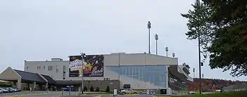
Sullivan County has been a popular vacation spot since the 19th Century, with mountain climbing, boating, and other outdoor activities, as well as the Monticello Raceway being among the attractions. The majority of the tourism occurs in the summer months. It was the site of the hundreds of resort complexes of the Borscht Belt (with their golf courses, social events, and entertainers), between the 1920s and 1970s.
Many famous comedians tested their material and performed regularly at Borscht Belt hotels, including Milton Berle, Mel Brooks, and Henny Youngman. Eddie Fisher performed often at Grossinger's, where in 1955 he married Debbie Reynolds.
Sullivan County was the site of the 1969 Woodstock Festival located at the present-day Bethel Woods Center for the Arts. During the period August 15–18, 1969, approximately 500,000 people gathered in Sullivan County's Town of Bethel at Max Yasgur's farm to attend the Woodstock Festival. The entertainers included The Who; the Grateful Dead; Jefferson Airplane; The Band; Canned Heat; Joan Baez; Arlo Guthrie; Crosby, Stills, Nash and Young; Janis Joplin; Santana; Sly and the Family Stone; Blood, Sweat and Tears; Jimi Hendrix; and Richie Havens.
Bethel Woods Center for the Arts, which also includes a museum of the sixties and Woodstock, holds many concerts and other events throughout the year.
Other notable cultural destinations include the CAS Arts Center, a multi-arts exhibit space and education center run by the Catskill Art Society in Livingston Manor, New York, the NaCl Theatre, a professional regional theater company focusing on experimental work in Highland Lake, and the Delaware Valley Arts Alliance (DVAA) which serves as the Arts Council for Sullivan County and is located in Narrowsburg. DVAA offers two art galleries, performing arts and cultural programming, grant opportunities for artists and nonprofits, the Big Eddy Film Festival, and Riverfest.
Communities

Towns
Villages
- Bloomingburg
- Jeffersonville
- Liberty
- Monticello (county seat)
- Woodridge
- Wurtsboro
Census-designated places
- Barryville
- Bridgeville
- Callicoon
- Eldred
- Fallsburg
- Grahamsville
- Hankins
- Hortonville
- Hurleyville
- Kauneonga Lake
- Kiamesha Lake
- Lake Huntington
- Livingston Manor
- Loch Sheldrake
- Mongaup Valley
- Mountain Dale
- Narrowsburg
- Rock Hill
- Roscoe
- Smallwood
- South Fallsburg
- Swan Lake
- White Lake
- Woodbourne
- Wurtsboro Hills
See also
References
- Notes
- "State & County QuickFacts". United States Census Bureau. Retrieved October 13, 2013.
- "Find a County". National Association of Counties. Retrieved 2011-06-07.
- "Centers of Population by State: 2010". United States Census Bureau. Retrieved April 5, 2014.
- "2010 Census Gazetteer Files". United States Census Bureau. August 22, 2012. Archived from the original on May 19, 2014. Retrieved January 7, 2015.
- "Beech Mountain - Peakbagger.com". www.peakbagger.com. Retrieved 2019-10-01.
- "Sullivan County". www.dianebutlerrealestate.com. Retrieved 2020-05-19.
- "QuickFacts Sullivan County, New York". United States Census Bureau. Retrieved August 1, 2020.
- "U.S. Decennial Census". United States Census Bureau. Retrieved January 7, 2015.
- "Historical Census Browser". University of Virginia Library. Retrieved January 7, 2015.
- "Population of Counties by Decennial Census: 1900 to 1990". United States Census Bureau. Retrieved January 7, 2015.
- "Census 2000 PHC-T-4. Ranking Tables for Counties: 1990 and 2000" (PDF). United States Census Bureau. Retrieved January 7, 2015.
- "Sullivan County, New York". United States Census Bureau. Retrieved October 13, 2019.
- "U.S. Census website". United States Census Bureau. Retrieved 2008-01-31.
- Leip, David. "Dave Leip's Atlas of U.S. Presidential Elections". uselectionatlas.org. Retrieved 19 April 2018.
- Sullivan County Evaluation (PDF), National League of Defenders Association, January 2009, p. 8, archived from the original (PDF) on 2011-07-27
- "Archived copy". Archived from the original on 2013-11-11. Retrieved 2013-12-19.CS1 maint: archived copy as title (link)
- County, Sullivan. "Sullivan County > Departments > Transportation". www.co.sullivan.ny.us. Retrieved 19 April 2018.
- http://www.coachusa.com/CoachUsaAssets/files/98/HudsonSL.pdf
External links
| Wikimedia Commons has media related to Sullivan County, New York. |
| Wikivoyage has a travel guide for Sullivan County, New York. |
- Sullivan County, New York
- Sullivan County Chamber of Commerce
- Sullivan County at Curlie
- Sullivan County information
- Sullivan County information
- Sullivan County Historical Society
- Sullivan County history
- Sullivan County Emergency Services
- Early Sullivan County History
- Map of Fire Stations in Sullivan County
Places adjacent to Sullivan County, New York | ||||||||||
|---|---|---|---|---|---|---|---|---|---|---|
| ||||||||||
Municipalities and communities of Sullivan County, New York, United States | ||
|---|---|---|
| Towns | | |
| Villages | ||
| CDPs |
| |
| Other hamlets | ||
| Indian reservation | ||
| Footnotes | ‡This populated place also has portions in another county or counties. | |
| ||
| |||||||||
| |||||||||
| Authority control |
|---|