Rensselaer County, New York
Rensselaer County /rɛnsəˈlɪər/ is a county in the U.S. state of New York. As of the 2010 census, the population was 159,429.[1] Its county seat is Troy.[2] The county is named in honor of the family of Kiliaen van Rensselaer, the original Dutch owner of the land in the area.
Rensselaer County | |
|---|---|
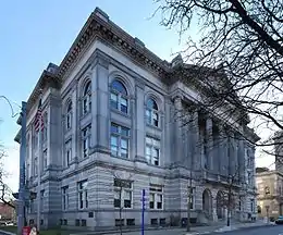
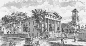 Rensselaer County Courthouse | |
 Flag  Seal | |
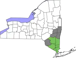
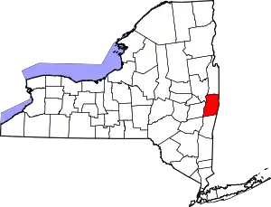 Location within the U.S. state of New York | |
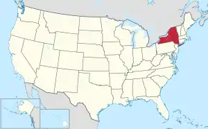 New York's location within the U.S. | |
| Coordinates: 42°42′36″N 73°29′24″W | |
| Country | |
| State | |
| Founded | 1791 |
| Named for | Kiliaen van Rensselaer |
| Seat | Troy |
| Largest city | Troy |
| Area | |
| • Total | 665 sq mi (1,720 km2) |
| • Land | 652 sq mi (1,690 km2) |
| • Water | 13 sq mi (30 km2) 1.9% |
| Population (2010) | |
| • Total | 159,429 |
| • Density | 244/sq mi (94/km2) |
| Time zone | UTC−5 (Eastern) |
| • Summer (DST) | UTC−4 (EDT) |
| Congressional districts | 19th, 20th |
| Website | www |
Rensselaer County is part of the Albany-Schenectady-Troy, NY Metropolitan Statistical Area.
History
The area that is now Rensselaer County was inhabited by the Algonquian-speaking Mohican Indian tribe at the time of European encounter. Kiliaen van Rensselaer, a Dutch jeweler and merchant, purchased the area in 1630 and incorporated it in his patroonship Rensselaerswyck. (It was part of the Dutch colony New Netherland).[3]
The land passed into English rule in 1664; the Dutch regained control in 1673, but the English took it back in 1674. Until 1776, the year of American independence, the county was under English or British control.[4] The county was not organized as a legal entity until after the Revolution in 1791, when it was created from an area that was originally part of the very large Albany County.[5][6]
In 1807, in a county re-organization, the rural sections of Troy were set off as Towns, and the city was incorporated. The two towns created were Brunswick (named for Duke Friedrich Wilhelm of Braunschweig-Lüneburg) and Grafton (named for Henry FitzRoy, 5th Duke of Grafton). A third town, Philipstown, was set off in 1806. In 1808 it was renamed Nassau after the duke of that area.
Geography
According to the U.S. Census Bureau, the county has a total area of 665 square miles (1,720 km2), of which 652 square miles (1,690 km2) is land and 13 square miles (34 km2) (1.9%) is water.[7]
Rensselaer County is in the eastern part of New York State. The eastern boundary of Rensselaer County runs along the New York–Vermont and New York–Massachusetts borders.
The terrain runs from level and flat near the Hudson and then rises into the Rensselaer Plateau around Poestenkill and Sand Lake, then to the Taconic Mountains along the Massachusetts state line.
The highest point is Berlin Mountain, 2,818 feet (859 m) above sea level, in the town of Berlin. The lowest point is 62 feet (19 m) above sea level at the Hudson River's southernmost extent in the county.
The Hoosic River, a tributary of the Hudson River, is in the north part of the county.
Depending on precise location within the county, road travel distance to New York City ranges between 132 miles (212 km) and 178 miles (286 km).
Adjacent counties
- Washington County — north
- Bennington County, Vermont — northeast
- Berkshire County, Massachusetts — east
- Columbia County — south
- Greene County — southwest
- Albany County — west
- Saratoga County — northwest
Demographics
| Historical population | |||
|---|---|---|---|
| Census | Pop. | %± | |
| 1800 | 30,442 | — | |
| 1810 | 36,309 | 19.3% | |
| 1820 | 40,153 | 10.6% | |
| 1830 | 49,424 | 23.1% | |
| 1840 | 60,259 | 21.9% | |
| 1850 | 73,363 | 21.7% | |
| 1860 | 86,328 | 17.7% | |
| 1870 | 99,549 | 15.3% | |
| 1880 | 115,328 | 15.9% | |
| 1890 | 124,511 | 8.0% | |
| 1900 | 121,697 | −2.3% | |
| 1910 | 122,276 | 0.5% | |
| 1920 | 113,129 | −7.5% | |
| 1930 | 119,781 | 5.9% | |
| 1940 | 121,834 | 1.7% | |
| 1950 | 132,607 | 8.8% | |
| 1960 | 142,585 | 7.5% | |
| 1970 | 152,510 | 7.0% | |
| 1980 | 151,966 | −0.4% | |
| 1990 | 154,429 | 1.6% | |
| 2000 | 152,538 | −1.2% | |
| 2010 | 161,129 | 5.6% | |
| 2019 (est.) | 158,714 | [8] | −1.5% |
| U.S. Decennial Census[9] 1790-1960[10] 1900-1990[11] 1990-2000[12] 2010-2019[1] | |||
As of the census[13] of 2010, there were 161,129 people, 62,694 households, and 39,989 families residing in the county. The population density was 233 people per square mile (90/km2). There were 69,120 housing units at an average density of 109 per square mile (39/km2). The racial makeup of the county was 88.73% White, 7.14% Black or African American, 0.23% Native American, 1.71% Asian, 0.02% Pacific Islander, 0.89% from other races, and 1.34% from two or more races. 5.01% of the population were Hispanic or Latino of any race. 22.3% were of Irish, 14.7% Italian, 12.8% German, 7.5% English, 6.2% French, 5.3% American and 2.3% Puerto Rican ancestry according to Census 2010. 95.4% spoke English and 2.7% Spanish as their first language.
There were 61,094 households, out of which 33.30% had children under the age of 18 living with them, 46.80% were married couples living together, 12.00% had a female householder with no husband present, and 34.80% were non-families. 27.90% of all households were made up of individuals, and 10.30% had someone living alone who was 65 years of age or older. The average household size was 2.46 and the average family size was 3.02.
In the county, the population was spread out, with 24.20% under the age of 18, 10.10% from 18 to 24, 29.10% from 25 to 44, 23.00% from 45 to 64, and 13.60% who were 65 years of age or older. The median age was 37 years. For every 100 females there were 95.90 males. For every 100 females age 18 and over, there were 93.70 males.
The median income for a household in the county was $42,905, and the median income for a family was $52,864. Males had a median income of $36,666 versus $28,153 for females. The per capita income for the county was $21,095. About 6.70% of families and 9.50% of the population were below the poverty line, including 11.90% of those under age 18 and 6.60% of those age 65 or over.
Government and politics
| Year | Republican | Democratic | Third parties |
|---|---|---|---|
| 2020 | 46.0% 36,500 | 51.6% 40,969 | 2.5% 1,940 |
| 2016 | 47.1% 33,726 | 45.7% 32,717 | 7.2% 5,119 |
| 2012 | 42.8% 29,113 | 55.0% 37,408 | 2.3% 1,540 |
| 2008 | 44.4% 32,840 | 53.7% 39,753 | 1.9% 1,393 |
| 2004 | 47.9% 34,734 | 49.8% 36,075 | 2.4% 1,705 |
| 2000 | 43.2% 29,562 | 50.9% 34,808 | 5.9% 4,066 |
| 1996 | 34.7% 23,482 | 50.7% 34,273 | 14.6% 9,870 |
| 1992 | 38.8% 28,937 | 40.0% 29,793 | 21.3% 15,850 |
| 1988 | 51.2% 35,412 | 47.8% 33,066 | 1.0% 719 |
| 1984 | 61.9% 43,892 | 37.8% 26,755 | 0.3% 217 |
| 1980 | 45.9% 32,005 | 42.8% 29,880 | 11.3% 7,862 |
| 1976 | 57.8% 40,229 | 41.6% 28,979 | 0.6% 445 |
| 1972 | 66.9% 48,864 | 32.9% 24,019 | 0.3% 188 |
| 1968 | 50.5% 34,674 | 44.0% 30,232 | 5.5% 3,775 |
| 1964 | 28.9% 20,814 | 71.0% 51,170 | 0.1% 76 |
| 1960 | 52.6% 40,124 | 47.3% 36,109 | 0.1% 61 |
| 1956 | 72.9% 55,186 | 27.1% 20,516 | 0.0% 0 |
| 1952 | 66.6% 51,453 | 33.3% 25,734 | 0.1% 109 |
| 1948 | 56.7% 40,375 | 40.0% 28,468 | 3.3% 2,354 |
| 1944 | 55.5% 37,819 | 44.3% 30,173 | 0.2% 139 |
| 1940 | 55.0% 39,648 | 44.9% 32,387 | 0.1% 97 |
| 1936 | 50.7% 34,772 | 46.3% 31,754 | 3.1% 2,095 |
| 1932 | 47.7% 30,606 | 51.1% 32,783 | 1.3% 828 |
| 1928 | 48.9% 32,370 | 50.0% 33,094 | 1.1% 727 |
| 1924 | 55.9% 30,549 | 36.2% 19,783 | 7.9% 4,341 |
| 1920 | 56.1% 28,810 | 39.4% 20,224 | 4.6% 2,337 |
| 1916 | 51.2% 14,968 | 47.3% 13,822 | 1.5% 440 |
| 1912 | 39.5% 10,853 | 42.5% 11,684 | 18.0% 4,954 |
| 1908 | 54.9% 17,196 | 42.0% 13,162 | 3.0% 953 |
| 1904 | 56.7% 17,631 | 40.3% 12,529 | 3.0% 925 |
| 1900 | 55.0% 17,228 | 43.0% 13,464 | 2.0% 614 |
| 1896 | 55.7% 17,221 | 42.4% 13,119 | 1.9% 574 |
| 1892 | 45.6% 13,666 | 49.7% 14,879 | 4.7% 1,397 |
| 1888 | 49.6% 15,718 | 48.7% 15,410 | 1.7% 549 |
| 1884 | 48.7% 13,759 | 47.4% 13,414 | 3.9% 1,102 |
Beginning in 1791, Rensselaer County was governed by a Board of Supervisors, which acted as the Legislature, with the chairman of the board serving as a de facto Executive. The Board of Supervisors form of government was terminated as a result of a class action lawsuit brought by Troy attorney Marvin I. Honig on behalf of his wife, Nedda, during March 1968. Mr. Honig brought this lawsuit to declare that the Board of Supervisors, as constituted, violated the "one man, one vote" principal declared by the United States Supreme Court. Mr. Honig's motive in bringing the lawsuit was to punish the Rensselaer County Republican Party chairman and certain members of the Board of Supervisors for defaulting on an agreement with him. The NY Supreme Court ruled in Honig's favor, and ordered the creation of a legislative body. Several plans were offered, but a plan proposed by Honig was adopted by the Court, and its decision was affirmed by the Appellate Division and Court of Appeals. The first "Honig Plan" was drawn to favor of the Democratic party, which had not had control of the county government in decades. That plan, which controlled the 1969 election, resulted in the Democrat's winning control of the new Rensselaer County Legislature. Thereafter, following a change of leadership in the Republican party, Honig brought a new plan, drawn to favor Republican candidates, to the court, which adopted his revised plan. The second "Honig Plan" was affirmed by the Appellate Division and the Court of Appeals. The Republican candidates won back the County Legislature in the 1971 election, and Honig became the Renssselaer County Attorney, a position he held for well over a decade. A full explanation of the creation of the Rensselaer County Legislature can be found at http://nassau-stories.blogspot.com/2006/04/reapportionment.html. See also: The Troy Record, July 8, 1971, page 1.
In 1970, the Rensselaer County Legislature was created, which elected Edward J. "Ned" Quinn as Chairman. The Chairman served as the equivalent to an executive until the office of County Executive was created in 1972. Since its creation, Democrats have never won the office, although they controlled the Legislature until 1994. One notable candidate for Executive was Edward Pattison who was later elected to Congress, and whose son Mark served two terms as Mayor of Troy. The current county executive-elect is Steve McLaughlin (R). Legislative authority is vested in the County Legislature, which consists of 20 members representing 17 different communities, separated into six districts. The current composition of the Legislature is as follows (11 Republicans, 5 Democrats and 4 Conservatives that caucus with the Republicans):
District 1 – Troy:
- Cindy Doran (C)
- Mark Fleming (D)
- Peter Grimm (D), Minority Leader
- Edward Manny (D)
- Gary Pavlic (D)
- Leonard Welcome (D)
District 2 – North Greenbush, East Greenbush, and Poestenkill:
- Robert W. Bayly (R)
- Philip Danaher (C)
- Louis Desso (C)
- Leon Fiacco (R)
- Kelly Hoffman (C)
District 3 – Brunswick, Schaghticoke, and Pittstown:
- Thomas Walsh (R)
- Todd J. Tesman (R)
- Kenneth Herrington (R), Majority Leader
District 4 – Schodack, Sand Lake, and Nassau:
- Judith Breselor (R)
- Martin Reid (R)
- Alex Shannon (R), Vice Chairman [15]
District 5 – Hoosick Falls, Hoosick, Grafton, Berlin, Stephentown, & Petersburgh:
- Stanley Brownell (R), Chairman
- Lester Goodermote (R)
District 6 – Rensselaer:
- Mike Stammel (R)
| Name | Party | Term |
|---|---|---|
| William J. Murphy | Republican | January 1, 1974 – December 31, 1985 |
| John L. Buono | Republican | January 1, 1986 – May, 1995 |
| Henry F. Zwack | Republican | May, 1995 – May 13, 2001 |
| Kathleen M. Jimino | Republican | May, 2001 – December 31, 2017 |
| Steven F. McLaughlin | Republican | January 1, 2018 – present |
Education
The county is serviced by 16 school districts. Some are completely contained in the county while some cross county lines into other counties. No school districts cross either the Vermont or Massachusetts state borders. Below is a table that shows the districts within the county, which BOCES they belong to, and which other counties they may serve.[16]
| District | BOCES[17][18] | Other counties district serves |
|---|---|---|
| Averill Park Central School District | Questar III | None |
| Berlin Central School District | Questar III | None |
| Brunswick (Brittonkill) Central School District | Questar III | None |
| Cambridge Central School District | WSWHE BOCES | Washington County |
| East Greenbush Central School District | Questar III | Columbia County |
| Hoosic Valley Central School District | Questar III | Washington County |
| Hoosick Falls Central School District | N/A | Washington County |
| Ichabod Crane Central School District | Questar III | Columbia County |
| Lansingburgh Central School District | Questar III | None |
| Mechanicville City School District | WSWHE BOCES | Saratoga County |
| New Lebanon Central School District | Questar III | Columbia County |
| North Greenbush Common School District | Questar III | None |
| Rensselaer City School District | Questar III | None |
| Schodack Central School District | Questar III | Columbia County |
| Troy City School District | Capital Region Boces | None |
| Wynantskill Union Free School District | Questar III | None |
The private, coeducational Doane Stuart School is also located in Rensselaer County.[19]
Communities
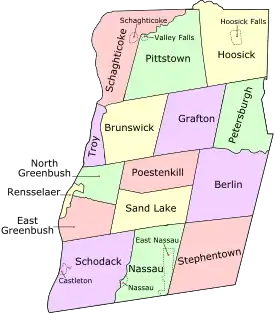
Cities
- Rensselaer
- Troy (county seat)
Towns
Census-designated places
See also
References
- "State & County QuickFacts". United States Census Bureau. Retrieved October 13, 2013.
- "Find a County". National Association of Counties. Retrieved 2011-06-07.
- "Freedoms, as Given by the Council of the Nineteen of the Chartered West India Company to All those who Want to Establish a Colony in New Netherland". World Digital Library. 1630. Retrieved 2013-07-28.
- The Kingdom of England existed until the Acts of Union 1707, when Scotland and England (including Wales) came together to form the Kingdom of Great Britain.
- "Rensselaer County History". Rensselaer County Historical Society. Retrieved July 3, 2018.
- (N.Y. Laws 1791, 14th sess., ch. 4/p. 201).
- "2010 Census Gazetteer Files". United States Census Bureau. August 22, 2012. Archived from the original on May 19, 2014. Retrieved January 7, 2015.
- "Population and Housing Unit Estimates". Retrieved May 21, 2020.
- "U.S. Decennial Census". United States Census Bureau. Retrieved January 7, 2015.
- "Historical Census Browser". University of Virginia Library. Retrieved January 7, 2015.
- "Population of Counties by Decennial Census: 1900 to 1990". United States Census Bureau. Retrieved January 7, 2015.
- "Census 2000 PHC-T-4. Ranking Tables for Counties: 1990 and 2000" (PDF). United States Census Bureau. Retrieved January 7, 2015.
- "U.S. Census website". United States Census Bureau. Retrieved 2008-01-31.
- Leip, David. "Dave Leip's Atlas of U.S. Presidential Elections". uselectionatlas.org.
- Albany Politics blog – Capital Region – Rensselaer – Saratoga – Schenectady – Albany County – NY – timesunion.com – Local politics » New legislator seated
- Rensselaer County School Districts. Archived 2009-02-07 at the Wayback Machine Capital District Regional Planning Commission. Retrieved 14 October 2008.
- Questar III Component School Districts. Archived 2010-07-07 at the Wayback Machine Questar III. Retrieved 14 October 2008.
- Washington-Saratoga-Warren-Hamilton-Essex BOCES Component Districts. Washington-Saratoga-Warren-Hamilton-Essex BOCES. Retrieved 14 October 2008.
- "Doane Stuart School Profile - Rensselaer, New York (NY)". www.privateschoolreview.com.
Further reading
- Anderson, George Baker (1897). Landmarks of Rensselaer County New York. Syracuse, New York: D. Mason and Company. OCLC 1728151.(Full text via the Internet Archive.)
- Hayner, Rutherford (1925). Troy and Rensselaer County New York: A History. New York: Lewis Historical Publishing Company, Inc. OCLC 22524006.
- Sylvester, Nathaniel Bartlett (1880). History of Rensselaer Co., New York with Illustrations and Biographical Sketches of its Prominent Men and Pioneers. Philadelphia: Everts & Peck. OCLC 3496287.
- Weise, Arthur James (1880). History of the Seventeen Towns of Rensselaer County from the Colonization of the Manor of Rensselaerwyck to the Present Time. Troy, New York: J. M. Francis & Tucker. OCLC 6637788.(Full text via the Internet Archive.)
External links
| Wikimedia Commons has media related to Rensselaer County, New York. |
- Rensselaer County homepage
- Rensselaer County at Curlie
- Hudson Valley Directory, listings pertaining to Rensselaer County, New York
- Rensselaer County Sheriff's Department
Places adjacent to Rensselaer County, New York | ||||||||||
|---|---|---|---|---|---|---|---|---|---|---|
| ||||||||||
Municipalities and communities of Rensselaer County, New York, United States | ||
|---|---|---|
| Cities | | |
| Towns | ||
| Villages | ||
| CDPs | ||
| Other hamlets | ||
| ||
| |||||||||
| |||||||||
Albany (capital) | ||
| Topics |
|  |
| Politics | ||
| Regions |
| |
| Metro areas | ||
| Counties |
| |
| Places | ||
| Authority control |
|---|