Erie County, New York
Erie County is a highly populated county located along the shore of Lake Erie in western New York State. As of the 2010 census, the population was 919,040.[1] The county seat is Buffalo, which makes up about 28% of the county's population.[2] The county's name comes from Lake Erie, which was named by European colonists for the regional Iroquoian language-speaking Erie tribe of Native Americans, who lived in the area before 1654. They were later pushed out by the more powerful Iroquoian nations tribes.
Erie County | |
|---|---|
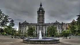
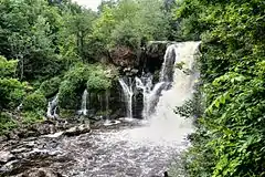
Left to right from top: Erie County Hall, Wendt Beach Park, Akron Falls Park, Chestnut Ridge Park, Canisius College, Gateway Park, Buffalo and Erie County Botanical Gardens | |
 Seal | |
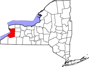 Location within the U.S. state of New York | |
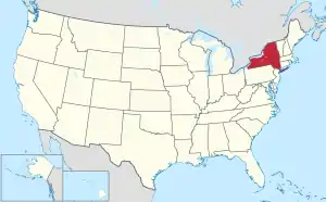 New York's location within the U.S. | |
| Coordinates: 42°45′N 78°47′W | |
| Country | |
| State | |
| Founded | 1821 |
| Named for | Eriechronon |
| Seat | Buffalo |
| Largest city | Buffalo |
| Government | |
| • County Executive | Mark Poloncarz (D) |
| Area | |
| • Total | 1,227 sq mi (3,180 km2) |
| • Land | 1,043 sq mi (2,700 km2) |
| • Water | 184 sq mi (480 km2) 15% |
| Population | |
| • Estimate (2019) | 918,702 |
| • Density | 881/sq mi (340/km2) |
| Time zone | UTC−5 (Eastern) |
| • Summer (DST) | UTC−4 (EDT) |
| Congressional districts | 26th, 27th |
| Website | www |


Erie County, along with its northern neighbor Niagara County, makes up the Buffalo-Niagara Falls metropolitan area, the second largest in New York State behind New York City. The county's southern part is known as the Southtowns.[3]
History
When counties were established by the English colonial government in the Province of New York in 1683, present-day Erie County was part of Indian territory occupied by Iroquoian-speaking peoples. It was administered as part of New York colony. Significant European-American settlement did not begin until after the United States had gained independence with the end of the American Revolutionary War in 1783. They forced the Iroquois to cede most of their lands, as many had been allies of the British.
About 1800, the Holland Land Company, formed by Americans and Dutch associates, extinguished Indian claims by purchasing the land from New York, acquired the title to the territory of what are today the eight westernmost counties of New York, surveyed their holdings, established towns and began selling lots to individuals. The state was eager to attract settlers and have farms and businesses developed. At this time, all of western New York was included in Ontario County.
As the population increased, the state legislature created Genesee County in 1802 out of part of Ontario County. In 1808, Niagara County was created out of Genesee County. In 1821, Erie County was created out of Niagara County, encompassing all the land between Tonawanda Creek and Cattaraugus Creek.[4] The first towns formed in present-day Erie County were the Town of Clarence and the Town of Willink. Clarence and Willink comprised the northern and southern portions of Erie county, respectively. Clarence is still a distinct town, but Willink was quickly subdivided into other towns. When Erie County was established in 1821, it consisted of the towns of Amherst, Aurora, Boston, Clarence, Collins, Concord, Eden, Evans, Hamburg, Holland, Sardinia and Wales.
The county has a number of houses and other properties listed on the National Register of Historic Places listings in Erie County, New York.[5]
In 1861, the hamlet of Town Line in the Town of Lancaster voted 85–40 to secede from the Union.[6] Town Line never sought admission into the Confederate States of America and there is no evidence that men from the community ever fought for the Confederacy. Some reporting from that time indicates the vote was a joke. On January 24, 1946, as part of a nationally reported event, Town Line voted to officially return to the Union after 85 years of Union secession.[7]
Geography
According to the U.S. Census Bureau, the county has a total area of 1,227 square miles (3,180 km2), of which 1,043 square miles (2,700 km2) (85%) is land and 184 square miles (480 km2) (15%) is water.[8]
Erie County is in the western portion of upstate New York, bordering on the lake of the same name. Part of the industrial area that has included Buffalo, it is the most populous county in upstate New York outside of the New York City metropolitan area. The county also lies on the international border between the United States and Canada, bordering the Province of Ontario.
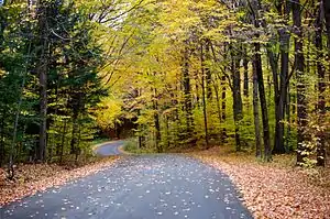
The northern border of the county is Tonawanda Creek. Part of the southern border is Cattaraugus Creek. Other major streams include Buffalo Creek (Buffalo River), Cayuga Creek, Cazenovia Creek, Scajaquada Creek, Eighteen Mile Creek and Ellicott Creek. The county's northern half, including Buffalo and its suburbs, is known as the Northtowns and is relatively flat and rises gently up from the lake. The southern half, known as the Southtowns,[3] is much hillier. It has the northwesternmost foothills of the Appalachian Mountains. The highest elevation in the county is a hill in the Town of Sardinia that tops out at around 1,940 feet (591 m) above sea level. The lowest ground is about 560 feet (171 m), on Grand Island at the Niagara River. The Onondaga Escarpment runs through the northern part of Erie County.
Rivers, streams and lakes
Adjacent counties and municipality
- Niagara County - north
- Genesee County - northeast
- Wyoming County - southeast
- Cattaraugus County - south
- Chautauqua County - southwest
- Niagara Region, Ontario, Canada - northwest
Major highways
 Interstate 90 (New York State Thruway)
.svg.png.webp) Interstate 190 (Niagara Thruway)
Interstate 190 (Niagara Thruway).svg.png.webp) Interstate 290 (Youngmann Expressway)
Interstate 290 (Youngmann Expressway).svg.png.webp) Interstate 990 (Lockport Expressway)
Interstate 990 (Lockport Expressway) U.S. Route 20 (Southwestern Boulevard/Transit Road/Broadway)
.svg.png.webp) U.S. Route 20A (Big Tree Road)
U.S. Route 20A (Big Tree Road) U.S. Route 62 (South Park Avenue/Bailey Avenue/Niagara Falls Boulevard)
 U.S. Route 219 (Southern Expressway)
 New York State Route 5 (Hamburg Turnpike/Buffalo Skyway/Main Street)
 New York State Route 16 (Seneca Street)
 New York State Route 33 (Kensington Expressway/Genesee Street)
 New York State Route 39
 New York State Route 78 (Transit Road)
 New York State Route 179 (Milestrip Expressway/Road)
 New York State Route 198 (Scajaquada Expressway)
 New York State Route 263 (Grover Cleveland Highway/Millersport Highway)
 New York State Route 240 (Orchard Park Road/Harlem Road)
 New York State Route 277 (Union Road)
 New York State Route 324 (Grand Island Boulevard/Sheridan Drive)
 New York State Route 354 (Clinton Street)
 New York State Route 400 (Aurora Expressway)
Erie County routes
National protected area
State protected areas
- Amherst State Park, Town of Amherst.
- Beaver Island State Park, Town of Grand Island.
- Buckhorn Island State Park, Town of Grand Island.
- Buffalo Harbor State Park, City of Buffalo.
- Evangola State Park, Towns of Brant and Evans.
- Great Baehre Swamp Wildlife Management Area, Town of Amherst.
- Hampton Brook Woods Wildlife Management Area, Village of Hamburg.
- Knox Farm State Park, Town of East Aurora.
- Motor Island Wildlife Management Area, Town of Grand Island.
- Onondaga Escarpment Unique Area, Town of Akron.
- Reinstein Woods Nature Preserve, Town of Cheektowaga.
- Spicer Creek Wildlife Management Area, Town of Grand Island.
- Strawberry Island State Park, Town of Townawanda.
- Tillman Road Wildlife Management Area, Town of Clarence.
- Woodlawn Beach State Park, Town of Hamburg.
- Zoar Valley Multiple Use Area, Town of Collins.
Demographics
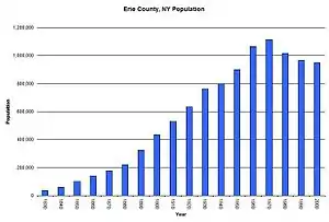
| Historical population | |||
|---|---|---|---|
| Census | Pop. | %± | |
| 1830 | 35,719 | — | |
| 1840 | 62,465 | 74.9% | |
| 1850 | 100,993 | 61.7% | |
| 1860 | 141,971 | 40.6% | |
| 1870 | 178,699 | 25.9% | |
| 1880 | 219,884 | 23.0% | |
| 1890 | 322,981 | 46.9% | |
| 1900 | 433,686 | 34.3% | |
| 1910 | 528,985 | 22.0% | |
| 1920 | 634,688 | 20.0% | |
| 1930 | 762,408 | 20.1% | |
| 1940 | 798,377 | 4.7% | |
| 1950 | 899,238 | 12.6% | |
| 1960 | 1,064,688 | 18.4% | |
| 1970 | 1,113,491 | 4.6% | |
| 1980 | 1,015,472 | −8.8% | |
| 1990 | 968,532 | −4.6% | |
| 2000 | 950,265 | −1.9% | |
| 2010 | 919,040 | −3.3% | |
| 2019 (est.) | 918,702 | [9] | 0.0% |
| U.S. Decennial Census[10] 1790-1960[11] 1900-1990[12] 1990-2000[13] 2010-2014[1] | |||
As of the 2010 census,[14] there were 919,040 people living in the county. The population density was 910 people per square mile (351/km2). There were 415,868 housing units at an average density of 398 per square mile (154/km2). The racial makeup of the county was 82.18% White, 13% Black or African American, 0.61% Native American, 1.46% Asian, 0.02% Pacific Islander, 1.42% from other races and 1.31% from two or more races. 3.27% of the population were Hispanic or Latino of any race. 19.6% were of German, 17.2% Polish, 14.9% Italian, 11.7% Irish and 5.0% English ancestry according to Census 2000. 91.1% spoke English, 3% Spanish and 1.6% Polish as their first language.
There were 380,873 households, out of which 29.6% had children under the age of 18 living with them, 46.5% were married couples living together, 13.7% had a female householder with no husband present and 36.1% were non-families. 30.5% of all households were made up of individuals and 12.5% had someone living alone who was 65 years of age or older. The average household size was 2.41 and the average family size was 3.04. In the county, the population was spread out, with 24.3% under 18, 8.7% from 18 to 24, 28.4% from 25 to 44, 22.7% from 45 to 64 and 15.9% older than 65. The median age was 38 years. For every 100 females, there were 91.6 males. For every 100 females age 18 and over, there were 87.8 males.
The median income for a household in the county was $38,567 and the median income for a family was $49,490. Males had a median income of $38,703 versus $26,510 for females. The per capita income for the county was $20,357. About 9.2% of families and 12.2% of the population were below the poverty line, including 17.3% of those under 18 and 7.8% of those older than 65.
County government and politics
Plans to merge Erie County with the City of Buffalo have been suggested, which proponents say would eliminate much of the extensive bureaucracy and political and municipal subdivisions among the various towns, cities and villages in the county. The result would be a consolidated city-county controlled by a single government, effectively making Buffalo's borders and population contiguous with that of Erie County's. These plans have proven controversial; there is controversy on the impact of the city's debt on a regional government. Concerns have also been raised that a regional government would dilute minority representation in government.[16]
Prior to 1936, Erie County predominantly backed Republican Party candidates, with only two Democratic Party candidates winning the county in a presidential election-- Grover Cleveland in 1892 and Woodrow Wilson in 1912. However, starting with the 1936 election, it has turned predominantly Democratic since then, with only two Republicans carrying the county in a presidential election-- Dwight D. Eisenhower in 1952 and 1956 and Richard Nixon in 1972, with Nixon being the most recent. However, like in most counties in the Rust Belt, Donald Trump fared better than other recent Republican presidential candidates, holding Hillary Clinton to a single-digit margin of victory in the county (50.9%-44.5%), the first Republican not to lose the county by double digits since Ronald Reagan held Walter Mondale to a 51.5%-48.3% margin of victory in 1984, yet still won the state. Joe Biden managed to return to historical norms and beat the incumbent president by a double digit 56.3%-41.6% margin in the 2020 election.
| Year | Republican | Democratic | Third parties |
|---|---|---|---|
| 2020 | 41.6% 197,527 | 56.3% 267,174 | 2.0% 9,731 |
| 2016 | 44.5% 188,303 | 50.9% 215,456 | 4.7% 19,866 |
| 2012 | 41.0% 169,675 | 57.3% 237,356 | 1.7% 7,164 |
| 2008 | 40.5% 178,815 | 58.0% 256,299 | 1.6% 6,871 |
| 2004 | 41.4% 184,423 | 56.4% 251,090 | 2.2% 9,625 |
| 2000 | 37.7% 160,176 | 56.6% 240,176 | 5.7% 24,302 |
| 1996 | 32.3% 132,343 | 54.7% 224,554 | 13.0% 53,337 |
| 1992 | 28.7% 129,444 | 43.5% 196,233 | 27.9% 125,819 |
| 1988 | 43.8% 188,796 | 55.4% 238,779 | 0.8% 3,217 |
| 1984 | 48.3% 222,882 | 51.5% 237,631 | 0.3% 1,158 |
| 1980 | 40.2% 169,209 | 51.2% 215,283 | 8.6% 35,981 |
| 1976 | 48.7% 220,310 | 50.7% 229,397 | 0.7% 3,136 |
| 1972 | 53.9% 256,462 | 45.8% 218,105 | 0.3% 1,456 |
| 1968 | 37.0% 167,853 | 55.2% 250,054 | 7.8% 35,258 |
| 1964 | 26.7% 125,962 | 73.1% 344,910 | 0.2% 704 |
| 1960 | 43.3% 211,957 | 56.6% 277,203 | 0.1% 404 |
| 1956 | 63.7% 292,657 | 36.3% 166,930 | 0.0% 0 |
| 1952 | 56.3% 253,927 | 43.6% 196,378 | 0.1% 550 |
| 1948 | 45.7% 175,118 | 51.6% 197,618 | 2.8% 10,636 |
| 1944 | 48.5% 185,975 | 51.1% 195,905 | 0.4% 1,355 |
| 1940 | 49.1% 183,664 | 50.7% 189,779 | 0.3% 992 |
| 1936 | 44.5% 152,312 | 53.6% 183,555 | 1.9% 6,341 |
| 1932 | 49.9% 141,059 | 46.3% 131,012 | 3.8% 10,859 |
| 1928 | 51.4% 144,726 | 44.9% 126,449 | 3.8% 10,614 |
| 1924 | 58.5% 112,070 | 21.3% 40,780 | 20.2% 38,630 |
| 1920 | 63.2% 99,762 | 25.6% 40,436 | 11.2% 17,598 |
| 1916 | 52.4% 53,638 | 44.5% 45,622 | 3.1% 3,200 |
| 1912 | 22.5% 19,185 | 39.4% 33,518 | 38.1% 32,410 |
| 1908 | 52.4% 52,182 | 45.3% 45,185 | 2.3% 2,293 |
| 1904 | 55.7% 49,669 | 41.0% 36,582 | 3.2% 2,881 |
| 1900 | 51.7% 44,767 | 46.0% 39,833 | 2.4% 2,057 |
| 1896 | 58.6% 45,612 | 38.7% 30,172 | 2.7% 2,095 |
| 1892 | 47.3% 32,340 | 47.4% 32,431 | 5.3% 3,632 |
| 1888 | 51.1% 31,612 | 47.7% 29,543 | 1.2% 762 |
| 1884 | 50.5% 26,249 | 47.6% 24,759 | 1.9% 985 |
Erie County executives
| Name | Party | Term |
|---|---|---|
| Edward C. Rath | Republican | 1962-1969 |
| B. John Tutuska | Republican | 1969-1971 |
| Edward Regan | Republican | 1972-1978 |
| Ed Rutkowski | Republican | 1979-1987 |
| Dennis Gorski | Democratic | 1988-1999 |
| Joel Giambra | Republican | 2000-2007 |
| Chris Collins | Republican | 2008-2011 |
| Mark Poloncarz | Democratic | 2012–present |
Elected officials
| Office | Name | Party | Hometown |
|---|---|---|---|
| County Executive | Mark Poloncarz | Democratic | Buffalo |
| County Comptroller | Stefan I. Mychajliw | Republican | Hamburg |
| County Clerk | Mickey Kearns | Democratic Republican (electorally)[18] |
Buffalo |
| District Attorney | John J. Flynn | Democratic | Buffalo |
| County Sheriff | Tim Howard | Republican | Wales |
County legislature
| District | Title | Name | Party | Hometown |
|---|---|---|---|---|
| 1 | Howard Johnson | Democratic | Buffalo | |
| 2 | Chair | April N.M. Baskin | Democratic | Buffalo |
| 3 | Lisa M. Chimera | Democratic | Kenmore | |
| 4 | Kevin Hardwick | Democratic | Tonawanda | |
| 5 | Jeanne Vinal | Democratic | Amherst | |
| 6 | Edward Rath III | Republican | Williamsville | |
| 7 | Majority Leader | Timothy J. Meyers | Democratic | Cheektowaga |
| 8 | Frank Todaro | Republican | Cheektowaga and Lancaster | |
| 9 | John Gilmour | Democratic | Hamburg | |
| 10 | Minority Leader | Joseph C. Lorigo | Conservative | West Seneca |
| 11 | John J. Mills | Republican | Orchard Park |
Education
School districts
- Akron Central School District
- Alden Central School District
- Amherst Central School District
- Buffalo City School District
- Cheektowaga Central School District
- Cheektowaga-Maryvale Union Free School District
- Cheektowaga-Sloan Union Free School District
- Clarence Central School District
- Cleveland Hill Union Free School District
- Depew Union Free School District
- East Aurora Union Free School District
- Eden Central School District
- Frontier Central School District
- Grand Island Central School District
- Gowanda Central School District
- Hamburg Central School District
- Holland Central School District
- Hopevale Union Free School District At Hamburg
- Iroquois Central School District
- Kenmore-Tonawanda Union Free School District
- Lackawanna City School District
- Lake Shore Central School District
- Lancaster Central School District
- North Collins Central School District
- Orchard Park Central School District
- Springville-Griffith Institute Central School District
- Sweet Home Central School District
- Tonawanda City School District
- West Seneca Central School District
- Williamsville Central School District
Higher education
Attractions and recreation
Erie County is home to three professional teams—the NFL's Buffalo Bills, the NHL's Buffalo Sabres and the NLL's Buffalo Bandits, along with Division I's Buffalo Bulls and MILB's Buffalo Bisons. The city of Buffalo also features the Buffalo Zoo, Buffalo and Erie County Historical Society, Burchfield-Penney Art Center and Albright-Knox Art Gallery (all located within a mile of each other in the Delaware Park System), Buffalo and Erie County Botanical Gardens and Buffalo Museum of Science, in addition to tourist districts such as Canalside and Larkinville. The Erie County Fair, held every August in the Town of Hamburg from 1820 to 2019 (the 2020 event, like much everything else across the country, was cancelled due to the COVID-19 pandemic), is one of the largest county fairs in the United States.[19]
Erie County Department of Parks, Recreation and Forestry
The Erie County Department of Parks, Recreation and Forestry was established in 1925 with four parks spanning 2,280 acres (9.2 km2). As of 2003, the county managed 38 properties, totaling approximately 11,000 acres (45 km2) of land. Management objectives include providing and maintaining recreational space and the conservation of the county's natural and historic resources.[20] A 2003 Master Plan identified several broad categories of parks operated by the county, including heritage parks, waterfront parks, conservation parks, special purpose parks and forest management areas.[20]
Heritage parks
Erie County's heritage parks include the five original county parks that were established during the 1920s and 1930s. These parks are examples of multiple-use sites with significant scenic, natural and historic features. Each park has unique man-made structures of historical character, many constructed as part of the Works Progress Administration movement in the 1930s.[21]
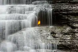
- Akron Falls Park (Established in 1933, acquired by Erie County in 1947)
- Chestnut Ridge Park (Established by Erie County in 1926)
- Como Lake Park (Established in 1923, acquired by Erie County in 1926)
- Ellicott Creek Park (Established by Erie County in 1926)
- Emery Park (Established by Erie County in 1925)
Waterfront parks
Waterfront parks include the significant scenic sites and recreational trail systems along the county's Lake Erie shoreline.[21]
- Bennett Beach Park
- Isle View Park
- Riverwalk Park
- Wendt Beach Park
Conservation parks

These largely-undeveloped parks are managed primarily for conservation of the natural environment and passive nature-based outdoor recreation activities. These lands are intended to generally remain in a natural state.[21]
- Boston Forest
- Eighteen Mile Creek Park
- Franklin Gulf Park
- Sgt. Mark A. Rademacher Memorial Park (commonly known as Hunters Creek Park)
- Scoby Dam Park
Special purpose parks
Special purpose parks have unique characteristics that provide specific recreational functions within the county's park system.[21]
- Buffalo and Erie County Botanical Gardens
- Elma Meadows Golf Course
- Grover Cleveland Golf Course
- Sprague Brook Park
Forest management areas
Forest management areas are managed by the Erie County Bureau of Forestry, which was established in 1927. These areas include several thousand acres of mostly-coniferous plantation style forest, much of which was planted on abandoned farmland by the Civilian Conservation Corps in the 1930s. These areas are located mostly in the rural southern portion of the county.[22] These lands have limited recreation potential, mostly in the form of trails. Management of these lands is focused on natural resource conservation, in addition to potential commercial resource extraction of timber products or maple syrup.[21][22]
Communities
Cities
- Buffalo (county seat)
- Lackawanna
- Tonawanda
Towns
Villages
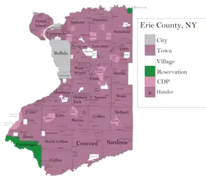
Census-designated places
Hamlets
- Akron Junction
- Alden Center
- Armor
- Athol Springs
- Bagdad
- Bellevue
- Big Tree
- Blakeley
- Blossom
- Boston
- Bowmansville
- Brant
- Brighton
- Carnegie
- Chaffee
- Clarksburg
- Cleveland Hill
- Clifton Heights
- Collins Center
- Concord
- Creekside
- Crittenden
- Dellwood
- Derby
- Doyle
- Duells Corner
- Dutchtown
- East Amherst
- East Concord
- East Eden
- East Elma
- East Seneca
- Ebenezer
- Eden Valley
- Ellicott
- Elma
- Evans Center
- Ferry Village
- Footes
- Forks
- Fowlerville
- Gardenville
- Getzville
- Glenwood
- Green Acres
- Griffins Mills
- Holland
- Hunts Corners
- Jerusalem Corners
- Jewettville
- Kenilworth
- Lake View
- Langford
- Lawtons
- Locksley Park
- Looneyville
- Loveland
- Marilla
- Marshfield
- Millersport
- Millgrove
- Morton Corners
- Mount Vernon
- Murrays Corner
- New Ebenezer
- New Oregon
- North Bailey
- North Evans
- Oakfield
- Patchin
- Peters Corners
- Pine Hill
- Pinehurst
- Pontiac
- Porterville
- Protection
- Sand Hill
- Sandy Beach
- Scranton
- Sheenwater
- Shirley
- Snyder
- South Cheektowaga
- South Newstead
- South Wales
- Spring Brook
- Swifts Mills
- Taylor Hollow
- Town Line Station
- Swormville
- Walden Cliffs
- Wales Hollow
- Water Valley
- Webster Corners
- Wende
- West Alden
- West Falls
- Weyer
- Williston
- Windom
- Wolcottsburg
- Woodlawn
- Woodside
- Wyandale
- Zoar
Indian reservations
See also
References
- "State & County QuickFacts". United States Census Bureau. Archived from the original on June 29, 2011. Retrieved October 11, 2013.
- "Find a County". National Association of Counties. Archived from the original on 2011-05-31. Retrieved 2011-06-07.
- Smyczynski, Christine A. (2005). "Southern Erie County - "The Southtowns"". Western New York: From Niagara Falls and Southern Ontario to the Western Edge of the Finger Lakes. The Countryman Press. p. 136. ISBN 0-88150-655-9.
- The Burned-Over District: Evolution of County Boundaries. Oliver Cowdery Home Page Archived 2009-01-29 at the Wayback Machine, accessed 7 December 2008.
- "National Register Information System". National Register of Historic Places. National Park Service. April 15, 2008.
- Klein, Christopher (18 October 2018). "This New York Village Seceded from the Union...for 85 Years". History (American TV channel). Archived from the original on 29 March 2020. Retrieved 29 March 2020.
- Kwiatkowski, Jane (September 7, 2011). "Secessionist hamlet takes stroll down memory lane; Hamlet of Town Line marks its unique role in the Confederacy". The Buffalo News. Archived from the original on July 30, 2012. Retrieved September 7, 2012.CS1 maint: bot: original URL status unknown (link)
- "2010 Census Gazetteer Files". United States Census Bureau. August 22, 2012. Archived from the original on May 19, 2014. Retrieved January 4, 2015.
- "Population and Housing Unit Estimates". Archived from the original on May 29, 2017. Retrieved December 20, 2019.
- "U.S. Decennial Census". United States Census Bureau. Archived from the original on April 26, 2015. Retrieved January 4, 2015.
- "Historical Census Browser". University of Virginia Library. Archived from the original on August 11, 2012. Retrieved January 4, 2015.
- "Population of Counties by Decennial Census: 1900 to 1990". United States Census Bureau. Archived from the original on February 19, 2015. Retrieved January 4, 2015.
- "Census 2000 PHC-T-4. Ranking Tables for Counties: 1990 and 2000" (PDF). United States Census Bureau. Archived (PDF) from the original on December 18, 2014. Retrieved January 4, 2015.
- "U.S. Census website". United States Census Bureau. Archived from the original on 2014-12-18. Retrieved 2008-01-31.
- "Empire State Development" (PDF). esd.ny.gov. Archived from the original on August 19, 2008.
- Hansen, Robert (July 2005). "Research Brief:County Government Structure Update (vol. 3, no. 1)". National Association of Counties. Archived from the original on 2007-10-09. Retrieved 2007-11-12.
- Leip, David. "Dave Leip's Atlas of U.S. Presidential Elections". uselectionatlas.org. Archived from the original on 2018-03-23. Retrieved 2016-11-15.
- "Michael Kearns". Ballotpedia. Archived from the original on 2018-11-07. Retrieved 2018-07-07.
- "Carnival Warehouse" (PDF). CarnivalWarehouse.com. Retrieved 22 May 2019.
- Erie County (N.Y.) Department of Parks, Recreation, & Forestry; Erie County (N.Y.) Department of Environment & Planning; Parsons; Envision: The Hough Group; Paradigm Consulting; Wendel-Duchscherer Architects & Engineers (2003). Erie County Parks System Master Plan - Executive Summary (PDF). Erie County. pp. 1–16. Archived (PDF) from the original on April 2, 2015. Retrieved March 7, 2015.CS1 maint: multiple names: authors list (link)
- Erie County (N.Y.) Department of Parks, Recreation, & Forestry; Erie County (N.Y.) Department of Environment & Planning; Parsons; Envision: The Hough Group; Paradigm Consulting; Wendel-Duchscherer Architects & Engineers (2003). Erie County Parks System Master Plan, Volume 1, Section 3 - Overall System Framework (PDF). Erie County. pp. 1–13. Archived (PDF) from the original on May 4, 2015. Retrieved March 6, 2015.CS1 maint: multiple names: authors list (link)
- "Bureau of Forestry". Erie County Department of Parks, Recreation and Forestry (Erie.gov). Archived from the original on February 21, 2015. Retrieved March 7, 2015.
- "Erie County School Districts 2003-2004". New York State Education Department. Retrieved 2007-11-12.
External links
| Wikivoyage has a travel guide for Erie County (New York). |
| Wikisource has the text of a 1920 Encyclopedia Americana article about Erie County, New York. |
- Erie County Bureau of Forestry Trails
- Erie County Government website (county overview here)
- The Buffalo and Erie County Historical Society
- Erie County Fair
- U.S. Census Bureau
- Erie County at Curlie
- The Roman Catholic Diocese of Buffalo, New York
- The Erie County Fiscal Stability Authority website a New York state public-benefit corporation
Places adjacent to Erie County, New York | |
|---|---|
| Principal city | 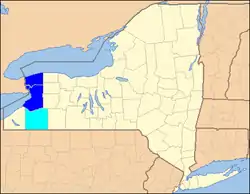 | |
|---|---|---|
| Other major cities | ||
| Counties | ||
| Authority control |
|---|