Dutchess County, New York
Dutchess County is a county in the U.S. state of New York. As of the 2010 census, the population was 297,488.[1] The county seat is the city of Poughkeepsie.[2] The county was created in 1683, one of New York's first twelve counties, and later organized in 1713.[3] It is located in the Mid-Hudson Region of the Hudson Valley, north of New York City.
Dutchess County | |
|---|---|
 Main Mall Row, Poughkeepsie | |
 Flag  Seal | |
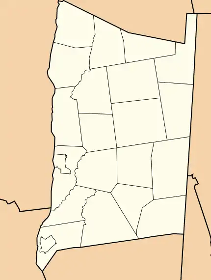
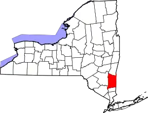 Location within the U.S. state of New York | |
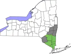
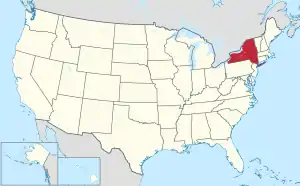 New York's location within the U.S. | |
| Coordinates: 41°46′N 73°45′W | |
| Country | |
| State | |
| Founded | 1713 |
| Named for | Mary of Modena, Duchess of York |
| Seat | Poughkeepsie |
| Largest city | Poughkeepsie |
| Government | |
| • Executive | Marcus Molinaro (R) |
| Area | |
| • Total | 825 sq mi (2,140 km2) |
| • Land | 796 sq mi (2,060 km2) |
| • Water | 30 sq mi (80 km2) |
| Population | |
| • Estimate (2019) | 294,218 |
| • Density | 374/sq mi (144/km2) |
| Time zone | UTC−5 (Eastern) |
| • Summer (DST) | UTC−4 (EDT) |
| Congressional districts | 18th, 19th |
| Website | www |
Dutchess County is part of the Poughkeepsie–Newburgh–Middletown Metropolitan Statistical Area,[4] which belongs to the larger New York–Newark–Bridgeport, NY-NJ-CT-PA Combined Statistical Area.
History
Before Anglo-Dutch settlement, what is today Dutchess County was a leading center for the native Wappinger peoples. They had their council-fire at what is now Fishkill Hook,[5] and had settlements throughout the area.
On November 1, 1683, the Province of New York established its first twelve counties, including Dutchess. Its boundaries at that time included the present Putnam County, and a small portion of the present Columbia County (the towns of Clermont and Germantown). The county was named for Mary of Modena, Duchess of York; dutchess is an archaic spelling of the word duchess.[6][7]
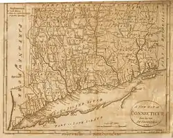
The Province of New York and the Connecticut Colony negotiated an agreement on November 28, 1683, establishing their border as 20 miles (32 km) east of the Hudson River, north to Massachusetts. The 61,660 acres (249.5 km2) east of the Byram River making up the Connecticut Panhandle were granted to Connecticut, in recognition of the wishes of the residents. In exchange, Rye was granted to New York, along with a 1.81-mile (2.91 km) wide strip of land running north from Ridgefield to Massachusetts alongside the New York counties of Westchester, Putnam then Dutchess, known as "The Oblong". The eastern half of the stub of land in northeast Dutchess County containing Rudd Pond and Taconic State Park is the northernmost extension of The Oblong.[8]
Until 1713, Dutchess was administered by Ulster County. On October 23, 1713, Queen Anne gave permission for Dutchess County to elect its own officers from among their own population, including a supervisor, tax collector, tax assessor and treasurer. In 2013, Dutchess County celebrated its 300th anniversary of democracy based upon a legislative resolution sponsored by County Legislator Michael Kelsey from Salt Point. In 1812, Putnam County was detached from Dutchess.[9]
The Patents
.png.webp)
Fourteen royal land patents were granted between 1685 and 1706 covering the entirety of the original footprint of Dutchess County (which until 1812 included today's Putnam County).
The first ten, granted between 1685 and 1697, covered almost all of Hudson River shoreline in the original county, with three - Rombouts, the Great Nine Partners, and Philipse Patents - extending significantly inland. The eleventh, and smallest, Cuyler, 1697, was the first to contain solely inland territory, just in from the Hudson. The twelfth, and next smallest, Fauconnier, in 1705, completed the Hudson River shoreline. The last two, Beekman, 1705, and the Little Nine Partners, 1706, laid claim to the remaining interior lands.
- 1685 Rombout (Beacon/Fishkill Area)
- 1686 Minnisinck (Sanders & Harmense)
- 1686 Kip
- 1688 Schuyler (Poughkeepsie)
- 1688 Schuyler (Red Hook)
- 1688 Ærtsen-Roosa-Elton
- 1696 Pawling-Staats
- 1697 Rhinebeck
- 1697 (Great) Nine Partners
- 1697 Philipse
- 1697 Cuyler
- 1705 Fauconnier
- 1705 Beekman (Back Lots)
- 1706 (Little) Nine Partners
Early settlement
From 1683 to 1715 most of the settlers in Dutchess County were Dutch. Many of these moved in from Albany and Ulster Counties. They settled along the Fishkill Creek and in the areas that are now Poughkeepsie and Rhinebeck.[10]
From 1715 to 1730 most of the new settlers in Dutchess county were Germans. From 1730 until 1775 New Englanders were the main new settlers in Dutchess County.[11]
20th century
Franklin D. Roosevelt lived in his family home in Hyde Park, overlooking the Hudson River. His family's home is now the Home of Franklin D. Roosevelt National Historic Site, managed by the National Park Service.
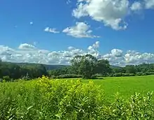
Prior to the 1960s, Dutchess County was primarily agricultural. Since then the southwestern part (from Poughkeepsie southward and from the Taconic State Parkway westward) of the county has developed into a largely residential area, suburban in character, with many of its residents commuting to jobs in New York City and Westchester County. The northern and eastern regions of the county remain rural with large farmlands but at the same time developed residences used during the summer and or on weekends by people living in the New York City urban area.[12]
Geography
According to the U.S. Census Bureau, the county has a total area of 825 square miles (2,140 km2), of which 796 square miles (2,060 km2) is land and 30 square miles (78 km2) (3.6%) is water.[13]
Dutchess County is located in southeastern New York State, between the Hudson River on its west and the New York–Connecticut border on its east, about halfway between the cities of Albany and New York City. It contains two cities: Beacon and Poughkeepsie. Depending on precise location within the county, road travel distance to New York City ranges between 58 miles (93 km) and 110 miles (180 km).
The terrain of the county is mostly hilly, especially in the Hudson Highlands in the southwestern corner and the Taconic Mountains to the northeast. Some areas nearer the river are flatter.
The highest point in the county is the summit of Brace Mountain, in the Taconics, at 2,311 feet (704 m) above sea level. The lowest point is sea level, along the Hudson River.
Almost a half mile long border exists with Berkshire County, Massachusetts in the extreme northern end of the county.
Adjacent counties
- Columbia County – north
- Berkshire County, Massachusetts – northeast
- Litchfield County, Connecticut – east
- Fairfield County, Connecticut – southeast
- Putnam County – south
- Orange County – southwest
- Ulster County – west
National protected areas
State, county, and town parks
- Bowdoin County Park
- Hudson Highlands State Park
- Stratt Town Park
- Wilcox County Park
- Tymor Forest
- Taconic State Park
- Beekman Rec
- East Fishkill Rec
- James Baird State Park
- Poughkeepsie Bridge (Walkway over the Hudson)
- Dover Stone Church
- Carnwath Farms Historic Site & Park
- Roosevelt Farm Lane
Demographics
| Historical population | |||
|---|---|---|---|
| Census | Pop. | %± | |
| 1790 | 45,276 | — | |
| 1800 | 47,775 | 5.5% | |
| 1810 | 51,363 | 7.5% | |
| 1820 | 46,615 | −9.2% | |
| 1830 | 50,926 | 9.2% | |
| 1840 | 52,398 | 2.9% | |
| 1850 | 58,992 | 12.6% | |
| 1860 | 64,941 | 10.1% | |
| 1870 | 74,041 | 14.0% | |
| 1880 | 79,184 | 6.9% | |
| 1890 | 77,879 | −1.6% | |
| 1900 | 81,670 | 4.9% | |
| 1910 | 87,661 | 7.3% | |
| 1920 | 91,747 | 4.7% | |
| 1930 | 105,462 | 14.9% | |
| 1940 | 120,542 | 14.3% | |
| 1950 | 136,781 | 13.5% | |
| 1960 | 176,008 | 28.7% | |
| 1970 | 222,295 | 26.3% | |
| 1980 | 245,055 | 10.2% | |
| 1990 | 259,462 | 5.9% | |
| 2000 | 280,150 | 8.0% | |
| 2010 | 297,488 | 6.2% | |
| 2019 (est.) | 294,218 | [14] | −1.1% |
| U.S. Decennial Census[15] 1790–1960[16] 1900–1990[17] 1990–2000[18] 2010–2019[1] | |||
As of the census[19] of 2000, there were 280,150 people, 99,536 households, and 69,177 families residing in the county. The population density was 350 people per square mile (135/km2). There were 106,103 housing units at an average density of 132 per square mile (51/km2). 22.0% of the population was of Italian, 16.9% Irish, 11.3% German and 6.7% English ancestry according to Census 2000. 88.3% spoke English and 4.8% spoke Spanish.
Based on the Census Ancestry tallies, including people who listed more than one ancestry, Italians were the largest group in Dutchess County with 60,645. Irish came in a very close second at 59,991. In third place were the 44,915 Germans who barely exceeded the 44,078 people not in the 105 specifically delineated ancestry groups.[20]
There were 99,536 households, out of which 34.5% had children under the age of 18 living with them, 55.5% were married couples living together, 10.3% had a female householder with no husband present, and 30.5% were non-families. 24.6% of all households were made up of individuals, and 9.0% had someone living alone who was 65 years of age or older. The average household size was 2.63 and the average family size was 3.16.
In the county, the age distribution of the population shows 25.1% under the age of 18, 9.4% from 18 to 24, 30.2% from 25 to 44, 23.2% from 45 to 64, and 12.0% who were 65 years of age or older. The median age was 37 years. For every 100 females, there were 100.1 males. For every 100 females age 18 and over, there were 98.2 males.
The median income for a household in the county was $53,086, and the median income for a family was $63,254. Males had a median income of $45,576 versus $30,706 for females. The per capita income for the county was $23,940. About 5.0% of families and 7.5% of the population were below the poverty line, including 8.5% of those under age 18 and 6.5% of those age 65 or over.
The decrease in population between 1810 and 1820 was due to the separation of Putnam County from Dutchess in 1812.
Racial demographics
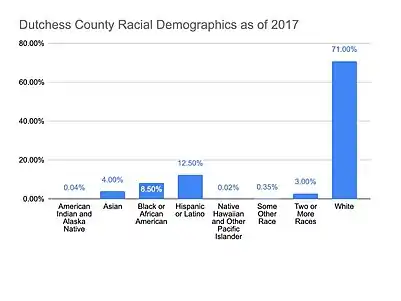
As of 2017, the residents of Dutchess County were reported as the following: American Indian and Alaska Native (0.04%), Asian (4%), Black or African American (8.5%), Hispanic or Latino (12.5%), Native Hawaiian and Other Pacific Islander (0.016%), Some Other Race (0.35%), Two or More Races (3%), White (71%).[21]
Government
Dutchess County has a Charter Government with a County Executive and directly elected legislature of 25 members, each elected from a single member district.[22] The Charter form of Government went in to effect in 1968 given the favorable outcome of a 1967 special election dedicated to the question. Since 1713, the County Government had been managed by a Board of Supervisors, made up of the locally elected leaders.[23]
| Name | Party | Term |
|---|---|---|
| David C. Schoentag | Republican | January 1, 1968 – December 31, 1971 |
| Edward C. Scheuler | Republican | January 1, 1976 – April 29, 1978 |
| James D. Benson | Republican | April 29, 1978 – December 31, 1978 |
| Lucille P. Pattison | Democrat | January 1, 1979 – December 31, 1991 |
| William R. Steinhaus | Republican | January 1, 1992 – December 31, 2011 |
| Marcus J. Molinaro | Republican | January 1, 2012 – present |
| District | Legislator | Title | Party | Residence |
|---|---|---|---|---|
| 1 | Giancarlo Llaverias | Democrat | Poughkeepsie | |
| 2 | Don Sagliano | Majority Leader | Republican | Pleasant Valley |
| 3 | Michael P. Polasek | Republican | Poughkeepsie | |
| 4 | Hannah Black | Democrat | Hyde Park | |
| 5 | Thomas L. Keith, Jr. | Republican | Poughkeepsie | |
| 6 | Rebecca Edwards | Minority Leader | Democrat | Poughkeepsie |
| 7 | Will Truitt | Republican | Hyde Park | |
| 8 | Craig P. Brendli | Democrat | Poughkeepsie | |
| 9 | Randy Johnson | Democrat | Poughkeepsie | |
| 10 | Barrington R. Atkins | Democrat | Poughkeepsie | |
| 11 | Brennan Kearney | Democrat | Rhinebeck | |
| 12 | John D. Metzger | Republican | Hopewell Junction | |
| 13 | Donna Bolner | Assistant Majority Leader | Republican | LaGrangeville |
| 14 | Francena I. Amparo | Democrat | Wappingers Falls | |
| 15 | Joseph Incoronato | Republican | Wappingers Falls | |
| 16 | Frits Zernike | Democrat | Beacon | |
| 17 | James J. Miccio | Republican | Fishkill | |
| 18 | Nick Page | Assistant Minority Leader | Democrat | Beacon |
| 19 | A. Gregg Pulver | Chairman | Republican | Pine Plains |
| 20 | Kristofer Munn | Democrat | Red Hook | |
| 21 | Marge J. Horton | Republican | Hopewell Junction | |
| 22 | Faye Garito | Republican | Poughquag | |
| 23 | John M. Thomes | Republican | Pawling | |
| 24 | Alan V. Surman | Republican | Pawling | |
| 25 | Deirdre Houston | Republican | Millbrook |
Law enforcement
The Cities of Beacon and Poughkeepsie; Towns of Fishkill, Hyde Park, Pine Plains, Poughkeepsie, Rhinebeck, Red Hook, and East Fishkill and Villages of Millerton, Wappingers Falls, Millbrook, and Fishkill have their own Police departments. The remainder of the county is patrolled by the Dutchess County Sheriff's Office and New York State Police. The New York State Police Troop K headquarters is located in Millbrook.
Elections
| Year | Republican | Democratic | Third parties |
|---|---|---|---|
| 2020 | 44.3% 66,872 | 53.9% 81,443 | 1.9% 2,807 |
| 2016 | 47.2% 61,821 | 47.5% 62,285 | 5.3% 6,912 |
| 2012 | 45.3% 56,025 | 52.8% 65,312 | 1.9% 2,368 |
| 2008 | 45.1% 59,628 | 53.7% 71,060 | 1.2% 1,614 |
| 2004 | 51.2% 63,372 | 47.0% 58,232 | 1.8% 2,277 |
| 2000 | 47.1% 52,669 | 46.9% 52,390 | 6.0% 6,712 |
| 1996 | 40.4% 41,929 | 45.6% 47,339 | 14.0% 14,553 |
| 1992 | 40.5% 46,709 | 36.1% 41,655 | 23.4% 26,964 |
| 1988 | 61.0% 62,165 | 38.2% 38,968 | 0.8% 826 |
| 1984 | 67.9% 70,324 | 31.7% 32,867 | 0.4% 389 |
| 1980 | 57.7% 53,616 | 30.8% 28,616 | 11.6% 10,775 |
| 1976 | 56.9% 51,312 | 41.7% 37,531 | 1.4% 1,268 |
| 1972 | 69.8% 64,864 | 30.0% 27,872 | 0.2% 167 |
| 1968 | 54.9% 45,032 | 37.8% 31,025 | 7.3% 6,010 |
| 1964 | 37.0% 29,503 | 62.9% 50,179 | 0.1% 43 |
| 1960 | 60.7% 46,109 | 39.3% 29,842 | 0.1% 53 |
| 1956 | 78.4% 53,840 | 21.7% 14,876 | 0.0% 0 |
| 1952 | 71.2% 46,381 | 28.6% 18,644 | 0.2% 142 |
| 1948 | 64.2% 34,067 | 32.9% 17,439 | 2.9% 1,533 |
| 1944 | 58.9% 32,890 | 40.8% 22,778 | 0.3% 158 |
| 1940 | 55.7% 32,329 | 44.1% 25,598 | 0.2% 122 |
| 1936 | 53.1% 28,868 | 45.0% 24,467 | 1.9% 1,010 |
| 1932 | 55.0% 25,757 | 43.5% 20,374 | 1.6% 740 |
| 1928 | 61.3% 28,687 | 35.8% 16,748 | 2.9% 1,366 |
| 1924 | 64.6% 22,173 | 25.8% 8,864 | 9.5% 3,266 |
| 1920 | 65.6% 21,152 | 30.8% 9,938 | 3.6% 1,156 |
| 1916 | 54.6% 11,082 | 43.9% 8,906 | 1.5% 310 |
| 1912 | 43.7% 8,916 | 43.4% 8,871 | 12.9% 2,638 |
| 1908 | 53.6% 11,132 | 43.1% 8,961 | 3.3% 682 |
| 1904 | 57.1% 11,709 | 40.3% 8,275 | 2.6% 537 |
| 1900 | 59.4% 11,936 | 38.3% 7,691 | 2.3% 471 |
| 1896 | 62.4% 12,127 | 34.2% 6,634 | 3.4% 661 |
| 1892 | 48.1% 9,376 | 46.1% 8,978 | 5.9% 1,141 |
| 1888 | 51.0% 10,265 | 45.9% 9,249 | 3.2% 634 |
| 1884 | 51.1% 9,701 | 45.7% 8,677 | 3.1% 596 |
Historically, Dutchess County was a classic "Yankee Republican" county. Its Republican bent was due to its affluence and large suburban swaths. Between 1884 and 2004, the Republican presidential candidate carried Dutchess County in 28 out of 30 elections. The only times this tradition was broken came in 1964 and 1996. As a measure of how Republican the county was, Hyde Park resident Franklin Roosevelt was completely shut out in the county during his four successful bids for president.
The Republican edge narrowed significantly in the 1990s, with George H. W. Bush going from 61 percent of the county's vote in 1988 to only 40.5 percent in 1992. In 2008, Barack Obama became only the third Democrat to carry the county since 1884, and the first to win a majority since Lyndon Johnson in 1964. It has gone for the Democratic candidate in four consecutive elections (2008, 2012, 2016, and 2020).
In recent years, Dutchess County has become a powerful swing county at the national level, with both parties winning at least forty percent of the vote in every election since 1996.
Dutchess County is split between two congressional districts. The more populated southern portion is in the 18th district, represented by Democrat Sean Patrick Maloney The northern portion is in the 19th district, represented by Democrat Antonio Delgado. These are considered "swing" districts nationally, with Cook Partisan Voting Index ratings of R+1 and R+2, respectively, as of 2019.
The current composition of the County Legislature is 14 Republicans and 11 Democrats.
Transportation
Highways
- Interstate 84 traverses the county in an east–west route cutting through the southern quadrant of the county. It is the only interstate highway in the county.
- US 9, the Taconic State Parkway, and NY 22 are the main north–south roads in the county.
- US 44, NY 55, and NY 199 are the other main east–west roads in the county
Railroads
Amtrak has stations in Rhinecliff, a small hamlet in the Town of Rhinebeck, and Poughkeepsie, with both stations being served by Empire Service trains as well as other trains that run along the line. The latter station is the terminus of the Hudson Line of the Metro-North Railroad. The Hudson Line also has station stops in New Hamburg (a hamlet of the town of Poughkeepsie) and Beacon.
The Harlem Line, on the eastern side of the county, has station stops in Pawling, Wingdale, Dover Plains, and two stops in Wassaic (one along the Tenmile River and the other the namesake terminus of that line).
Buses
Public transportation in Dutchess County is handled by Dutchess County Public Transit. Outside of the urbanized area of the county, most service is limited. Privately run lines connect Poughkeepsie to New Paltz and Beacon to Newburgh.
For intercity bus service, Leprechaun Lines and Short Line Bus also operate some service through Poughkeepsie, Rhinebeck, and the southern part of the county. The last time service ran outside that area was in the late-1990s when Peter Pan/Bonanza ran service to New York City in the eastern part of the county.
Air
The Hudson Valley Regional Airport, located in the town of Wappinger, is a general aviation facility that once had commercial service. The closest commercial airport, New York Stewart International Airport, is located across the Hudson River in Newburgh.
Also located in the county is Sky Park Airport, a public-use general aviation facility in Red Hook, New York.[25]
Culture
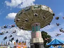
Dutchess County holds an annual county fair. The County Chamber of Commerce holds an annual hot air balloon launch typically in the first week of July. The main launch sites are along the Hudson River. As many as 20 balloons participate in the event.
The Dutchess County Historical Society was formed in 1914 and is active in the preservation of a large collection at the 18th century Clinton House. The Society has published a yearbook since 1914 and presents up to four awards of merit in the field of Dutchess County history each year.
Media
Dutchess County has no television stations. Its only news radio format station is WKIP (AM) of Poughkeepsie. WRHV is an NPR affiliated broadcasting out of Poughkeepsie. The country music format station, WRWB-FM, broadcasting across the Hudson River, can be reached in much of the county.
Poughkeepsie Journal is published in that city. Vassar Miscellany News, associated with Vassar College, is published weekly. Also published in the county is the Beacon Free Press/Southern Dutchess News.
Sports
The Hudson Valley Renegades are a minor league baseball team affiliated with the Tampa Bay Rays. The team is a member of the New York–Penn League, and play at Dutchess Stadium in Fishkill.
The Hudson Valley Bears were one of four founding members of the Eastern Professional Hockey League (EPHL). They played their home games at the Mid-Hudson Civic Center in Poughkeepsie.
The Hudson Valley Hawks was a team in the former National Professional Basketball League. The team's home court was at Beacon High School, in Beacon.
Health
In March 2020, the COVID-19 pandemic was first discovered in the county. As of December 19, 2020 there are a total of 9,959 cases, 210 deaths and 8,333 recoveries.[26]
Communities
N.B.: Cities, Towns and Villages are official political designations.
Cities
- Beacon
- Poughkeepsie (county seat)
Towns
Census-designated places
- Amenia
- Arlington
- Bard College
- Barrytown
- Brinckerhoff
- Chelsea Cove
- Crown Heights
- Dover Plains
- Fairview
- Freedom Plains
- Haviland
- Hillside Lake
- Hopewell Junction
- Hyde Park
- MacDonnell Heights
- Marist College
- Merritt Park
- Myers Corner
- New Hackensack
- New Hamburg
- Pine Plains
- Pleasant Valley
- Red Oaks Mill
- Rhinecliff
- Salt Point
- Shorehaven
- Spackenkill
- Staatsburg
- Titusville
- Upper Red Hook
- Vassar College
- Wassaic
- Wingdale
Hamlets
- Annandale-on-Hudson
- Arthursburg
- Attlebury
- Bangall
- Barnegat
- Castle Point
- De Witt Mills
- Fishkill Plains
- Glenham
- Gretna
- Holmes
- Hopewell Junction
- Hortontown
- Hughsonville
- Johnsontown
- Knapps Corner
- Lomala
- Mabbettsville
- McIntyre
- Millbrook
- Norrie Heights
- Pecksville
- Pleasant Plains
- Poughquag
- Rudco
- Shenandoah
- Shekomeko
- Stanfordville
- Stissing
- Stormville
- Swartwoutville[27]
- Van Keurens
- Verbank
- Washington Hollow
- Wiccopee
- Willow Brook
Education
Public school districts
- Arlington Central School District
- Beacon City School District
- Dover Union Free School District
- Hyde Park Central School District
- Millbrook Central School District
- Pawling Central School District
- Pine Plains Central School District
- Poughkeepsie City School District
- Red Hook Central School District
- Rhinebeck Central School District
- Spackenkill Union Free School District
- Wappingers Central School District
- Webutuck Central School District
- Dutchess County BOCES
Private schools
- Oakwood Friends School
- Our Lady of Lourdes High School
- Poughkeepsie Day School
- Dutchess Day School
- The Kildonan School
- Millbrook School
- Trinity-Pawling School
- Tabernacle Christian Academy
- Upton Lake Christian School
- Holy Trinity School
- Hawk Meadow Montessori School
Higher education
- Bard College (Annandale-on-Hudson)
- Culinary Institute of America main campus (Hyde Park)
- Dutchess Community College (Poughkeepsie)
- Marist College (Poughkeepsie)
- Ridley-Lowell Business & Technical Institute (Poughkeepsie)
- Vassar College (Poughkeepsie)
See also
References
- "State & County QuickFacts". United States Census Bureau. Archived from the original on June 25, 2011. Retrieved October 11, 2013.
- "Find a County". National Association of Counties. Archived from the original on July 12, 2012. Retrieved June 7, 2011.
- Hasbrouck, Frank, ed. (1909). The History of Dutchess County New York. Poughkeepsie, New York: S. A. Matthieu. Retrieved January 9, 2015.
- United States Office of Management and Budget (September 14, 2018). "OMB Bulletin No. 18-04" (PDF). Retrieved July 11, 2019.
- MacCraken, Henry Noble, Old Dutchess Forever! The Story of an American County (New York: Hastings House, 1956) p. 3
- Gannett, Henry (1905). The Origin of Certain Place Names in the United States. Govt. Print. Off. pp. 111.
- https://www.dutchessny.gov/Departments/History/A-Brief-History-of-Dutchess-County.htm
- "New York: Individual County Chronologies". New York Atlas of Historical County Boundaries. The Newberry Library. 2008. Retrieved January 9, 2015.
- Pucher, J. Wilson and Helen Wilkinson Reynolds, Old Gravestones of Dutchess County, New York (Poughkeepsie: Dutchess County Historical Society, 1924) p. xi
- Pulcher and Reynolds. Old Gravestones. p. xi
- Hobson, Archie, ed., The Cambridge Gazetteer of the United States and Canada (New York: Cambridge University Press, 1995) pp. 183–184
- "2010 Census Gazetteer Files". United States Census Bureau. August 22, 2012. Archived from the original on May 19, 2014. Retrieved January 4, 2015.
- "Population and Housing Unit Estimates". Retrieved March 26, 2020.
- "U.S. Decennial Census". United States Census Bureau. Retrieved January 4, 2015.
- "Historical Census Browser". University of Virginia Library. Retrieved January 4, 2015.
- "Population of Counties by Decennial Census: 1900 to 1990". United States Census Bureau. Retrieved January 4, 2015.
- "Census 2000 PHC-T-4. Ranking Tables for Counties: 1990 and 2000" (PDF). United States Census Bureau. Retrieved January 4, 2015.
- "U.S. Census website". United States Census Bureau. Retrieved January 31, 2008.
- U.S. Census website chart on Ancesties for Dutchess County, New York
- "Dutchess County, NY | Data USA". datausa.io. Retrieved November 15, 2019.
- "Residents Vote For Major Change". Poughkeepsie Journal. Poughkeepsie, NY. April 18, 1967.
- William P. Tatum III, Ph.D., County Historian (June 2017). "Dutchess County Government History Exhibit". Dutchess County Government.CS1 maint: multiple names: authors list (link)
- Leip, David. "Dave Leip's Atlas of U.S. Presidential Elections". uselectionatlas.org. Retrieved October 22, 2018.
- FAA Airport Form 5010 for 46N PDF. Federal Aviation Administration. Effective April 10, 2008.
- "ArcGIS Dashboards". dcny.maps.arcgis.com. Retrieved December 20, 2020.
- Swartwoutville
Further reading
- MacCracken, Henry Noble. Old Dutchess Forever!, New York: Hastings House, ©1956. LC 56-12863
- Smith, James H. History of Dutchess County, New York, Syracuse, New York: 1882. Reprinted: Interlaken, New York: Heart of the Lakes Publishing. ISBN 0-932334-35-0
External links
| Wikimedia Commons has media related to Dutchess County, New York. |
| Wikivoyage has a travel guide for Dutchess County. |
Places adjacent to Dutchess County, New York | |
|---|---|
| |||||||||
| |||||||||
Municipalities and communities of Dutchess County, New York, United States | ||
|---|---|---|
| Cities | | |
| Towns | ||
| Villages | ||
| CDPs |
| |
| Other hamlets | ||
| Former communities | ||
| Footnotes | ‡This populated place also has portions in an adjacent county or counties | |
| ||
| Authority control |
|---|
