National Register of Historic Places listings in Apache County, Arizona
This is a list of the National Register of Historic Places listings in Apache County, Arizona. It is intended to be a complete list of the properties and districts on the National Register of Historic Places in Apache County, Arizona, United States. The locations of National Register properties and districts for which the latitude and longitude coordinates are included below, may be seen in a map.[1]

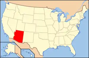
Location of Apache County in Arizona
There are 32 properties and districts listed on the National Register in the county, including 6 that are also National Historic Landmarks.
- This National Park Service list is complete through NPS recent listings posted January 29, 2021.[2]
Listings county-wide
| [3] | Name on the Register | Image | Date listed[4] | Location | City or town | Description |
|---|---|---|---|---|---|---|
| 1 | Allentown Bridge | 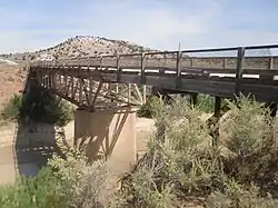 Allentown Bridge |
September 30, 1988 (#88001617) |
Indian Route 9402 over the Puerco River at milepost 9.1 35°16′51″N 109°09′16″W |
Houck | |
| 2 | Alpine Elementary School |  Alpine Elementary School |
April 25, 1997 (#97000369) |
11 and 12 County Road 2052, near its junction with U.S. Route 180 33°50′51″N 109°08′27″W |
Alpine | |
| 3 | Butterfly Lodge | 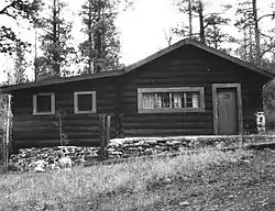 Butterfly Lodge |
June 17, 1992 (#92000686) |
Forest Rd. 245 east of State Route 373 in the Apache National Forest 34°01′08″N 109°26′57″W |
Greer | |
| 4 | Canyon de Chelly National Monument | 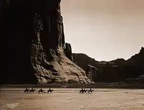 Canyon de Chelly National Monument |
August 25, 1970 (#70000066) |
Eastern side of Chinle 36°08′21″N 109°20′05″W |
Chinle | |
| 5 | Casa Malpais Site | 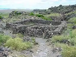 Casa Malpais Site |
October 15, 1966 (#66000936) |
Address restricted 34°09′33″N 109°17′24″W |
Springerville | |
| 6 | Chinle Franciscan Mission Historic District | June 5, 2007 (#07000506) |
Indian Service Route 7 across road and southwest of the Chinle Judicial complex and Police Station 36°09′06″N 109°33′37″W |
Chinle | ||
| 7 | Colter Ranch Historic District |  Colter Ranch Historic District |
July 9, 1993 (#93000626) |
Junction of 4th St. and School Bus Rd. 34°06′24″N 109°19′11″W |
Eagar | |
| 8 | Eagar School |  Eagar School |
July 22, 1993 (#93000624) |
174 S. Main St. 34°06′29″N 109°17′31″W |
Eagar | Now the Eagar police station.[5] |
| 9 | Eagar Townsite Historic District |  Eagar Townsite Historic District |
July 23, 1993 (#93000625) |
Roughly bounded by Central Ave., Main St., 1st Ave. and Eagar St. 2nd Ave, and Harless St., 3rd Ave., and Eagar St. 34°06′45″N 109°17′25″W |
Eagar | |
| 10 | Flattop Site | July 12, 1976 (#76000214) |
Address restricted |
Adamana | ||
| 11 | Hubbell Trading Post National Historic Site | 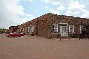 Hubbell Trading Post National Historic Site |
October 15, 1966 (#66000167) |
Western side of Ganado 35°43′32″N 109°35′36″W |
Ganado | |
| 12 | Isaacson Building |  Isaacson Building |
September 12, 1983 (#83002997) |
37 Commercial St.[6] 34°30′22″N 109°21′49″W |
St. Johns | |
| 13 | Kin Tiel |  Kin Tiel |
May 22, 1978 (#78000540) |
Address restricted |
Chambers | |
| 14 | Lake Mountain Lookout Complex | 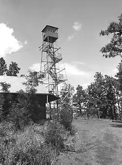 Lake Mountain Lookout Complex |
January 28, 1988 (#87002453) |
Off Vernon McNary Rd. 34°09′28″N 109°46′07″W |
McNary | |
| 15 | Los Burros Ranger Station | 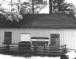 Los Burros Ranger Station |
October 23, 1986 (#86002854) |
Forest Rd. 20 34°08′27″N 109°45′55″W |
McNary | |
| 16 | Lower Zuni River Archeological District | April 29, 1994 (#94000398) |
Address restricted |
St. Johns | ||
| 17 | Lyman Lake Rock Art Site | August 19, 2003 (#97000347) |
Address restricted |
St. Johns | ||
| 18 | Navajo Nation Council Chamber | 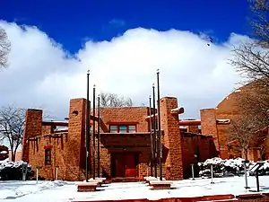 Navajo Nation Council Chamber |
August 18, 2004 (#04001155) |
W008-013 Circle Boulevard 35°40′58″N 109°02′54″W |
Window Rock | |
| 19 | Newspaper Rock Petroglyphs Archeological District | 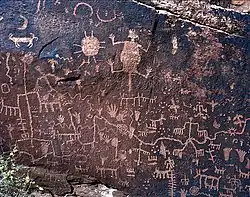 Newspaper Rock Petroglyphs Archeological District |
July 12, 1976 (#76000185) |
Address restricted 34°57′43″N 109°47′57″W |
Adamana | |
| 20 | Painted Desert Community Complex Historic District | 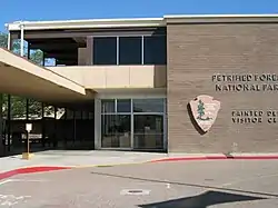 Painted Desert Community Complex Historic District |
April 15, 2005 (#05000284) |
One Park Rd. 35°04′06″N 109°46′50″W |
Petrified Forest National Park | |
| 21 | Painted Desert Inn | 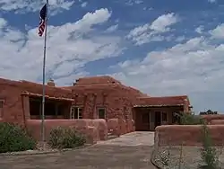 Painted Desert Inn |
October 10, 1975 (#87001421) |
West of Navajo in Petrified Forest National Park, off Interstate 40 35°05′03″N 109°47′06″W |
Navajo | Designated a National Historic Landmark on May 28, 1987 |
| 22 | PS Knoll Lookout Complex | 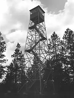 PS Knoll Lookout Complex |
January 28, 1988 (#87002451) |
Apache-Sitgreaves National Forest 33°45′16″N 109°23′52″W |
Maverick | |
| 23 | Puerco Ruin and Petroglyphs | 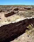 Puerco Ruin and Petroglyphs |
July 12, 1976 (#76000208) |
Address restricted 34°58′29″N 109°47′39″W |
Adamana | |
| 24 | Querino Canyon Bridge |  Querino Canyon Bridge |
September 30, 1988 (#88001623) |
Old U.S. Route 66 over Querino Canyon 35°16′49″N 109°15′28″W |
Houck | |
| 25 | Rattlesnake Point Pueblo | August 2, 2001 (#01000792) |
Lyman Lake State Park 34°21′01″N 109°21′07″W |
St. Johns | ||
| 26 | Sage Memorial Hospital School of Nursing | January 16, 2009 (#09000082) |
Ganado Mission 35°42′40″N 109°32′36″W |
Ganado | ||
| 27 | St. Michael's Mission | 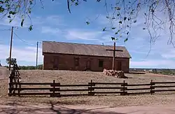 St. Michael's Mission |
May 29, 1975 (#75000335) |
North of Window Rock off State Route 264 35°38′44″N 109°05′53″W |
Window Rock | |
| 28 | Sanders Bridge | September 30, 1988 (#88001618) |
Indian Route 9402 over the Puerco River 35°12′46″N 109°19′47″W |
Sanders | ||
| 29 | Sherwood Ranch Pueblo | August 17, 2005 (#05000887) |
Address restricted |
Springerville | ||
| 30 | Thirty-Fifth Parallel Route | December 6, 1977 (#77000129) |
25 miles east of Holbrook off Interstate 40 35°04′09″N 109°46′14″W |
Holbrook | ||
| 31 | Twin Buttes Archeological District | July 12, 1976 (#76000952) |
Address restricted |
Adamana | ||
| 32 | Water Canyon Administrative Site | June 10, 1993 (#93000511) |
Forest Rd. 285 south of Springerville, Apache-Sitgreaves National Forest 34°03′56″N 109°17′34″W |
Springerville |
Former listings
| [3] | Name on the Register | Image | Date listed | Date removed | Location | City or town | Summary |
|---|---|---|---|---|---|---|---|
| 1 | Barth Hotel | September 5, 1975[7] (#75000334) | February 25, 1985 | 187 E. Commercial St. |
St. Johns | ||
| 2 | Petrified Forest Bridge | September 30, 1988 (#88001616) | November 27, 1998 | Petrified Forest Park Rd. over Rio Puerco |
Navajo vicinity | Vehicular Bridges in Arizona MPS |
See also
| Wikimedia Commons has media related to National Register of Historic Places in Apache County, Arizona. |
References
- The latitude and longitude information provided in this table was derived originally from the National Register Information System, which has been found to be fairly accurate for about 99% of listings. Some locations in this table may have been corrected to current GPS standards.
- "National Register of Historic Places: Weekly List Actions". National Park Service, United States Department of the Interior. Retrieved on January 29, 2021.
- Numbers represent an alphabetical ordering by significant words. Various colorings, defined here, differentiate National Historic Landmarks and historic districts from other NRHP buildings, structures, sites or objects.
- The eight-digit number below each date is the number assigned to each location in the National Register Information System database, which can be viewed by clicking the number.
- "Eagar Police Department". Retrieved 2013-09-18.
- Building is located on even-numbered side of street; see 2017 photo, showing Isaacson Building next to 70 E. Commercial.
- http://www.nps.gov/history/nr/listings/Weekly_Register_List_1985.pdf NRHP 1985 Weekly listings
 | |||
| Topics | |
|---|---|
| Lists by state |
|
| Lists by insular areas | |
| Lists by associated state | |
| Other areas | |
| Related | |
| |
This article is issued from Wikipedia. The text is licensed under Creative Commons - Attribution - Sharealike. Additional terms may apply for the media files.