National Register of Historic Places listings in La Paz County, Arizona
This is a list of the National Register of Historic Places listings in La Paz County, Arizona.
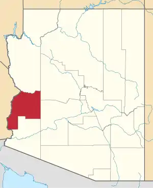
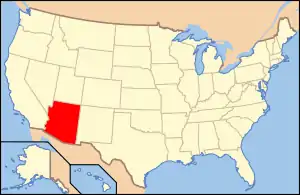
Location of La Paz County in Arizona
This is intended to be a complete list of the properties and districts on the National Register of Historic Places in La Paz County, Arizona, United States. The locations of National Register properties and districts for which the latitude and longitude coordinates are included below, may be seen in a map.[1]
There are 10 properties and districts listed on the National Register in the county.
- This National Park Service list is complete through NPS recent listings posted February 5, 2021.[2]
Current listings
| [3] | Name on the Register | Image | Date listed[4] | Location | City or town | Description |
|---|---|---|---|---|---|---|
| 1 | Eagletail Petroglyph Site | September 28, 1988 (#88001570) |
Address Restricted |
Hyder | ||
| 2 | Harquahala Mountain Smithsonian Solar Observatory Historic District | May 1, 1997 (#97000346) |
Harquahala Mountain (Wilderness), southwest of Gladden 33°48′48″N 113°20′47″W |
Gladden | ||
| 3 | Harquahala Peak Observatory | October 3, 1975 (#75000370) |
East of Wenden off U.S. Route 60 33°48′48″N 113°20′44″W |
Wenden | ||
| 4 | Hi Jolly Monument | 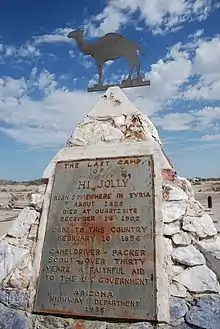 Hi Jolly Monument |
February 28, 2011 (#11000054) |
Intersection of W. Elsie and Hi Jolly Lanes. 33°39′52″N 114°14′11″W |
Quartzsite | Pyramidal Monuments in Arizona MPS |
| 5 | Rhoda Nohlechek House | May 10, 1996 (#96000529) |
Northwestern corner of the junction of 2nd St. and Date Ave. 33°49′24″N 113°32′27″W |
Wenden | ||
| 6 | Old La Paz | August 25, 1970 (#70000117) |
Address Restricted |
Ehrenberg | ||
| 7 | Old Presbyterian Church | 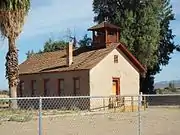 Old Presbyterian Church |
June 3, 1971 (#71000122) |
Southwest of Parker on 2nd Ave. 34°06′45″N 114°18′48″W |
Parker | |
| 8 | Parker Jail | 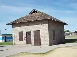 Parker Jail |
April 3, 1975 (#75000369) |
Northern side of Agency Rd. in Pop Harvey Park 34°08′55″N 114°17′39″W |
Parker | |
| 9 | Poston Elementary School, Unit 1, Colorado River Relocation Center | 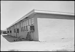 Poston Elementary School, Unit 1, Colorado River Relocation Center |
October 16, 2012 (#12001010) |
Poston Rd. 0.4 miles (0.64 km) west of Mohave Rd. 33°59′40″N 114°24′24″W |
Parker | Elementary school at Poston War Relocation Center[5] |
| 10 | Ripley Intaglios | November 20, 1975 (#75000368) |
Address Restricted |
Ehrenberg |
See also
| Wikimedia Commons has media related to National Register of Historic Places in La Paz County, Arizona. |
References
- The latitude and longitude information provided in this table was derived originally from the National Register Information System, which has been found to be fairly accurate for about 99% of listings. Some locations in this table may have been corrected to current GPS standards.
- "National Register of Historic Places: Weekly List Actions". National Park Service, United States Department of the Interior. Retrieved on February 5, 2021.
- Numbers represent an alphabetical ordering by significant words. Various colorings, defined here, differentiate National Historic Landmarks and historic districts from other NRHP buildings, structures, sites or objects.
- The eight-digit number below each date is the number assigned to each location in the National Register Information System database, which can be viewed by clicking the number.
- Poston Relocation Center, National Park Service, 2000-09-01. Accessed 2014-01-02.
| Topics | |
|---|---|
| Lists by state |
|
| Lists by insular areas | |
| Lists by associated state | |
| Other areas | |
| Related | |
| |
 | |||
Municipalities and communities of La Paz County, Arizona, United States | ||
|---|---|---|
| Towns | | |
| CDPs | ||
| Populated places | ||
| Indian reservations | ||
| Ghost towns | ||
| ||
This article is issued from Wikipedia. The text is licensed under Creative Commons - Attribution - Sharealike. Additional terms may apply for the media files.