Spokane County, Washington
Spokane County is a county located in the U.S. state of Washington. As of the 2010 census the population was 471,221, making it the fourth-most populous county in Washington state.[2] The largest city and county seat is Spokane,[3] the second largest city in the state after Seattle. The county is named after the Spokane tribe.
Spokane County | |
|---|---|
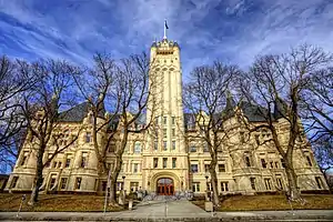 Spokane County Courthouse | |
 Seal | |
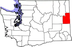 Location within the U.S. state of Washington | |
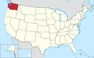 Washington's location within the U.S. | |
| Coordinates: 47°37′N 117°24′W | |
| Country | |
| State | |
| Founded | January 29, 1858 (created) January 19, 1864 (annexed to Stevens Co.) October 30, 1879 (separated from Stevens Co.) |
| Named for | Spokane people |
| Seat | |
| Largest city | Spokane |
| Area | |
| • Total | 1,781 sq mi (4,610 km2) |
| • Land | 1,764 sq mi (4,570 km2) |
| • Water | 17 sq mi (40 km2) 0.9%% |
| Population (2010) | |
| • Total | 471,221 |
| • Estimate (2019) | 522,798 |
| • Density | 275/sq mi (106/km2) |
| Time zone | UTC−8 (Pacific) |
| • Summer (DST) | UTC−7 (PDT) |
| Congressional district | 5th |
| Website | www |
Spokane County is part of the Spokane-Spokane Valley, WA Metropolitan Statistical Area, which is also part of the greater Spokane-Coeur d'Alene Combined Statistical Area that includes nearby Kootenai County, Idaho.
History
Spokane County was established by the Washington legislature effective January 29, 1858. It was annexed by Stevens County on January 19, 1864, and re-created on October 30, 1879.[4][5] The first post office in the county was located at Spokane Bridge.[6]
Geography
According to the U.S. Census Bureau, the county has a total area of 1,781 square miles (4,610 km2), of which 1,764 square miles (4,570 km2) is land and 17 square miles (44 km2) (0.9%) is water.[7] The lowest point in the county is the Spokane River behind Long Lake Dam (boundary of Stevens County) at 1538 feet (468 m) above sea level. (There is virtually no change in elevation between the dam and the mouth of the Little Spokane River inside Riverside State Park.) The highest point in the county is the summit of Mount Spokane at 5,887 ft (1,794 m). NAVD 88[8]
Lakes and reservoirs
- Medical Lake
- West Medical Lake
- Liberty Lake
- Newman Lake
- Shelley Lake
Notable summits and peaks
Notable parks
National protected area
Major highways
Adjacent counties
- Stevens County – northwest
- Pend Oreille County – north
- Bonner County, Idaho – northeast
- Kootenai County, Idaho – east
- Benewah County, Idaho – southeast
- Whitman County – south
- Lincoln County – west
Demographics
| Historical population | |||
|---|---|---|---|
| Census | Pop. | %± | |
| 1860 | 996 | — | |
| 1870 | 2,000 | 100.8% | |
| 1880 | 4,262 | 113.1% | |
| 1890 | 37,487 | 779.6% | |
| 1900 | 57,542 | 53.5% | |
| 1910 | 139,404 | 142.3% | |
| 1920 | 141,289 | 1.4% | |
| 1930 | 150,477 | 6.5% | |
| 1940 | 164,652 | 9.4% | |
| 1950 | 221,561 | 34.6% | |
| 1960 | 278,333 | 25.6% | |
| 1970 | 287,487 | 3.3% | |
| 1980 | 341,835 | 18.9% | |
| 1990 | 361,364 | 5.7% | |
| 2000 | 417,939 | 15.7% | |
| 2010 | 471,221 | 12.7% | |
| 2019 (est.) | 522,798 | [9] | 10.9% |
| US Decennial Census[10] 1790–1960[11] 1900–1990[12] 1990–2000[13] 2010–2019[2] | |||
2000 census
As of the 2000 United States Census,[14] there were 417,939 people, 163,611 households, and 106,019 families in the county. The population density was 237 inhabitants per square mile (92/km2). There were 175,005 housing units at an average density of 99 per square mile (38/km2). The racial makeup of the county was 88.62% White, 2.00% Black or African American, 1.40% Native American, 1.88% Asian, 0.16% Pacific Islander, 0.82% from other races, and 2.76% from two or more races. 2.77% of the population were Hispanic or Latino of any race. 22.0% were of German, 10.7% Irish, 9.9% English, 7.6% United States or American and 6.4% Norwegian ancestry.
There were 163,611 households, out of which 32.40% had children under the age of 18 living with them, 49.90% were married couples living together, 11.00% had a female householder with no husband present, and 35.20% were non-families. 28.10% of all households were made up of individuals, and 9.60% had someone living alone who was 65 years of age or older. The average household size was 2.46 and the average family size was 3.02.
In the county, the population was spread out, with 25.70% under the age of 18, 10.60% from 18 to 24, 28.90% from 25 to 44, 22.40% from 45 to 64, and 12.40% who were 65 years of age or older. The median age was 35 years. For every 100 females there were 96.40 males. For every 100 females age 18 and over, there were 93.60 males.
The median income for a household in the county was $37,308, and the median income for a family was $46,463. Males had a median income of $35,097 versus $25,526 for females. The per capita income for the county was $19,233. About 8.30% of families and 12.30% of the population were below the poverty line, including 14.20% of those under age 18 and 8.10% of those age 65 or over.
2010 census
As of the 2010 United States Census, there were 471,221 people, 187,167 households, and 118,212 families residing in the county.[15] The population density was 267.2 inhabitants per square mile (103.2/km2). There were 201,434 housing units at an average density of 114.2 per square mile (44.1/km2).[16] The racial makeup of the county was 89.2% white, 2.1% Asian, 1.7% black or African American, 1.5% American Indian, 0.4% Pacific islander, 1.2% from other races, and 3.8% from two or more races. Those of Hispanic or Latino origin made up 4.5% of the population.[15] In terms of ancestry, 27.0% were German, 15.4% were Irish, 13.5% were English, 6.9% were Norwegian, and 4.4% were American.[17]
Of the 187,167 households, 30.9% had children under the age of 18 living with them, 47.2% were married couples living together, 11.2% had a female householder with no husband present, 36.8% were non-families, and 28.6% of all households were made up of individuals. The average household size was 2.44 and the average family size was 2.99. The median age was 36.8 years.[15]
The median income for a household in the county was $47,250 and the median income for a family was $59,999. Males had a median income of $44,000 versus $33,878 for females. The per capita income for the county was $25,127. About 9.1% of families and 14.1% of the population were below the poverty line, including 17.0% of those under age 18 and 8.5% of those age 65 or over.[18]
Law and government
Spokane County is governed by a partisan Board of County Commissioners, one from each of three districts. They run in a partisan primary election within their own district, then compete countywide in the general election. Other elected officials include the Sheriff, Auditor (who is also responsible for elections), Assessor, Treasurer, and Prosecutor, which are also partisan offices. Spokane County has an appointed Medical Examiner. The current[19] commissioners for Spokane County are Josh Kerns, Mary Kuney, and Al French, from the 1st, 2nd, and 3rd county districts respectively.
Transportation planning within the county is handled by the Spokane Regional Transportation Council (SRTC), a metropolitan planning organization that was created in 1962. The SRTC distributes federal and state funds for transportation projects and is tasked with updating the long-range transportation plan for Spokane County.[20]
Spokane County has generally been a reliably Republican county in presidential elections over the last half-century. It did, however, give a plurality of votes to Bill Clinton in both of his presidential runs.
| Year | Republican | Democratic | Third parties |
|---|---|---|---|
| 2020 | 50.3% 148,576 | 46.0% 135,765 | 3.7% 11,089 |
| 2016 | 48.1% 113,435 | 39.7% 93,767 | 12.2% 28,848 |
| 2012 | 51.1% 115,285 | 45.3% 102,295 | 3.6% 8,174 |
| 2008 | 49.0% 108,314 | 47.9% 105,786 | 3.1% 6,907 |
| 2004 | 55.1% 111,606 | 43.2% 87,490 | 1.7% 3,491 |
| 2000 | 51.9% 89,299 | 43.4% 74,604 | 4.8% 8,209 |
| 1996 | 41.8% 66,628 | 45.1% 71,727 | 13.1% 20,877 |
| 1992 | 35.5% 59,984 | 41.1% 69,526 | 23.4% 39,622 |
| 1988 | 49.4% 68,787 | 49.2% 68,520 | 1.3% 1,843 |
| 1984 | 59.0% 88,043 | 39.9% 59,620 | 1.1% 1,673 |
| 1980 | 55.5% 78,096 | 35.0% 49,263 | 9.5% 13,326 |
| 1976 | 53.4% 68,290 | 43.5% 55,660 | 3.1% 4,004 |
| 1972 | 59.4% 74,320 | 35.4% 44,337 | 5.2% 6,528 |
| 1968 | 47.6% 52,650 | 44.7% 49,423 | 7.7% 8,521 |
| 1964 | 44.3% 49,387 | 55.7% 62,092 | 0.1% 102 |
| 1960 | 51.6% 59,557 | 48.2% 55,553 | 0.2% 259 |
| 1956 | 55.2% 60,335 | 44.7% 48,833 | 0.1% 119 |
| 1952 | 55.2% 56,958 | 44.4% 45,827 | 0.4% 451 |
| 1948 | 41.7% 37,086 | 55.8% 49,649 | 2.5% 2,253 |
| 1944 | 44.2% 36,359 | 55.3% 45,491 | 0.6% 456 |
| 1940 | 42.2% 33,228 | 56.9% 44,852 | 0.9% 713 |
| 1936 | 28.5% 19,951 | 68.6% 48,117 | 2.9% 2,057 |
| 1932 | 38.2% 24,848 | 56.7% 36,953 | 5.1% 3,324 |
| 1928 | 65.5% 35,858 | 33.8% 18,527 | 0.7% 373 |
| 1924 | 49.3% 23,403 | 12.7% 6,036 | 38.0% 18,034 |
| 1920 | 60.6% 26,219 | 31.0% 13,412 | 8.5% 3,670 |
| 1916 | 45.2% 19,503 | 49.5% 21,339 | 5.3% 2,278 |
| 1912 | 11.9% 4,205 | 30.8% 10,845 | 57.3% 20,218 |
| 1908 | 58.7% 11,719 | 32.8% 6,557 | 8.5% 1,694 |
| 1904 | 71.7% 10,258 | 18.2% 2,602 | 10.1% 1,445 |
| 1900 | 49.8% 5,515 | 46.3% 5,125 | 3.8% 425 |
| 1896 | 31.2% 2,701 | 67.4% 5,829 | 1.4% 122 |
| 1892 | 45.5% 3,367 | 30.3% 2,247 | 24.2% 1,794 |
Communities
Cities
Census-designated places
Unincorporated communities
- Amber
- Buckeye
- Chattaroy
- Colbert
- Deep Creek
- Denison
- Duncan
- Dynamite
- Elk
- Espanola
- Freeman
- Garden Springs
- Geiger Heights
- Glenrose
- Greenacres
- Green Bluff
- Hazard
- Highland
- Manito
- Marshall
- Mica
- Milan
- Moab
- Mount Hope
- Newman Lake
- Nine Mile Falls
- Orchard Prairie
- Peone
- Plaza
- Riverside
- Seven Mile
- Silver Lake
- Spokane Bridge
- Spring Valley
- Stringtown
- Tyler
- Valleyford
References
- Autunite from Daybreak Mine at Mindat.org
- "State & County QuickFacts". US Census Bureau. Retrieved January 7, 2014.
- "Find a County". National Association of Counties. Retrieved June 7, 2011.
- "Milestones for Washington State History – Part 2: 1851 to 1900". HistoryLink.org. March 6, 2003.
- "Spokane County, Washington: Historical Dates and Maps". Archived from the original on December 14, 2007. Retrieved January 1, 2008.
- "Spokane Valley — Thumbnail History". HistoryLink. Retrieved July 21, 2019.
- "2010 Census Gazetteer Files". US Census Bureau. August 22, 2012. Retrieved July 16, 2015.
- "Y". NGS data sheet. U.S. National Geodetic Survey.
- "American FactFinder". Retrieved April 11, 2020.
- "US Decennial Census". US Census Bureau. Retrieved January 7, 2014.
- "Historical Census Browser". University of Virginia Library. Retrieved January 7, 2014.
- "Population of Counties by Decennial Census: 1900 to 1990". US Census Bureau. Retrieved January 7, 2014.
- "Census 2000 PHC-T-4. Ranking Tables for Counties: 1990 and 2000" (PDF). US Census Bureau. Retrieved January 7, 2014.
- "U.S. Census website". US Census Bureau. Retrieved May 14, 2011.
- "Profile of General Population and Housing Characteristics: 2010 Demographic Profile Data". US Census Bureau. Archived from the original on February 13, 2020. Retrieved March 6, 2016.
- "Population, Housing Units, Area, and Density: 2010 – County". US Census Bureau. Archived from the original on February 13, 2020. Retrieved March 6, 2016.
- "Selected Social Characteristics in the United States - 2006–2010 American Community Survey 5-Year Estimates". US Census Bureau. Archived from the original on February 13, 2020. Retrieved March 6, 2016.
- "Selected Economic Characteristics – 2006–2010 American Community Survey 5-Year Estimates". US Census Bureau. Archived from the original on February 13, 2020. Retrieved March 6, 2016.
- As of October 2018
- Deshais, Nicholas (June 12, 2019). "Spokane Tribe will get a voice in transportation planning, a move that sparked controversy among Spokane officials". Spokesman-Review. Retrieved December 7, 2019.
- Leip, David. "Dave Leip's Atlas of U.S. Presidential Elections". uselectionatlas.org. Retrieved April 10, 2018.
External links
| Wikimedia Commons has media related to Spokane County, Washington. |
Places adjacent to Spokane County, Washington | ||||||||||
|---|---|---|---|---|---|---|---|---|---|---|
| ||||||||||
Municipalities and communities of Spokane County, Washington, United States | ||
|---|---|---|
| Cities | Map of Washington highlighting Spokane County | |
| Towns | ||
| CDPs | ||
| Unincorporated communities | ||
| Ghost towns/Neighborhoods | ||
| ||
| Authority control |
|---|