U.S. Route 64 in Arizona and New Mexico
U.S. Route 64 (US 64) is a U.S. Highway in the American states of Arizona and New Mexico. US 64 runs from the Four Corners area in Arizona to the east coast of North Carolina. In Arizona, the highway starts at U.S. Route 160 (US 160) heading southeast for 4.5 miles (7.2 km) before entering New Mexico near the town of Beclabito. Through New Mexico the highway passes through Shiprock, Bloomfield, Tierra Amarilla and Tres Piedras, sharing a short concurrency with I-25 near Raton, before heading east through Clayton to the Oklahoma state line.
| |||||||||
|---|---|---|---|---|---|---|---|---|---|
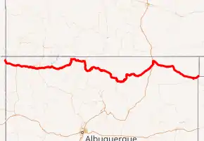
US 64 highlighted in red | |||||||||
| Route information | |||||||||
| Maintained by ADOT and NMDOT | |||||||||
| Length | 429.912 mi (691.876 km) | ||||||||
| Existed | November 11, 1926[3]–present | ||||||||
| History | AZ: Designated December 2, 1988 NM: Designated November 11, 1926 | ||||||||
| Major junctions | |||||||||
| West end | |||||||||
| |||||||||
| East end | |||||||||
| Location | |||||||||
| Counties | AZ: Apache NM: San Juan, Rio Arriba, Taos, Colfax, Union | ||||||||
| Highway system | |||||||||
| |||||||||

Route description
U.S. Route 64 (US 64) starts at an intersection with US 160 at Teec Nos Pos on the Navajo Nation. The highway then heads southeast passing an intersection with Bureau of Indian Affairs Route 5028 (BIA 5028) at the edge of town across the highway from the Teec Nos Pos Trading Post. The highway then cuts through a mesa before making a slight curve south by southeast. Past the mesa, US 64 passes through sparse ranch land, intersecting BIA 5111 before turning slightly eastward. After passing an intersection with BIA 5113, US 64 crosses the New Mexico state line.[4]
Entering from Arizona, US 64 continues into the town of Beclabito, traveling to Shiprock. There US 64 makes a concurrency with US 491 for 0.5 miles (0.80 km). US 64 continues east into the city of Farmington, where it is multiplexed with unsigned State Road 5001 between junctions with US 64 Business. Then it passes through Bloomfield, followed by the towns of Blanco and Navajo City. After entering the Rocky Mountains, US 64 has a concurrency with US 84 from Chromo Mountain to Tierra Amarilla.
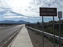
The highway then passes through Tres Piedras before crossing via the Rio Grande Gorge Bridge and heading into Taos. US 64 continues through the towns of Eagle Nest and Cimarron before eventually reaching I-25. The two highways bring up a short concurrency before US 64 turns northwest off of I-25 in Raton, then continuing to travel east, this time bringing up a concurrency with US 87 through the towns of Capulin, Des Moines, Grenville, and Mount Dora. The two highways split in Clayton, and US 64 forms another new concurrency with US 56 and US 412. The three highways barely touch the Texas Panhandle before continuing into Oklahoma.[4]
History
When originally designated on November 11, 1926, U.S. Route 64 (US 64) had its western terminus at US 385 in Capulin, New Mexico.[3] In 1933, US 64 had been extended to end at US 85 in Santa Fe, New Mexico, replacing all of the previously designated US 485 between Raton and Santa Fe, through Taos.[5][3] On November 11, 1972, US 64 was truncated from Santa Fe to Taos, then extended west through Tres Piedras, Brazos, Monero and Bloomfield to US 550 in Farmington.[6] The new routing replaced all of New Mexico State Road 111 (NM 111) and NM 553 between Taos and Tierra Amarilla. US 64 now shared a concurrency with US 84 between Tierra Amarilla and a highway junction 4 miles (6.4 km) east of Monero. US 64 then replaced all of NM 17 between US 84 and US 550 in Farmington.[7][3] On December 2, 1988, or sometime after that date, US 64 was further extended over Arizona State Route 504 and New Mexico State Road 504 to a junction with US 160 in Teec Nos Pos, Arizona near Four Corners.[8][4] Today, the western terminus of US 64 remains at Teec Nos Pos.[1]
New Mexico State Road 5001
| |
|---|---|
| Location | Farmington, New Mexico |
| Length | 3.244 mi[9] (5.221 km) |
State Road 5001 (NM 5001) is an unsigned 3.244-mile-long (5.221 km) state highway in the U.S. state of New Mexico. For its entire length, NM 5001 is multiplexed with US 64, and is also known as Murray Drive. NM 5001's western terminus is at US 64 Bus. (Main Street) in Farmington, and the eastern terminus is at US 64 Bus. (Broadway Avenue) in Farmington. NM 5001 is one of only three four-digit state highways in New Mexico (the others being NM 1113 and NM 6563).[2]
Junction list
| State | County | Location | mi [2][1][11][12][13][4] | km | Destinations[4] | Notes |
|---|---|---|---|---|---|---|
| Arizona | Apache | Teec Nos Pos | 465.400 | 748.989 | National western terminus; US 64 east to the New Mexico state line is former SR 504 | |
| 469.557 0.000 | 755.679 0.000 | Arizona–New Mexico line | ||||
| New Mexico | San Juan | Shiprock | 21.935 | 35.301 | Western end of US 491 concurrency; former US 666; US 64 west to the Arizona state line is former NM 504 | |
| 22.787 | 36.672 | Eastern end of US 491 concurrency; former US 666 | ||||
| Farmington | 48.371 | 77.846 | ||||
| 50.114 | 80.651 | Former US 550 north | ||||
| Begin NM 5001 | ||||||
| 51.472 | 82.836 | |||||
| 52.400 | 84.330 | End NM 5001 | ||||
| 53.842 | 86.650 | |||||
| Bloomfield | 63.862 | 102.776 | Western end of US 550 concurrency | |||
| 64.177 | 103.283 | Eastern end of US 550 concurrency | ||||
| Blanco | 72.798 | 117.157 | ||||
| | 75.473 | 121.462 | ||||
| Rio Arriba | Navajo City | 88.301 | 142.107 | |||
| | 101.687 | 163.649 | ||||
| | 124.283 | 200.014 | ||||
| | 148.222 | 238.540 | Western end of US 84 concurrency | |||
| Chama | 160.622 | 258.496 | ||||
| Brazos | 169.477 | 272.747 | ||||
| Brazos–Los Ojos line | 171.092 | 275.346 | ||||
| Los Ojos | 171.171 | 275.473 | ||||
| 172.242 | 277.197 | |||||
| Tierra Amarilla | 172.894 | 278.246 | ||||
| 173.634 | 279.437 | |||||
| 174.560 | 280.927 | Eastern end of US 84 concurrency | ||||
| 174.740 | 281.217 | |||||
| | 215.950 | 347.538 | ||||
| Taos | Tres Piedras | 222.873 | 358.679 | |||
| | 250.000 | 402.336 | ||||
| Taos | 254.025 | 408.814 | ||||
| 255.901 | 411.833 | |||||
| Colfax | Angel Fire | 275.536 | 443.432 | |||
| Eagle Nest | 284.678 | 458.145 | ||||
| 285.270 | 459.098 | |||||
| Cimarron | 308.730 | 496.853 | ||||
| 309.299 | 497.768 | |||||
| 313.020 | 503.757 | Access to areas in Philmont Scout Ranch | ||||
| | 320.652 | 516.039 | ||||
| | 334.755 | 538.736 | ||||
| | 343.875 448.010 | 553.413 721.002 | Western end of I-25/US 85 concurrency; I-25 exit 446; mileposts change to reflect I-25 | |||
| Raton | 451.250 0.000 | 726.216 0.000 | Eastern end of I-25/US 85 concurrency; western end of I-25 Bus. concurrency; I-25 exit 450; mileposts change to reflect I-25 Bus. | |||
| 0.275 | 0.443 | |||||
| 1.463 348.754 | 2.354 561.265 | Eastern end of I-25 Bus. concurrency; mileposts change to reflect US 64 | ||||
| 349.282 | 562.115 | Western end of US 87 concurrency; I-25 exit 451 | ||||
| | 361.054 | 581.060 | ||||
| Union | Capulin | 376.663 | 606.180 | Counterclockwise terminus of NM 325 | ||
| Des Moines | 385.406 | 620.251 | Clockwise terminus of NM 325 | |||
| Grenville | 403.753 | 649.777 | ||||
| Clayton | 430.299 | 692.499 | ||||
| 430.634 82.530 | 693.038 132.819 | Eastern end of US 87 concurrency; western end of US 56/US 412 concurrency; mileposts change to reflect US 56 | ||||
| 83.250 | 133.978 | |||||
| | 85.890 | 138.227 | ||||
| | 94.172 | 151.555 | Continuation into Oklahoma | |||
1.000 mi = 1.609 km; 1.000 km = 0.621 mi
| ||||||
References
- Arizona Department of Transportation. "2013 ADOT Highway Log" (PDF). Retrieved July 1, 2019.
- "Posted Route–Legal Description" (PDF). New Mexico Department of Transportation. March 16, 2010. p. 20. Retrieved October 17, 2018.
- Bureau of Public Roads & American Association of State Highway Officials (November 11, 1926). United States System of Highways Adopted for Uniform Marking by the American Association of State Highway Officials (Map). 1:7,000,000. Washington, DC: United States Geological Survey. OCLC 32889555. Retrieved November 7, 2013 – via University of North Texas Libraries.
- Google (August 2, 2019). "U.S. Route 64 in Arizona and New Mexico" (Map). Google Maps. Google. Retrieved August 2, 2019.
- New Mexico State Highway Department (1933). Official Road Map of New Mexico (Map). 1:1,584,000. Cartography by B.C. Broome. Santa Fe: State of New Mexico. Retrieved August 2, 2019 – via University of New Mexico Digital Collections.
- U.S. Route Numbering Subcommittee (November 11, 1972). "U.S. Route Numbering Committee Agenda" (PDF) (Report). Washington, DC: American Association of State Highway Officials. p. 1. Retrieved August 2, 2019 – via Wikimedia Commons.
Discontinue the U.S. 64 designation between Taos and Santa Fe and designate as U.S. 64 that route between Taos and Farmington over S.R. 111, 553 and 17 through Tres Piedras, Brazos, Monero and Bloomfield.
- New Mexico State Highway Department (1973). Official Road Map of New Mexico (Map). 1:1,267,200. Cartography by Rand McNally & Co. Chicago, Ill.: State of New Mexico.
- Special Committee on U.S. Route Numbering (December 2, 1988). "Route Numbering Committee Agenda" (PDF) (Report). Washington, DC: American Association of State Highway and Transportation Officials. p. 4. Retrieved August 2, 2019 – via Wikimedia Commons.
Beginning at the present terminus of U.S. Route 64 at Farmington, New Mexico, then westerly over U.S. Route 550 to the intersection of State Road 504 in Shiprock, N.M., then westerly over S.R. 504 to the intersection of U.S. Route 160 in Teec Nos Pos, Arizona.
- "Posted Route: Legal Description" (PDF). New Mexico Department of Transportation. March 16, 2010. p. 91. Retrieved October 25, 2018.
- "District 5 Projects". New Mexico Department of Transportation. Archived from the original on August 13, 2016. Retrieved December 22, 2015.
- "TIMS Road Segments by Posted Route/Point with AADT Info; US-Routes" (PDF). New Mexico Department of Transportation. April 3, 2013. p. 22. Retrieved January 3, 2019.
- "TIMS Road Segments by Posted Route/Point with AADT Info; Interstates" (PDF). New Mexico Department of Transportation. April 3, 2013. p. 22. Retrieved January 3, 2019.
- Staff (March 16, 2010). "Posted Route–Legal Description; Business Loops" (PDF). New Mexico Department of Transportation, Data Management Bureau. p. 3. Retrieved January 3, 2019.
External links
| Previous state: Terminus |
Arizona | Next state: New Mexico |
| Previous state: Arizona |
New Mexico | Next state: Oklahoma |