Lake of the Woods County, Minnesota
Lake of the Woods County is a county in the northwestern part of the U.S. state of Minnesota. As of the 2010 United States Census, the population was 4,045,[1] making it the second-least populous county in Minnesota. Its county seat is Baudette.[2]
Lake of the Woods County | |
|---|---|
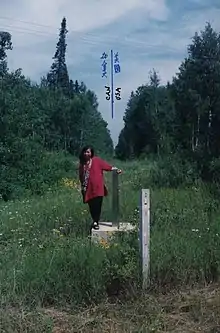 US-Canada border monument no. 919 | |
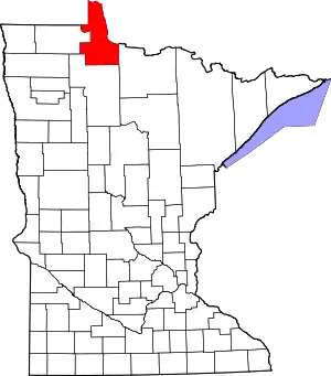 Location within the U.S. state of Minnesota | |
 Minnesota's location within the U.S. | |
| Coordinates: 48°46′N 94°54′W | |
| Country | |
| State | |
| Founded | November 28, 1922 (created by vote) January 1, 1923 (organized) |
| Named for | Lake of the Woods (lake) |
| Seat | Baudette |
| Largest city | Baudette |
| Area | |
| • Total | 1,775 sq mi (4,600 km2) |
| • Land | 1,298 sq mi (3,360 km2) |
| • Water | 477 sq mi (1,240 km2) 27%% |
| Population (2010) | |
| • Total | 4,045 |
| • Estimate (2019) | 3,740 |
| • Density | 2.9/sq mi (1.1/km2) |
| Time zone | UTC−6 (Central) |
| • Summer (DST) | UTC−5 (CDT) |
| Congressional district | 7th |
| Website | Lake of the Woods County, Minnesota |
The county contains the Northwest Angle, the northernmost point of the Lower 48 States, and the U.S. portion of Lake of the Woods, shared with Canada. The county also includes the exclave of Elm Point. Since Alaska has no counties, Lake of the Woods is the northernmost county in the United States. It is also the only county in the United States with four words in its name, although there is a parish in Louisiana called St. John the Baptist Parish, and the United States Census Bureau treats parishes as county equivalents for census purposes.
History
Lake of the Woods County was named for the lake that covers a large portion of it. Jacques de Noyon, a Frenchman who came from Trois Rivières, Quebec, explored the area in 1688 and was the first European to see the lake. He named it Lac aux Îles, "Lake of the Islands".
In 1885 the region got its first settler, Wilhelm Zippel, a German immigrant and fisherman. He settled on the lake's south shore in a place now called Zippel Bay. Shortly after, Alonzo Wheeler settled on the lake's southwest side at a place now called Wheeler's Point.
A wildfire, known as the Baudette Fire of 1910, broke out in October of that year, burning 300,000 acres (1,200 km2) and destroying the towns of Spooner, Baudette, Graceton, Pitt, Williams, and Cedar Spur.[3][4]
Lake of the Woods County's government was organized on January 1, 1923, with Baudette as the county seat. It is Minnesota's newest county; county voters approved separating the northern townships of Beltrami County into a separate unit on November 28, 1922.[5][6]
Geography
Lake of the Woods County lies on Minnesota's border with Canada across the Rainy River, which flows northwest along the border to discharge into Lake of the Woods; its northwest border abuts Manitoba. The northern part of the county (the Northwest Angle) is separated from the rest of the county by the lake and thus has no land contact with the rest of the United States; land access to that part of the county is through Manitoba. Access by water or ice routes is possible. The Rapid River flows northeast through the southeastern part of the county to its discharge point into the Rainy River, near the county's northeast corner.
Lake of the Woods County's terrain consists of low rolling hills, partly wooded, devoted to agriculture.[7] The terrain slopes to the east and north.[8] Its highest point is a small protuberance one mile (1.6 km) west of Norris Camp,[7] at 1,316' (401m) ASL.[9] The county has an area of 1,775 square miles (4,600 km2), of which 1,298 square miles (3,360 km2) is land and 477 square miles (1,240 km2) (27%) is water.[10]
Major highways
Adjacent counties and districts
- Kenora District, Ontario - northeast
- Rainy River District, Ontario - northeast
- Koochiching County - southeast
- Beltrami County - south
- Roseau County - west
- Rural Municipality of Piney, Manitoba - west
- Buffalo Point, Manitoba - west
- Division No. 1, Unorganized, Manitoba - northwest
Protected areas[7]
- Beltrami Island State Forest (part)
- Garden Island State Recreation Area
- Mulligan Lake Peatland Scientific and Natural Area
- Norris Camp Peatland Scientific and Natural Area
- Pine Island State Forest (part)
- Red Lake Peatland Scientific and Natural Area (part)
- Winter Road Lakes Peatland Scientific and Natural Area
- Zippel Bay State Park
Lakes[7]
- Browns Lake
- Lake of the Woods
- Lost Lake
- Winter Road Lake
Demographics
| Historical population | |||
|---|---|---|---|
| Census | Pop. | %± | |
| 1930 | 4,194 | — | |
| 1940 | 5,975 | 42.5% | |
| 1950 | 4,955 | −17.1% | |
| 1960 | 4,304 | −13.1% | |
| 1970 | 3,987 | −7.4% | |
| 1980 | 3,764 | −5.6% | |
| 1990 | 4,076 | 8.3% | |
| 2000 | 4,522 | 10.9% | |
| 2010 | 4,045 | −10.5% | |
| 2019 (est.) | 3,740 | [11] | −7.5% |
| US Decennial Census[12] 1790-1960[13] 1900-1990[14] 1990-2000[15] 2010-2019[1] | |||
2000 census
As of the 2000 United States Census, there were 4,522 people, 1,903 households, and 1,267 families in the county. The population density was 3.48/sqmi (1.35/km2). There were 3,238 housing units at an average density of 2.49/sqmi (0.96/km2). The racial makeup of the county was 97.21% White/Caucasian, 0.29% Black/African American, 1.13% Native American, 0.24% Asian, 0.11% from other races, and 1.02% from two or more races. 0.64% of the population were Hispanic or Latino of any race. 26.2% were of Norwegian, 22.3% German, 8.9% Swedish, 5.8% American and 5.0% English ancestry.
There were 1,903 households, out of which 29.20% had children under the age of 18 living with them, 57.40% were married couples living together, 5.30% had a female householder with no husband present, and 33.40% were non-families. 29.70% of all households were made up of individuals, and 12.90% had someone living alone who was 65 years of age or older. The average household size was 2.35 and the average family size was 2.93.
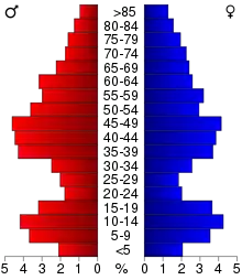
The county population contained 24.70% under the age of 18, 5.70% from 18 to 24, 25.10% from 25 to 44, 27.20% from 45 to 64, and 17.20% who were 65 years of age or older. The median age was 42 years. For every 100 females there were 101.00 males. For every 100 females age 18 and over, there were 102.60 males.
The median income for a household in the county was $32,861, and the median income for a family was $38,936. Males had a median income of $30,469 versus $24,813 for females. The per capita income for the county was $16,976. About 6.70% of families and 9.80% of the population were below the poverty line, including 8.30% of those under age 18 and 10.60% of those age 65 or over.
Communities
Cities
- Baudette (county seat)
- Roosevelt (partly in Roseau County)
- Williams
Census-designated place
Unincorporated communities
- Arnesen[7]
- Birch Beach
- Carp[7]
- Clementson
- Faunce[7]
- Graceton
- Hackett
- Long Point[7]
- Lude
- Oak Island
- Penasse
- Pitt
- Sandy Shores
- Wheeler's Point
Townships
Although all the townships are named, as of 2001, there are no township governments. All the townships are officially part of unorganized territory.
- Angle Township
- Baudette Township
- Beaver Dam Township
- Boone Township
- Chilgren Township
- Cloverdale Township
- Eugene Township
- Forest Area Township
- Gudrid Township
- Hiwood Township
- Kiel Township
- Lakewood Township
- McDougald Township
- Meadowland Township
- Myhre Township
- Norris Township
- Noyes Township
- Park Township
- Pioneer Township
- Potamo Township
- Prosper Township
- Rapid River Township
- Rulien Township
- Spooner Township
- Swiftwater Township
- Township 157-30
- Township 158-30
- Victory Township
- Wabanica Township
- Walhalla Township
- Wheeler Township
- Zippel Township
Government and politics
Lake of the Woods County usually votes Republican. As of 2016 the county has selected the Republican candidate in 78% of presidential elections since 1980. The last time the county voted for a Democratic presidential candidate was 1996, when Bill Clinton won it (as well as Minnesota as a whole).
| Year | Republican | Democratic | Third parties |
|---|---|---|---|
| 2020 | 70.8% 1,704 | 27.9% 671 | 1.2% 29 |
| 2016 | 68.7% 1,540 | 24.7% 553 | 6.6% 149 |
| 2012 | 58.5% 1,306 | 38.5% 859 | 3.1% 69 |
| 2008 | 55.3% 1,278 | 42.0% 971 | 2.8% 64 |
| 2004 | 59.5% 1,428 | 38.4% 921 | 2.1% 51 |
| 2000 | 55.6% 1,216 | 38.8% 848 | 5.6% 123 |
| 1996 | 40.5% 814 | 44.2% 888 | 15.4% 309 |
| 1992 | 34.7% 762 | 36.1% 794 | 29.2% 642 |
| 1988 | 54.2% 984 | 44.0% 798 | 1.8% 32 |
| 1984 | 56.4% 1,094 | 42.5% 824 | 1.1% 22 |
| 1980 | 52.6% 1,052 | 38.2% 763 | 9.3% 185 |
| 1976 | 38.5% 757 | 56.2% 1,105 | 5.2% 103 |
| 1972 | 55.4% 877 | 42.5% 672 | 2.1% 33 |
| 1968 | 39.0% 607 | 56.2% 875 | 4.9% 76 |
| 1964 | 27.7% 489 | 71.7% 1,266 | 0.6% 10 |
| 1960 | 43.9% 835 | 55.3% 1,053 | 0.8% 16 |
| 1956 | 40.7% 723 | 59.0% 1,048 | 0.3% 6 |
| 1952 | 44.3% 898 | 55.1% 1,117 | 0.6% 12 |
| 1948 | 29.1% 583 | 64.9% 1,302 | 6.0% 120 |
| 1944 | 35.5% 642 | 64.5% 1,168 | 0.1% 1 |
| 1940 | 33.6% 850 | 64.8% 1,638 | 1.6% 40 |
| 1936 | 18.8% 385 | 76.3% 1,566 | 4.9% 101 |
| 1932 | 23.6% 369 | 62.0% 972 | 14.4% 226 |
| 1928 | 51.8% 781 | 44.5% 671 | 3.7% 56 |
| 1924 | 42.7% 703 | 5.6% 92 | 51.7% 851 |
| Position | Name | District | Next Election | |
|---|---|---|---|---|
| Commissioner | James "Buck" Nordlof | District 1 | 2022 | |
| Commissioner | Cody Hasbargen | District 2 | 2020 | |
| Commissioner | Joe Grund | District 3 | 2022 | |
| Commissioner and Chairperson | Jon Waibel | District 4 | 2020 | |
| Commissioner | Edward Arnesen | District 5 | 2020 | |
| Position | Name | Affiliation | District | |
|---|---|---|---|---|
| Senate | Paul Utke[18] | Republican | District 2 | |
| House of Representatives | Matt Grossell[19] | Republican | District 2A | |
| Position | Name | Affiliation | District | |
|---|---|---|---|---|
| House of Representatives | Collin Peterson[20] | Democrat | 7th | |
| Senate | Amy Klobuchar[21] | Democrat | N/A | |
| Senate | Tina Smith[22] | Democrat | N/A | |
See also
| Wikimedia Commons has media related to Lake of the Woods County, Minnesota. |
References
- "State & County QuickFacts". US Census Bureau. Archived from the original on June 10, 2011. Retrieved September 1, 2013.
- "Find a County". National Association of Counties. Retrieved June 7, 2011.
- "Cedar Spur". Minnesota HomeTownLocator (accessed May 1, 2019)
- "The Fire of 1910". Lake of the Woods County Historical Society. Archived from the original on 13 July 2011. Retrieved June 8, 2009.
- "Minnesota Place Names". Minnesota Historical Society. Retrieved March 18, 2014.
- "History of Lake of the Woods County". Lake of the Woods County Historical Society. Retrieved October 26, 2014.
- Lake of the Woods County MN Google Maps (accessed 1 May 2019)
- ""Find an Altitude/Lake of the Woods County MN" Google Maps (accessed 1 May 2019)". Archived from the original on 21 May 2019. Retrieved 1 May 2019.
- Lake of the Woods County High Point, Minnesota. PeakBagger.com (accessed 1 May 2019)
- "2010 Census Gazetteer Files". US Census Bureau. August 22, 2012. Archived from the original on September 21, 2013. Retrieved October 21, 2014.
- "Population and Housing Unit Estimates". Retrieved March 26, 2020.
- "US Decennial Census". US Census Bureau. Archived from the original on May 12, 2015. Retrieved October 21, 2014.
- "Historical Census Browser". University of Virginia Library. Retrieved October 21, 2014.
- "Population of Counties by Decennial Census: 1900 to 1990". US Census Bureau. Retrieved October 21, 2014.
- "Census 2000 PHC-T-4. Ranking Tables for Counties: 1990 and 2000" (PDF). US Census Bureau. Retrieved October 21, 2014.
- Leip, David. "Atlas of US Presidential Elections". uselectionatlas.org. Retrieved September 19, 2018.
- "County Board of Commissioners Page". www.co.lake-of-the-woods.mn.us. Retrieved 2020-06-25.
- "MN State Senate". www.senate.mn. Retrieved 2020-06-25.
- "Rep. Matt Grossell (02A) - Minnesota House of Representatives". www.house.leg.state.mn.us. Retrieved 2020-06-25.
- "Congressman Collin Peterson". Congressman Collin Peterson. Retrieved 2020-06-25.
- "U.S. Senator Amy Klobuchar". www.klobuchar.senate.gov. Retrieved 2020-06-24.
- "Home". Senator Tina Smith. Retrieved 2020-06-24.
External links
- Lake of the Woods County government website
- Local tourist bureau website
- Link to Woods Square woodlands
Places adjacent to Lake of the Woods County, Minnesota | ||||||||||
|---|---|---|---|---|---|---|---|---|---|---|
| ||||||||||
Municipalities and communities of Lake of the Woods County, Minnesota, United States | ||
|---|---|---|
| Cities | Map of Minnesota highlighting Lake of the Woods County | |
| Townships | ||
| CDP | ||
| Unincorporated communities | ||
| Indian reservations | ||
| Ghost towns | ||
| Footnotes | ‡This populated place also has portions in an adjacent county or counties | |
| ||

| Authority control |
|---|