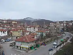
Çamlıdere, Ankara
Çamlıdere is a town and district of Ankara Province in the Central Anatolia region of Turkey, 108 km north-west of the city of Ankara. According to 2010 census, population of the district is 7297 of which 2994 live in the town of Çamlıdere.[3] The district covers an area of 633 km2 (244 sq mi),[4] and the average elevation is 1,175 m (3,855 ft).
Çamlıdere | |
|---|---|
District | |
 | |
 Location of Çamlıdere, Ankara within Turkey. | |
 Çamlıdere Location of Çamlıdere, Ankara within Turkey. | |
| Coordinates: 40°29′25″N 32°28′43″E | |
| Country | |
| Region | Central Anatolia |
| Province | Ankara |
| Government | |
| • Governor | Hüseyin Parlak |
| • Mayor | Hazım Caner Can (AKP) |
| Area | |
| • District | 632.63 km2 (244.26 sq mi) |
| Elevation | 1,175 m (3,855 ft) |
| Population (2012)[2] | |
| • Urban | 2,764 |
| • District | 6,739 |
| • District density | 11/km2 (28/sq mi) |
| Time zone | UTC+2 (EET) |
| • Summer (DST) | UTC+3 (EEST) |
| Postal code | 06xxx |
| Area code(s) | 0312 |
| Licence plate | 06 |
| Website | camlidere.gov.tr |
Çamlıdere was settled by the Seljuk Turks and there are a number of Seljuk period buildings in the area.
Many fossils and petrified forest have been found in the area.
Demographics
The population of Çamlıdere is experiencing a rapid depopulation, especially in rural villages, like many other rural and remote areas in Central Anatolia. The population living in villages decreased from 16,464 to a record-low of 3,915 in the period 1965–2012. The urban population declined slightly from 3,132 to 2,764 in the same period.
| Year | Pop. | ±% p.a. |
|---|---|---|
| 1965 | 19,596 | — |
| 1980 | 18,521 | −0.38% |
| 1990 | 19,365 | +0.45% |
| 2000 | 15,339 | −2.30% |
| 2007 | 9,329 | −6.86% |
| 2008 | 9,862 | +5.71% |
| 2009 | 8,293 | −15.91% |
| 2010 | 7,297 | −12.01% |
| 2011 | 6,993 | −4.17% |
| 2012 | 6,739 | −3.63% |
| 2013 | 7,181 | +6.56% |
| 2014 | 6,781 | −5.57% |
| 2015 | 6,479 | −4.45% |
| 2016 | 6,483 | +0.06% |
| 2017 | 7389
| — |
Çamlıdere today
This is an attractive woodland district with lakes, meadows, a deer park, a scout camp and many other places for camping, walking and picnics. In summertime Çamlıdere is busy with day-trippers from Ankara and there is a growing number of guest-houses for weekenders coming to enjoy the fresh air and open skies. The people in this rural area are typically conservative and religious in outlook.
The summer festival in July features oil-wrestling, music, dance, circumcisions of boys, and pilgrimage to the tomb of Sheikh Ali Semerkandi.
Places of interest
- The country house of former president İsmet İnönü.
Notes
- "Area of regions (including lakes), km²". Regional Statistics Database. Turkish Statistical Institute. 2002. Retrieved 2013-03-05.
- "Population of province/district centers and towns/villages by districts - 2012". Address Based Population Registration System (ABPRS) Database. Turkish Statistical Institute. Retrieved 2013-02-27.
- "Population of city, towns and villages - 2010". Turkish Statistical Institute.
- Statoids. "Statistical information on districts of Turkey". Retrieved 2008-05-05.
- Turkish Statistical Institute
References
- Falling Rain Genomics, Inc. "Geographical information on Çamlıdere, Turkey". Retrieved 2008-03-28.
- Governorship of Çamlıdere, Turkey. "General information on Çamlıdere district of Ankara" (in Turkish). Archived from the original on 2008-02-13. Retrieved 2008-03-28.
External links
- District governor's official website (in Turkish)
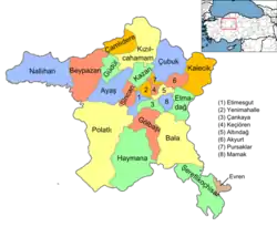
Çamlıdere, Ankara in Ankara Province of Turkey | |||||||||||||||||||||||||||
|---|---|---|---|---|---|---|---|---|---|---|---|---|---|---|---|---|---|---|---|---|---|---|---|---|---|---|---|
| Districts | Districts of Ankara | ||||||||||||||||||||||||||
| |||||||||||||||||||||||||||
Metropolitan municipalities are bolded. | |||||||||||||||||||||||||||