Kızılcahamam
Kızılcahamam is a town and district of Ankara Province in the Central Anatolia region of Turkey, 70 km north of the city of Ankara, near the motorway to Istanbul. According to 2010 census, population of the district is 25,203 of which 16,726 live in the town of Kızılcahamam.[3][4] The district covers an area of 1,712 km², and the average elevation in district center is 975 m.
Kızılcahamam | |
|---|---|
District | |
.jpg.webp) A natural scene from Kızılcahamam | |
 Location of Kızılcahamam within Turkey. | |
 Kızılcahamam Location of Kızılcahamam within Turkey. | |
| Coordinates: 40°28′11″N 32°39′02″E | |
| Country | |
| Region | Central Anatolia |
| Province | Ankara Province |
| Government | |
| • Mayor | Muhittin Güney (AKP) |
| • Governor | Mustafa ÇİT |
| Area | |
| • District | 1,760.76 km2 (679.83 sq mi) |
| Elevation | 975 m (3,199 ft) |
| Population (2012)[2] | |
| • Urban | 16,504 |
| • District | 24,635 |
| • District density | 14/km2 (36/sq mi) |
| Time zone | UTC+2 (EET) |
| • Summer (DST) | UTC+3 (EEST) |
| Postal code | 06xxx |
| Area code(s) | 0312 - 736 |
| Licence plate | 06 |
| Website | www |
The area is mountain and forest, a geographical boundary between central Anatolia and the Black Sea regions.
Kızılcahamam itself is a quiet market town known for its healing hot springs and mineral waters. Nearby Soğuksu National Park contains a scout camp and trails, and areas for picnic in the forest. There are hotels and guest houses including spa hotels. A sculpture of black vulture, an endangered bird species inhabited in the national park, is situated at the entrance of the town.[5]
Climate
The climate in Kızılcahamam is dominated by hot and temperate/mesothermal climate. In winter more precipitation falls than in the summer season. The climate can be classified as Mediterranean climate (Csb) according to Köppen–Geiger climate system. Annual average temperature is 10.4 °C (50.7 °F) and the average annual rainfall 550 mm (22 in).
| Climate data for Kızılcahamam | |||||||||||||
|---|---|---|---|---|---|---|---|---|---|---|---|---|---|
| Month | Jan | Feb | Mar | Apr | May | Jun | Jul | Aug | Sep | Oct | Nov | Dec | Year |
| Daily mean °C (°F) | −0.4 (31.3) |
1.2 (34.2) |
5.1 (41.2) |
9.9 (49.8) |
14.0 (57.2) |
17.3 (63.1) |
20.4 (68.7) |
20.1 (68.2) |
16.6 (61.9) |
11.5 (52.7) |
6.5 (43.7) |
2.1 (35.8) |
10.4 (50.7) |
| Average precipitation mm (inches) | 70 (2.8) |
53 (2.1) |
51 (2.0) |
53 (2.1) |
64 (2.5) |
43 (1.7) |
22 (0.9) |
20 (0.8) |
23 (0.9) |
31 (1.2) |
42 (1.7) |
78 (3.1) |
550 (21.8) |
| Source: Values of Annual Mean Temperature and Precipitation Distribution by Months.[6] | |||||||||||||
Administrative divisions
Towns
- Çeltikçi
- Kızılcahamam
Villages
- Adaköy
- Akdoğan
- Aksak
- Alibey
- Alpagut
- Ayvacık
- Aşağıadaköy
- Aşağıçanlı
- Aşağıhüyük
- Aşağıkese
- Bademli
- Balcılar
- Bayırköy
- Bağlıca
- Bağören
- Başağaç
- Başören
- Belpınar
- Berçinçatak
- Berçinyayalar
- Bezcikuzören
- Beşkonak
- Binkoz
- Bulak
- Ciğirler
- Çalta
- Çavuşlar
- Çeçtepe
- Çırpan
- Çukurca
- Çukurören
- Demirciören
- Değirmenönü
- Doymuşören
- Doğanözü
- Esenler
- Eğerlialören
- Eğerlibaşköy
- Eğerlidereköy
- Eğerlikozören
- Gebeler
- Gökbel
- Gölköy
- Gümele
- Güneysaray
- Güvem
- İğdir
- İğmir
- İnceğiz
- İyceler
- Hıdırlar
- Kalemler
- Karaağaç
- Karacaören
- Kasımlar
- Kavaközü
- Kocalar
- Kurumcu
- Kuşcuören
- Kınık (Aşağı)
- Kınık (Yukarı)
- Kırkırca
- Kırköy
- Kışlak
- Kızık
- Kızılca
- Kızılcaören
- Mahkemeağcin
- Olucak
- Ortaköy
- Otacı
- Oğlakçı
- Örencik
- Pazar Başören
- Pazar
- Salın
- Saraycık
- Sarayköy
- Saraçköy
- Sazak
- Semeler
- Semer
- Süleler
- Şahinler
- Tahtalar
- Taşlıca
- Turnalı
- Ugurlu
- Üçbaş
- Üyücek
- Yakakaya
- Yanık
- Yağcıhüseyin
- Yeni Dereneci
- Yeşilköy
- Yukarıhüyük
- Yukarıkaraören
- Yukarıkese
- Yukarıçanlı
- Yıldırımdemirciler
- Yıldırımhacılar
- Yıldırımyağlıca
- Yıldırımçatak
- Yıldırımören
Notes
- "Area of regions (including lakes), km²". Regional Statistics Database. Turkish Statistical Institute. 2002. Retrieved 2013-03-05.
- "Population of province/district centers and towns/villages by districts - 2012". Address Based Population Registration System (ABPRS) Database. Turkish Statistical Institute. Retrieved 2013-02-27.
- Statistical Institute
- GeoHive. "Statistical information on Turkey's administrative units". Retrieved 2008-03-26.
- "Soğuksu Milli Parkı" (in Turkish). Orman ve Su İşleri Bakanlığı 9. Bölge Müdürülüğü. Retrieved 2016-04-02.
- "İklim: Kızılcahamam" (in Turkish). Climate-Data. Retrieved 2016-04-18.
References
- Falling Rain Genomics, Inc. "Geographical information on Kızılcahamam, Turkey". Retrieved 2008-03-26.
- Governorship of Kızılcahamam, Turkey. "Geographical information on Kızılcahamam district of Ankara" (in Turkish). Retrieved 2008-03-26.
External links
| Wikimedia Commons has media related to Kızılcahamam. |
- District governor's official website (in Turkish)
- District municipality's official website (in Turkish)
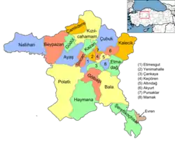
Kızılcahamam in Ankara Province of Turkey | |||||||||||||||||||||||||||
|---|---|---|---|---|---|---|---|---|---|---|---|---|---|---|---|---|---|---|---|---|---|---|---|---|---|---|---|
| Districts | Districts of Ankara | ||||||||||||||||||||||||||
| |||||||||||||||||||||||||||
Metropolitan municipalities are bolded. | |||||||||||||||||||||||||||