Etimesgut
Etimesgut or Etimesut, formerly Ahimesut, is a metropolitan district of Ankara Province in the Central Anatolia region of Turkey, mainly consisting of large public housing projects, 25 km (16 mi) from Ankara city centre. According to 2010 census, the population of Etimesgut is 386,879.[3][4] The district covers an area of 49 km2 (19 sq mi),[5] and the average elevation is 807 m (2,648 ft).
Etimesgut | |
|---|---|
District | |
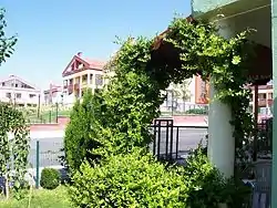 Eryaman neighborhood in Etimesgut | |
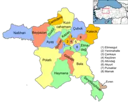 Location of Etimesgut within Turkey. | |
 Etimesgut Location of Etimesgut within Turkey. | |
| Coordinates: 39°57′N 32°40′E | |
| Country | |
| Region | Central Anatolia |
| Province | Ankara |
| Government | |
| • Governor | Recep Erkılıç |
| • Mayor | Enver Demirel (MHP) |
| Area | |
| • District | 49.19 km2 (18.99 sq mi) |
| Elevation | 807 m (2,648 ft) |
| Population (2012)[2] | |
| • Urban | 425,947 |
| • District | 425,947 |
| • District density | 8,700/km2 (22,000/sq mi) |
| Time zone | UTC+2 (EET) |
| • Summer (DST) | UTC+3 (EEST) |
| Postal code | 06xxx |
| Area code(s) | 0312 |
| Licence plate | 06 |
| Website | www.etimesgut.gov.tr |
Demographics
| Year | Pop. | ±% p.a. |
|---|---|---|
| 2007 | 289,601 | — |
| 2008 | 313,770 | +8.35% |
| 2009 | 347,267 | +10.68% |
| 2010 | 386,879 | +11.41% |
| 2011 | 414,739 | +7.20% |
| 2012 | 425,947 | +2.70% |
| 2013 | 469,626 | +10.25% |
| 2014 | 501,351 | +6.76% |
| 2015 | 527,959 | +5.31% |
| 2016 | 542,752 | +2.80% |
History
Archaeological research shows habitation since 2000 BC, including a Phrygian settlement in the 8th century BC. Then of course the district began to share the history of the city of Ankara with its Lydians, Persians, Galatians, Ancient Romans, Byzantines and finally Turks. Etimesgut is on the ancient Silk Road to the orient, and still today the road and railway from Ankara to Istanbul pass through the district.
Atatürk was fond of the area and would come here to ride horses and chat to the locals. He had a room in the building that is the public health laboratory today, and many other public buildings, including the hospital and the post office, that were built by his order still stand today.
Etimesgut began as a housing project of 50 homes ordered by Atatürk in 1924 to accommodate Turkish refugees from Bulgaria. From the 1950s, as poverty forced people to migrate from the countryside into the city much illegal housing gecekondu was thrown up in this district. Some of this has been replaced by public housing projects such as Elvankent, Eryaman and Güzelkent and also military and civil service accommodation. However much gecekondu remains, inhabited by working-class people from cities such as Erzurum, many of whom commute to jobs in the city of Ankara. The Islamic terrorist organisation Hizbullah had a number of hidden cells here in the 1990s.
Present
The area has only the most basic shops and amenities. Almost all of the housing in Etimesgut is apartment buildings except for the Güzelkent project. As building land in the city of Ankara is now impossible to find, areas like this on the fringes of the city, where building land is cheap, are growing faster and faster.
Public buildings include the sugar factory, the Turkish aviation authority headquarters at Etimesgut Airport and a military training camp.
The local football team Etimesgut Şekerspor has a chequered history; in recent years it has gained popularity by hiring former national team player Sergen Yalçın.
Planned security campus
The construction of a new building in Etimesgut is underway, to serve as the joint new headquarters of the Turkish National Intelligence Organization (MİT), the Ministry of National Defence, and the Turkish General Staff together with the commands of the Army, Navy and Air Force branches of the Turkish Armed Forces. Reportedly, the move, which will turn the area into a "security campus" comparable to the US Pentagon, is part of measures taken after the failed 2016 Turkish coup d'état attempt.[7][8]
Neighborhoods
- Alsancak
- Altay
- Atakent
- Ayyıldız
- Bağlıca
- Bahçekapı
- Elvan
- Elvankent
- Erler
- Etiler
- Eryaman
- Güzelkent
- İstasyon
- Kazım Karabekir
- Oğuzlar
- Piyade
- Süvari
- Şehit Osman Avcı
- Şeyh Şamil
- 30 Ağustos
- Topçu
- Tunahan
- Şeker
- Yapracık
- Yavuz Selim
- Yeşilova
Former broadcasting site
At Etimesgut, there was a longwave broadcasting station with two masts each 256 metres tall, which worked on 198 kHz. The station, whose masts stood at 39°56′24.07″N 32°40′3.2″E and at 39°56′14.33″N 32°40′3.03″E was built in 1938 and shut-down in 2004 and was afterwards demolished.
Places of interest
Image gallery
Güzelkent houses 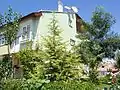
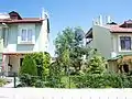
A house in Güzelkent 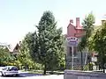
Villas in Güzelkent 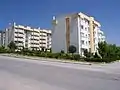
Güzelkent Towers 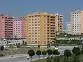
Eryaman housing project
Notes
- "Area of regions (including lakes), km²". Regional Statistics Database. Turkish Statistical Institute. 2002. Retrieved 2013-03-05.
- "Population of province/district centers and towns/villages by districts - 2012". Address Based Population Registration System (ABPRS) Database. Turkish Statistical Institute. Retrieved 2013-02-27.
- Statistical Institute
- GeoHive. "Statistical information on Turkey's administrative units". Retrieved 2008-03-29.
- Statoids. "Statistical information on districts of Turkey". Retrieved 2008-05-01.
- Turkish Statistical Institute
- Deniz Çiçek (4 October 2016). "MİT, MSB ve komutanlıklar Etimesgut'ta toplanacak". Haberturk (in Turkish). Retrieved 5 October 2016.
- "'Turkish Pentagon' to be formed in capital Ankara: Report". Hürriyet Daily News. 4 October 2016. Retrieved 5 October 2016.
References
- Falling Rain Genomics, Inc. "Geographical information on Etimesgut, Turkey". Retrieved 2008-03-29.
- Governorship of Etimesgut, Turkey. "Brief history and geography of Etimesgut" (in Turkish). Archived from the original on 2008-03-15. Retrieved 2008-03-29.
- Kenthaber.com. "General information on Etimesgut" (in Turkish). Archived from the original on 2011-07-19. Retrieved 2008-03-29.
External links
| Wikimedia Commons has media related to Etimesgut. |
- District governor's official website (in Turkish)
- District municipality's official website (in Turkish)
Etimesgut in Ankara Province of Turkey | |||||||||||||||||||||||||||
|---|---|---|---|---|---|---|---|---|---|---|---|---|---|---|---|---|---|---|---|---|---|---|---|---|---|---|---|
| Districts | Districts of Ankara | ||||||||||||||||||||||||||
| |||||||||||||||||||||||||||
Metropolitan municipalities are bolded. | |||||||||||||||||||||||||||