Çubuk, Ankara
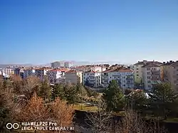
Çubuk is a town and district of Ankara Province in the Central Anatolia region of Turkey, outside the city of Ankara. Çubuk is a flat plain 35 km north of the city where Ankara airport is located. According to 2000 census, population of the district is 81,747 of which 76,716 live in the town of Çubuk.[3] The district covers an area of 1,362 km2 (526 sq mi),[4] and the average elevation is 1,100 m (3,609 ft).
Çubuk | |
|---|---|
District | |
 | |
 Location of Çubuk, Ankara within Turkey. | |
 Çubuk Location of Çubuk, Ankara within Turkey. | |
| Coordinates: 40°14′N 33°02′E | |
| Country | |
| Region | Central Anatolia |
| Province | Ankara |
| Government | |
| • Governor | Cemal Şahin |
| • Mayor | Lokman Özden (AKP) |
| Area | |
| • District | 1,361.60 km2 (525.72 sq mi) |
| Elevation | 1,100 m (3,600 ft) |
| Population (2012)[2] | |
| • Urban | 77,958 |
| • District | 82,614 |
| • District density | 61/km2 (160/sq mi) |
| Time zone | UTC+2 (EET) |
| • Summer (DST) | UTC+3 (EEST) |
| Postal code | 06xxx |
| Area code(s) | 0312 |
| Licence plate | 06 |
| Website | cubuk.gov.tr |
Origin
Çubuk was among the first places that were captured during the conquest of Anatolia by the Seljuk Turks. The district is said to be named after Çubuk Bey, the Seljuk commander that captured the region. Kışlacık, Yeşilkent, Yaylak, Okçular, Çatköy, and Ahurlar are places located in Çubuk and used by Yıldırım Bayezid during the 1402 Battle of Ankara which was fought between the Ottoman Empire and Timur.
History
Çubuk is a settlement that was established when the Turks invaded and took control of Anatolia. The district is located in the northeast of Ankara. Çubuk gained historical importance when Yıldırım Bayezid used Çubuk in the Battle of Ankara which was fought between Timur and the Ottoman Empire. Most of the villages that make up the district were formed by the remnants of armies defeated or left behind after the battle.
Çubuk is in an area that has been crossed by trade routes since the Middle Ages. Many settlements were founded in this region because of the agricultural areas and the Çubuk River. The settlement is thought to have been founded after the conquest of Ankara and was under the control of many civilizations, for example the Hattians, Hittites, Phrygians, Romans, Byzantines, Seljuks and Ottomans. This is why the remains of these empires can be found in the district. Ruins in the Balıkhisar Neighborhood, castle ruins in Camili and Çatkoy, a marble lion sculpture in the Güldarpı neighborhood and remains of graves in the Yakup Derviş neighborhood are among the remains of these empires. Also, the Sultan Siyemi Tomb, Kutoren Village Mosque, Melikshah Village Stone Bath, Mahmutoglan Village Mosque, and Cubuk Karsiyaka Mosque are among the historical monuments located in Çubuk.
It is believed that the Turks settled in the region after they invaded and took control of the Anatolia. The Turks who came to the region brought their families, traditions, customs, and beliefs.
Demographics
| Year | Pop. | ±% p.a. |
|---|---|---|
| 2007 | 83,826 | — |
| 2008 | 80,123 | −4.42% |
| 2009 | 81,270 | +1.43% |
| 2010 | 81,747 | +0.59% |
| 2011 | 82,156 | +0.50% |
| 2012 | 82,614 | +0.56% |
| 2013 | 83,449 | +1.01% |
| 2014 | 84,636 | +1.42% |
| 2015 | 86,055 | +1.68% |
| 2016 | 87,603 | +1.80% |
| 2017 | 90,063 | +2.81% |
Villages
- Abadan
- Ağılcık
- Akbayır
- Akkuzulu
- Aşağıçavundur
- Aşağıemirler
- Aşağıobruk
- Avcıova
- Camili
- Çatköy
- Çitköy
- Dağkalfat
- Dalyasan
- Dedeler
- Demirci
- Dumlupınar
- Durhasan
- Eğriekin
- Esenboğa
- Eskiçöte
- Gökçedere
- Güldarbı
- Gümüşyayla
- Hacılar
- İkipınar
- İmamhüseyin
- Kapaklı
- Karaağaç
- Karaçam
- Karadana
- Karaköy
- Karaman
- Karataş
- Kargın
- Karşıyaka
- Kavaklı
- Kışlacık
- Kızılca
- Kızılören
- Kızılöz
- Kösrelik
- Kösrelikkızığı
- Küçükali
- Kuruçay
- Kutuören
- Kuyumcuköy
- Mahmutoğlan
- Melikşah
- Meşeli
- Mutlu
- Nusratlar
- Okçular
- Ömercik
- Ovacık
- Oyumiğde
- Özlüce
- Saraycık
- Sarıkoz
- Sarısu
- Sele
- Sığırlıhacı
- Sirkeli
- Sünlü
- Susuz
- Tahtayazı
- Taşpınar
- Tuğlaköy
- Uluağaç
- Yakuphasan
- Yaylak
- Yazır
- Yazlıca
- Yenice
- Yeşilkent
- Yiğitli
- Yıldırımaydoğan
- Yıldırımelören
- Yıldırımevci
- Yılmazköy
- Yukarıçavundur
- Yukarıemirler
- Yukarıobruk
- Yuva
Places of interest
- Karagöl rocks, picnic area
Notes
- "Area of regions (including lakes), km²". Regional Statistics Database. Turkish Statistical Institute. 2002. Retrieved 2013-03-05.
- "Population of province/district centers and towns/villages by districts - 2012". Address Based Population Registration System (ABPRS) Database. Turkish Statistical Institute. Retrieved 2013-02-27.
- Statistical Institute
- Statoids. "Statistical information on districts of Turkey". Retrieved 2008-04-23.
- Turkish Statistical Institute
References
- Falling Rain Genomics, Inc. "Geographical information on Çubuk, Turkey". Retrieved 2008-03-28.
- Kenthaber.com. "General information on Çubuk district of Ankara" (in Turkish). Archived from the original on 2011-07-19. Retrieved 2008-03-28.
- Governorship of Çubuk, Turkey. "Physical structure and map of Çubuk" (in Turkish). Archived from the original on 2007-12-05. Retrieved 2008-03-28.
- 1965-2016 Turkish Statistical Institute. It was archived from its source on April 19, 2020.
- “Birsen Edanur Yıldırım - Settlement and Population of Ankara Sanjak in Terms of Historical Geography (1871-1907), Settlements by Salname, Çubukabad Town p.89 - Ankara 2006” . It was archived from its source on September 21, 2014. Retrieved March 16, 2012.
External links
- District governor's official website (in Turkish)
- District municipality's official website (in Turkish)
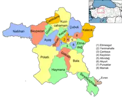
Çubuk, Ankara in Ankara Province of Turkey | |||||||||||||||||||||||||||
|---|---|---|---|---|---|---|---|---|---|---|---|---|---|---|---|---|---|---|---|---|---|---|---|---|---|---|---|
| Districts | Districts of Ankara | ||||||||||||||||||||||||||
| |||||||||||||||||||||||||||
Metropolitan municipalities are bolded. | |||||||||||||||||||||||||||