Güdül
Güdül is a rural town and district of Ankara Province in the Central Anatolia region of Turkey, 90 km north-west of the city of Ankara, off the motorway to Istanbul. The district covers an area of 419 km², and the average elevation is 720 m. According to 2010 census, population of the district is 8971 of which 2623 live in the town of Güdül with the majority in the surrounding countryside.[3][4]
Güdül | |
|---|---|
District | |
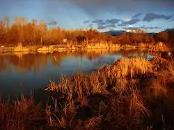 A natural scene from Güdül | |
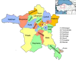 Location of Güdül within Turkey. | |
 Güdül Location of Güdül within Turkey. | |
| Coordinates: 40°12′40″N 32°14′34″E | |
| Country | |
| Region | Central Anatolia |
| Province | Ankara Province |
| Government | |
| • Governor | Ekrem Canalp |
| • Mayor | Hüseyin Erdoğan (AKP) |
| Area | |
| • District | 383.65 km2 (148.13 sq mi) |
| Elevation | 720 m (2,360 ft) |
| Population (2012)[2] | |
| • Urban | 2,591 |
| • District | 8,656 |
| • District density | 23/km2 (58/sq mi) |
| Time zone | UTC+2 (EET) |
| • Summer (DST) | UTC+3 (EEST) |
| Postal code | 06xxx |
| Area code(s) | 0312 |
| Licence plate | 06 |
| Website | www.gudul.gov.tr |
Güdül is a mountainous district with a dry climate featuring cold winters (down to -20 °C), hot summers (up to 35 °C) and a little rain in spring and autumn. There is some agriculture and the crops include hot peppers and chick peas, which are dried and sold as leblebi.
History
Research shows occupation since prehistoric times, and caves along the river Kirmir contain stone workings apparently by the Hittites (2000 BC). Later the area was occupied by Phrygians, Ancient Romans and Byzantines (one of the caves has a carved cross from the early spread of Christianity under Roman rule).
In 1071, the Byzantine armies were defeated by the Turks at the battle of Malazgirt, and soon afterwards all of central Anatolia came under Turkish control. Güdül was occupied by Seljuk Turks, including the lord of Ankara, Şehabüldevle Güdül Bey.
Administrative divisions
Places of interest
- The lake and forest near the village of Sorgun, north of Güdül
- The caves in the valley of the Kirmir
Image gallery
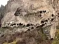
Man made caves 
A road in Güdül 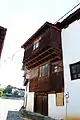
Traditional house 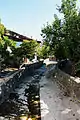
A stream flowing through Güdül 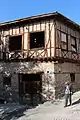
An empty traditional house in Güdül 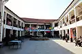
View of the courtyard from Güdül town center
Notes
- "Area of regions (including lakes), km²". Regional Statistics Database. Turkish Statistical Institute. 2002. Retrieved 2013-03-05.
- "Population of province/district centers and towns/villages by districts - 2012". Address Based Population Registration System (ABPRS) Database. Turkish Statistical Institute. Retrieved 2013-02-27.
- Statistical Institute
- GeoHive. "Statistical information on Turkey's administrative units". Retrieved 2008-03-26.
References
- Falling Rain Genomics, Inc. "Geographical information on Güdül, Turkey". Retrieved 2008-03-26.
- Governorship of Güdül. "Introductory information on Güdül, Turkey" (in Turkish). Archived from the original on October 24, 2008. Retrieved 2008-03-26.
External links
| Wikimedia Commons has media related to Güdül. |
- District governor's official website (in Turkish)