Nallıhan
Nallıhan is a rural town and district of Ankara Province in the Central Anatolia region of Turkey, 157 km from the city of Ankara. According to 2010 census, population of the district is 30,571 of which 12,457 live in the town of Nallıhan.[3][4] The district covers an area of 1,978 km², and the average elevation is 625 m.
Nallıhan | |
|---|---|
District | |
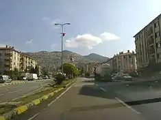 Nallıhan district center | |
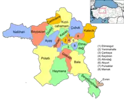 Location of Nallıhan within Turkey. | |
 Nallıhan Location of Nallıhan within Turkey. | |
| Coordinates: 40°11′01″N 31°21′02″E | |
| Country | |
| Province | Ankara |
| Government | |
| • Mayor | Ahmet Adnan Okur (MHP) |
| • Governor | Ömer Toraman |
| Area | |
| • District | 1,972.51 km2 (761.59 sq mi) |
| Elevation | 625 m (2,051 ft) |
| Population (2012)[2] | |
| • Urban | 12,125 |
| • District | 30,299 |
| • District density | 15/km2 (40/sq mi) |
| Time zone | UTC+2 (EET) |
| • Summer (DST) | UTC+3 (EEST) |
| Postal code | 06920 |
| Area code(s) | 0312 |
| Licence plate | 06 |
| Website | www |
Name
Nallıhan is named after a caravanserai on the ancient Silk Road to the Orient next to the river Nallı. There has been a settlement here for thousands of years.
Today
Today the town is known for its needlework and local cuisine including stuffed vine-leaves, pilav and pastries. The countryside is used for growing rice and grapes.
Nallıhan is one of many towns that claims to be the burial place of Taptuk Emre, who was the hodja (teacher in Islamic studies) of the folk-poet and dervish Yunus Emre. Nallıhan Davutoğlan Bird Paradise attracts local and foreign tourists.[5]
Administrative structure
Villages
- Akdere
- Aksu
- Alanköy
- Aliefe
- Alpağut
- Arkutça
- Atça
- Aydoğmuş
- Aşağıbağdere
- Aşağıbağlıca
- Aşağıkavacık
- Belenalan
- Belenören
- Beyalan
- Beycik
- Beydili
- Bozyaka
- Cendere
- Çalıcaalan
- Çamalan
- Çiller
- Çive
- Çulhalar
- Danişment
- Davutoğlan
- Demirköy
- Dereköy
- Doğandere
- Döğmeci
- Emremsultan
- Epçeler
- Ericek
- Eymir
- Eğriköy
- Gökçeöz
- Güzelöz
- Hacıhasanlar
- Hıdırlar
- İslamalanı
- Kabaca
- Kadıköy
- Karacasu
- Karahisar
- Karahisargölcük
- Karahisarkozlu
- Karaköy
- Kavakköy
- Kulu
- Kuruca
- Kuzucular
- Meyildere
- Meyilhacılar
- Nallıdere
- Nallıgölcük
- Nebioğlu
- Osmanköy
- Ozanköy
- Ömerşeyhler
- Öşürler
- Sarıkaya
- Soğukkuyu
- Subaşı
- Tekirler
- Tekkeköy
- Tepeköy
- Uluhan
- Uluköy
- Uzunöz
- Yakapınar
- Yenice
- Yeşilyurt
- Yukarıbağdere
- Yukarıbağlıca
- Yukarıkavacık
Places of interest
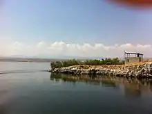
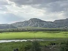
- Nallıhan Kuş Cenneti - Sarıyar reservoir is teeming with bird-life. It is a natural habitat for several endangered bird species in Turkey.
- Kocahan - Ottoman vizier Nasuh Pasha stopped by this place in 1599 and made it built. It is in a rectangular shape and has cafes and shops in its 46 rooms.[6]
- Ilıca/Uyuzsuyu waterfall - The waterfall that reside in the road to Göynük, is the only waterfall in the borders of Turkey's capital, Ankara. It got its name "Uyuzsuyu" because there is a belief that its water cures skin diseases.[7]
See also
Notes
- "Area of regions (including lakes), km²". Regional Statistics Database. Turkish Statistical Institute. 2002. Retrieved 2013-03-05.
- "Population of province/district centers and towns/villages by districts - 2012". Address Based Population Registration System (ABPRS) Database. Turkish Statistical Institute. Retrieved 2013-02-27.
- Statistical Institute
- GeoHive. "Statistical information on Turkey's administrative units". Retrieved 2008-03-26.
- Selahattin Sönmez (10 June 2016). "Photographers flock to Nallıhan Bird Paradise". Hurriyet Daily News.
- "(Turkish) Official website of the district, "Historical heritages"".
- "(Turkish)Official website of the district, "cultural heritages."".
References
- Falling Rain Genomics, Inc. "Geographical information on Nallıhan, Turkey". Retrieved 2008-03-26.
- Governorship of Nallıhan, Turkey. "Geographical information on Nallıhan district of Ankara" (in Turkish). Archived from the original on 2008-03-03. Retrieved 2008-03-26.
External links
| Wikimedia Commons has media related to Nallıhan. |
- Nallıhan website (in Turkish)
- District governor's official website (in Turkish)
- District municipality's official website (in Turkish)
- A local information website (in Turkish)
Nallıhan in Ankara Province of Turkey | |||||||||||||||||||||||||||
|---|---|---|---|---|---|---|---|---|---|---|---|---|---|---|---|---|---|---|---|---|---|---|---|---|---|---|---|
| Districts | Districts of Ankara | ||||||||||||||||||||||||||
| |||||||||||||||||||||||||||
Metropolitan municipalities are bolded. | |||||||||||||||||||||||||||